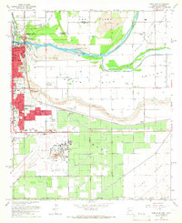
1965 Map of Yuma East
USGS Topo · Published 1966About this map
The Colorado River and Gila River converge in this mid-1960s study, defining a landscape of intensive irrigation and military presence at the California-Arizona border. The city of Yuma sits at the western edge, home to the Yuma Territorial Prison and the St Thomas Yuma Indian Mission, which overlooks the river junction. Extensive agricultural development is evident across the Yuma Mesa and the South Gila Valley, where a complex network including the Main Canal and South Gila Canal feeds the desert soil.
Find a feature on this map
58 named features on this map. Tap any name to fly to it.
Don’t see what you’re looking for? This feature index may not catch every label — zoom into the map to look around manually.
Map Details
Editions of this 1965 Yuma East Map
Other maps of this area

1903 · Yuma
USGS Topo · 1:125,000

1905 · Yuma
USGS Topo · 1:125,000

1926 · Fortuna
USGS Topo · 1:62,500

1929 · Fortuna
USGS Topo · 1:62,500

1929 · Laguna
USGS Topo · 1:62,500

1940 · Yuma
USGS Topo · 1:62,500

1942 · Yuma
USGS Topo · 1:250,000

1943 · Laguna
USGS Topo · 1:62,500

1945 · Picacho Peak
USGS Topo · 1:62,500

1945 · Yuma
USGS Topo · 1:62,500