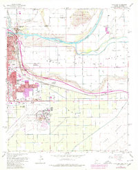
1965 Map of Yuma East
USGS Topo · Published 1979About this map
The Colorado River and Gila River converge in this mid-century portrait of a desert hub where California and Arizona meet. The landscape is defined by the heavy infrastructure of water and transport, from the Main Canal and South Gila Canal feeding the South Gila Valley to the Southern Pacific railroad lines. Urban expansion in Yuma is evident near the Yuma Territorial Prison State Historic Park and the Courthouse, while the southern reaches are dominated by the US Marine Corps Air Station and Yuma International Airport. Cultural landmarks like the St Thomas Yuma Indian Mission and several local schools, including Ham School and Rolle Sch, provide a detailed view of the community's mid-twentieth-century development before further desert urbanization.
Find a feature on this map
44 named features on this map. Tap any name to fly to it.
Don’t see what you’re looking for? This feature index may not catch every label — zoom into the map to look around manually.
Map Details
Editions of this 1965 Yuma East Map
Other maps of this area

1903 · Yuma
USGS Topo · 1:125,000

1905 · Yuma
USGS Topo · 1:125,000

1926 · Fortuna
USGS Topo · 1:62,500

1929 · Fortuna
USGS Topo · 1:62,500

1929 · Laguna
USGS Topo · 1:62,500

1940 · Yuma
USGS Topo · 1:62,500

1942 · Yuma
USGS Topo · 1:250,000

1943 · Laguna
USGS Topo · 1:62,500

1945 · Picacho Peak
USGS Topo · 1:62,500

1945 · Yuma
USGS Topo · 1:62,500