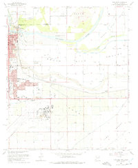
1965 Map of Yuma East
USGS Topo · Published 1975About this map
The confluence of the Colorado River and the Gila River defines this landscape at the intersection of California and Arizona. The city of Yuma is shown in detail, featuring its civic core with the Courthouse, Post Office, and the notable Yuma Territorial Prison perched near the riverbank. The desert environment is heavily managed by a network of irrigation works, including the Main Canal, South Gila Canal, and several others serving the fertile South Gila Valley.
Find a feature on this map
49 named features on this map. Tap any name to fly to it.
Don’t see what you’re looking for? This feature index may not catch every label — zoom into the map to look around manually.
Map Details
Editions of this 1965 Yuma East Map
Other maps of this area

1903 · Yuma
USGS Topo · 1:125,000

1905 · Yuma
USGS Topo · 1:125,000

1926 · Fortuna
USGS Topo · 1:62,500

1929 · Fortuna
USGS Topo · 1:62,500

1929 · Laguna
USGS Topo · 1:62,500

1940 · Yuma
USGS Topo · 1:62,500

1942 · Yuma
USGS Topo · 1:250,000

1943 · Laguna
USGS Topo · 1:62,500

1945 · Picacho Peak
USGS Topo · 1:62,500

1945 · Yuma
USGS Topo · 1:62,500