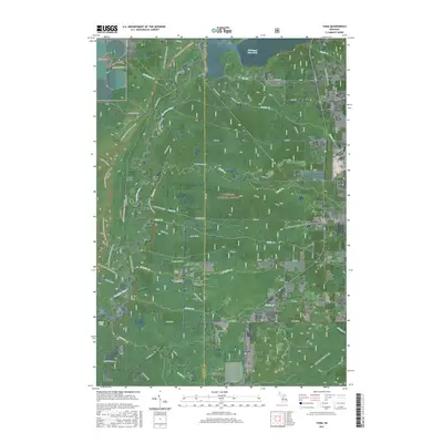
2017 Map of Yuma
USGS Topo · Published 2017About this map
The Manistee River carves a deep path through the northwestern corner of the Manistee National Forest, creating a landscape defined by significant elevation changes and hydroelectric development. This 2017 survey details the river's course between the Hodenpyl Dam Pond and Tippy Dam, passing through areas like Sweets Ravine and Flower Flats. The settlement of Yuma sits on the eastern edge of the quadrangle along the Old M-37 corridor, supported by local landmarks such as Yuma Cem.
Find a feature on this map
73 named features on this map. Tap any name to fly to it.
Don’t see what you’re looking for? This feature index may not catch every label — zoom into the map to look around manually.
Map Details
Editions of this 2017 Yuma Map
This is the sole edition of this map. No revisions or reprints were ever made.
Other maps of this area

1933 · Peacock NE
USGS Topo · 1:31,680

1933 · Luther NW
USGS Topo · 1:31,680

1933 · Peacock NW
USGS Topo · 1:31,680

1954 · Traverse City
USGS Topo · 1:250,000

1956 · Mesick
USGS Topo · 1:62,500

1957 · Copemish
USGS Topo · 1:62,500

1957 · Luther
USGS Topo · 1:62,500

1957 · Wellston
USGS Topo · 1:62,500

1958 · Traverse City
USGS Topo · 1:250,000
1976 · Wellston NE
USGS Topo · 1:24,000