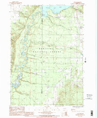
1987 Map of Yuma
USGS Topo · Published 1988About this map
The Manistee River winds through a landscape of heavy conservation and early-century infrastructure at the border of Manistee and Wexford counties. This 1980s-era survey documents the hydrological management of the region, anchored by the Hodenpyl Dam and the expansive Hodenpyl Dam Pond in the north, with the upper reaches of Tippy Dam appearing downstream. Much of the terrain is managed as the Manistee National Forest, characterized by numerous cold-water tributaries including Slagle Creek, Dead Creek, and Hinton Creek. Small rural settlements like Yuma, Seaton, and Hinton provide a window into the area's residential footprint, while features like the Landing Strip and local Sand Pit reflect the light industrial and transport needs of this forested interior. Genealogists will find a designated Cem near the township lines of Springville and Slagle, preserving local family history within the woods.
Find a feature on this map
34 named features on this map. Tap any name to fly to it.
Don’t see what you’re looking for? This feature index may not catch every label — zoom into the map to look around manually.
Map Details
Editions of this 1987 Yuma Map
This is the sole edition of this map. No revisions or reprints were ever made.
Other maps of this area

1933 · Peacock NE
USGS Topo · 1:31,680

1933 · Luther NW
USGS Topo · 1:31,680

1933 · Peacock NW
USGS Topo · 1:31,680

1954 · Traverse City
USGS Topo · 1:250,000

1956 · Mesick
USGS Topo · 1:62,500

1957 · Copemish
USGS Topo · 1:62,500

1957 · Luther
USGS Topo · 1:62,500

1957 · Wellston
USGS Topo · 1:62,500

1958 · Traverse City
USGS Topo · 1:250,000
1976 · Wellston NE
USGS Topo · 1:24,000
Featured Places
- Slagle Township, MI
- Dickson Township, MI
- Marilla Township, MI
- Norman Township, MI
- South Branch Township, MI