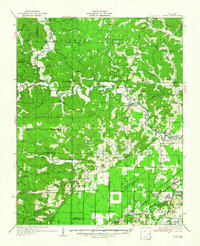
1935 Map of Zalma
USGS Topo · Published 1935About this map
Castor River defines the drainage of this southeast Missouri landscape, winding through a complex network of timbered hills and the engineered lowlands of the Bootheel fringe. In the mid-1930s, the northern portion of the quadrangle is characterized by a dense concentration of rural community centers like Gipsy and Zalma, supported by an extensive system of one-room schoolhouses such as Pond Creek Sch and Lower Turkey Creek Sch. To the south, the terrain shifts abruptly as the river exits the hills. Here, the landscape is heavily modified by drainage infrastructure, including Snake Bluff Ditch and Grapevine Ridge Ditch, facilitating agriculture near the St Louis San Francisco RR. This rail line connects the river towns of Greenbrier and Sturdivant, highlighting the era's transition from river-dependent transport to rail-and-road connectivity via State Highway No 34.
Find a feature on this map
84 named features on this map. Tap any name to fly to it.
Don’t see what you’re looking for? This feature index may not catch every label — zoom into the map to look around manually.
Map Details
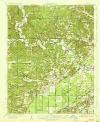
Editions of this 1935 Zalma Map
3 editions found
Other maps of this area

1930 · Coldwater
USGS Topo · 1:62,500

1933 · Marble Hill
USGS Topo · 1:62,500

1933 · Marquand
USGS Topo · 1:62,500

1934 · Greenville
USGS Topo · 1:62,500

1934 · Bloomfield
USGS Topo · 1:62,500

1934 · Advance
USGS Topo · 1:62,500

1934 · Puxico
USGS Topo · 1:62,500

1935 · Poplar Bluff
USGS Topo · 1:62,500

1935 · Zalma
USGS Topo · 1:62,500

1937 · Marble Hill
USGS Topo · 1:62,500