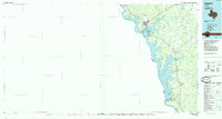
1985 Map of Zapata
USGS Topo · Published 1993About this map
The Rio Grande and the expansive Falcon Reservoir dominate this South Texas borderland, where the international boundary separates Texas from Tamaulipas, Mexico. The 1980s landscape is shaped by the massive engineering of the Falcon Dam, which created the reservoir and established the nearby communities of Falcon Village and Falcon Heights. Along the eastern shore, the town of Zapata serves as a primary hub, flanked by residential developments like Siesta Shores and Las Palmas. The map captures the intricate drainage system of the Rio Grande valley, with numerous seasonal streams such as Arroyo Molletes and Arroyo de las Veleño cutting through the brushland. Further inland, the small settlement of Bustamante remains a point of interest for those tracing the historic ranching and agricultural patterns of the brush country, while the Beckwith Arm highlights the deep reach of the impounded waters into the Texas interior.
Find a feature on this map
49 named features on this map. Tap any name to fly to it.
Don’t see what you’re looking for? This feature index may not catch every label — zoom into the map to look around manually.
Map Details
Editions of this 1985 Zapata Map
2 editions found
Other maps of this area

1938 · Falcon
USGS Topo · 1:62,500

1938 · El Sauz
USGS Topo · 1:62,500

1938 · Cuevitas
USGS Topo · 1:62,500

1939 · Randado
USGS Topo · 1:62,500

1940 · Randado
USGS Topo · 1:62,500

1940 · Mogotes Hill
USGS Topo · 1:62,500

1942 · San Ygnacio
USGS Topo · 1:62,500

1949 · Mc Allen
USGS Topo · 1:250,000

1954 · McAllen
USGS Topo · 1:250,000

1956 · Mogotes Hill
USGS Topo · 1:62,500