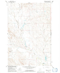
1960 Map of Zempel Lake
USGS Topo · Published 1992About this map
Big Porcupine Creek meanders through this portion of Rosebud County, carving a network of drainage channels across a landscape defined by ranching and coulees. Surveyed in 1960 as part of the Department of the Interior's development program for the Missouri River Basin, the map reveals a sparsely populated terrain where land use is marked by fine fence lines and family-operated holdings. The namesake Zempel Lake sits in the southeast, flanked by the Zempel Ranch and the winding course of McGraw Coulee. Other legacy operations, including the Johnson Ranch, Olson Ranch, and Richardson Ranch, highlight the distributed nature of early 20th-century Montana homesteading. Water remains the central organizing force of the region, from the seasonal flows of Sun Coulee to the confluence of West Blacktail Creek and East Blacktail Creek.
Find a feature on this map
15 named features on this map. Tap any name to fly to it.
Don’t see what you’re looking for? This feature index may not catch every label — zoom into the map to look around manually.
Map Details
Editions of this 1960 Zempel Lake Map
2 editions found
Other maps of this area

1954 · Forsyth
USGS Topo · 1:250,000

1957 · Forsyth
USGS Topo · 1:250,000

1958 · Forsyth
USGS Topo · 1:250,000

1960 · Hagen Ranch
USGS Topo · 1:24,000

1960 · Vananda
USGS Topo · 1:24,000

1960 · Ahles
USGS Topo · 1:24,000

1960 · Thebes
USGS Topo · 1:24,000

1960 · Brown Coulee
USGS Topo · 1:24,000

1960 · Zempel Lake
USGS Topo · 1:24,000

1968 · Donleys Reservoir
USGS Topo · 1:24,000