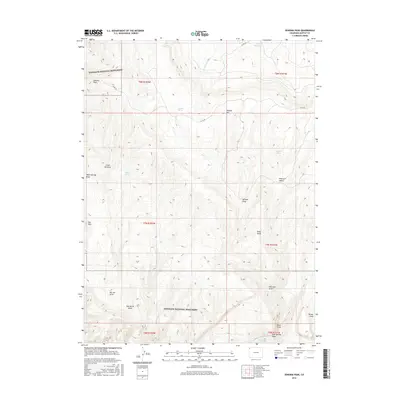
2016 Map of Zenobia Peak
USGS Topo · Published 2016About this map
Dinosaur National Monument encompasses large portions of this landscape, where high-elevation summits like Zenobia Peak and Douglas Mtn overlook a complex system of drainage basins. The arid environment is marked by essential water sources for cattle and wildlife, including Chicken Springs, Five Spring, and Cove Reservoir. The terrain transitions from the heights of the Ant Hills down into named basins such as Starvation Valley and Peterson Valley. Toward the southern edge, the Yampa River flows through the deep incisions of the plateau, while numerous ephemeral channels like Big Joe Draw and Holland Draw define the topography. Isolated landmarks such as Reds Knob stand as distinct points in a region primarily managed for conservation and ranching, accessible via rural routes like Co RD 60.
Find a feature on this map
30 named features on this map. Tap any name to fly to it.
Don’t see what you’re looking for? This feature index may not catch every label — zoom into the map to look around manually.
Map Details
Editions of this 2016 Zenobia Peak Map
This is the sole edition of this map. No revisions or reprints were ever made.
Other maps of this area

1907 · Rangely
USGS Topo · 1:125,000

1910 · Rangely
USGS Topo · 1:125,000

1954 · Hells Canyon
USGS Topo · 1:24,000

1954 · Canyon of Lodore South
USGS Topo · 1:24,000

1954 · Canyon of Lodore North
USGS Topo · 1:24,000

1954 · Vernal
USGS Topo · 1:250,000

1958 · Vernal
USGS Topo · 1:250,000

1960 · Vernal
USGS Topo · 1:250,000

1962 · Tanks Peak
USGS Topo · 1:24,000
1962 · Haystack Rock
USGS Topo · 1:24,000