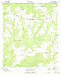
1973 Map of Zetto
USGS Topo · Published 1975About this map
Wesley Chapel and the small crossroads of Zetto center this southwest Georgia landscape in the early 1970s. The area is characterized by a high concentration of rural sanctuaries, including New Judson Ch, Antioch Ch, and Mt Zion Ch, which often serve as the primary markers of community across the undulating terrain. To the north, the Clay Lookout Tower stands as a sentinel over the timber and agricultural lands spanning the Randolph and Clay county line.
Find a feature on this map
30 named features on this map. Tap any name to fly to it.
Don’t see what you’re looking for? This feature index may not catch every label — zoom into the map to look around manually.
Map Details
Editions of this 1973 Zetto Map
This is the sole edition of this map. No revisions or reprints were ever made.
Other maps of this area

1953 · Dothan
USGS Topo · 1:250,000

1954 · Dothan
USGS Topo · 1:250,000

1955 · Dothan
USGS Topo · 1:250,000

1969 · Fort Gaines
USGS Topo · 1:24,000

1969 · Fort Gaines NE
USGS Topo · 1:24,000

1970 · Columbia NE
USGS Topo · 1:24,000
1973 · Coleman
USGS Topo · 1:24,000

1973 · Blakely North
USGS Topo · 1:24,000

1973 · Bancroft
USGS Topo · 1:24,000
1973 · Carnegie
USGS Topo · 1:24,000