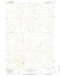
1966 Map of Zimmerman Buttes
USGS Topo · Published 1978About this map
Zimmerman Buttes dominate this high-desert landscape in the late 1960s, straddling the county line between Washakie and Hot Springs counties. The area is characterized by an intricate drainage system including Nowater Creek, Pistol Draw, and Zimmerman Draw, which cut through the arid terrain. While the landscape appears sparsely settled, the map reveals the infrastructure of resource management through features like Neiber Well, William Reservoir, and Election Reservoir. Landmark features like Potter Butte and Rocky Point serve as navigational anchors in this basin environment. The presence of a Pipeline and scattered Drill Holes underscores the region's importance to Wyoming's energy economy, while Zimmerman Springs highlights the rare natural water sources essential for life in the high plains.
Find a feature on this map
17 named features on this map. Tap any name to fly to it.
Don’t see what you’re looking for? This feature index may not catch every label — zoom into the map to look around manually.
Map Details
Editions of this 1966 Zimmerman Buttes Map
2 editions found
Other maps of this area

1945 · Kirby
USGS Topo · 1:62,500

1946 · Kirby
USGS Topo · 1:62,500

1955 · Thermopolis
USGS Topo · 1:250,000

1955 · Arminto
USGS Topo · 1:250,000

1958 · Thermopolis
USGS Topo · 1:250,000

1958 · Arminto
USGS Topo · 1:250,000

1960 · Coyote Hill
USGS Topo · 1:24,000

1960 · Packsaddle Creek
USGS Topo · 1:24,000

1960 · Red Hole
USGS Topo · 1:24,000

1962 · Thermopolis
USGS Topo · 1:250,000