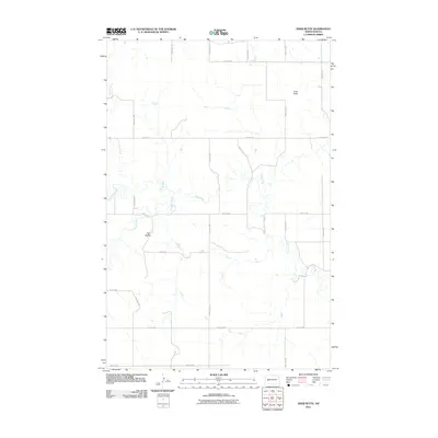
2011 Map of Ziner Butte
USGS Topo · Published 2011About this map
The winding Knife River meanders across this rural expanse of Dunn County, carving a path through the prairie landscape where significant elevation changes are marked by distinctive landmarks like Ziner Butte and the Twin Buttes. This 2011 survey illustrates a sparse ranching and agricultural region defined by its watercourses, including Crooked Creek and Stray Creek, which drain into the main river valley. A precise grid of section-line roads, such as 14th St SW and 95th Ave SW, reveals the geometric organization of the North Dakota landscape, providing access to the isolated high points and riparian corridors that have likely guided travel and land use in this part of the state for generations.
Find a feature on this map
18 named features on this map. Tap any name to fly to it.
Don’t see what you’re looking for? This feature index may not catch every label — zoom into the map to look around manually.
Map Details
Editions of this 2011 Ziner Butte Map
This is the sole edition of this map. No revisions or reprints were ever made.
Other maps of this area

1953 · Watford City
USGS Topo · 1:250,000

1957 · Watford City
USGS Topo · 1:250,000

1967 · Watford City
USGS Topo · 1:250,000

1973 · Marshall SW
USGS Topo · 1:24,000

1973 · Ziner Butte
USGS Topo · 1:24,000
1973 · Hirschville SW
USGS Topo · 1:24,000
1973 · Hirschville
USGS Topo · 1:24,000

1973 · Dunn Center
USGS Topo · 1:24,000

1973 · Emerson
USGS Topo · 1:24,000

1973 · Werner
USGS Topo · 1:24,000