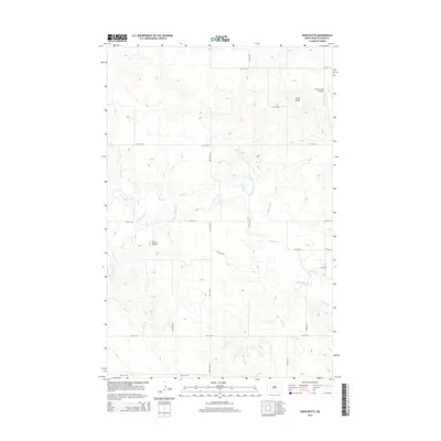
2014 Map of Ziner Butte
USGS Topo · Published 2014About this map
Knife River meanders across this rural landscape in Dunn County, serving as the primary drainage for a series of prairie creeks including Crooked Cr and Stray Cr. The terrain is defined by prominent topographical rises such as Ziner Butte in the northeast and Twin Buttes further south, providing significant landmarks in an otherwise open stretch of North Dakota. Modern infrastructure is represented by a strict grid of section roads, including 16th Ave SW and 12th St SW, which facilitate movement through this ranching and agricultural region. A notable specialized feature is the Sunset Strip Airport, located near the northern edge of the map, illustrating the importance of small-scale aviation for connectivity in this sparsely populated area.
Find a feature on this map
14 named features on this map. Tap any name to fly to it.
Don’t see what you’re looking for? This feature index may not catch every label — zoom into the map to look around manually.
Map Details
Editions of this 2014 Ziner Butte Map
This is the sole edition of this map. No revisions or reprints were ever made.
Other maps of this area

1953 · Watford City
USGS Topo · 1:250,000

1957 · Watford City
USGS Topo · 1:250,000

1967 · Watford City
USGS Topo · 1:250,000

1973 · Marshall SW
USGS Topo · 1:24,000

1973 · Ziner Butte
USGS Topo · 1:24,000
1973 · Hirschville SW
USGS Topo · 1:24,000
1973 · Hirschville
USGS Topo · 1:24,000

1973 · Dunn Center
USGS Topo · 1:24,000

1973 · Emerson
USGS Topo · 1:24,000

1973 · Werner
USGS Topo · 1:24,000