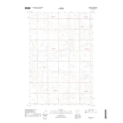
2017 Map of Ziner Butte
USGS Topo · Published 2017About this map
Ziner Butte rises above the open range of North Dakota's Badlands in this 2017 survey of Dunn County. The landscape is defined by its drainage systems, most notably the winding course of the Knife River, which is joined by Crooked Cr and Spring Cr. These waterways cut through a high prairie terrain marked by isolated landforms like Twin Buttes. Human settlement is sparse and dictated by the section-line road grid, which includes routes like 12th St SW and 95th Ave SW. The small community of Sunset Strip sits in the northeast corner, positioned near the highest elevations of the map. This edition reflects the contemporary rural layout of the region, where wide-scale agriculture and ranching are bounded by the Public Land Survey System townships, including t144n r94w and t143n r93w.
Find a feature on this map
24 named features on this map. Tap any name to fly to it.
Don’t see what you’re looking for? This feature index may not catch every label — zoom into the map to look around manually.
Map Details
Editions of this 2017 Ziner Butte Map
This is the sole edition of this map. No revisions or reprints were ever made.
Other maps of this area

1953 · Watford City
USGS Topo · 1:250,000

1957 · Watford City
USGS Topo · 1:250,000

1967 · Watford City
USGS Topo · 1:250,000

1973 · Marshall SW
USGS Topo · 1:24,000

1973 · Ziner Butte
USGS Topo · 1:24,000
1973 · Hirschville SW
USGS Topo · 1:24,000
1973 · Hirschville
USGS Topo · 1:24,000

1973 · Dunn Center
USGS Topo · 1:24,000

1973 · Emerson
USGS Topo · 1:24,000

1973 · Werner
USGS Topo · 1:24,000