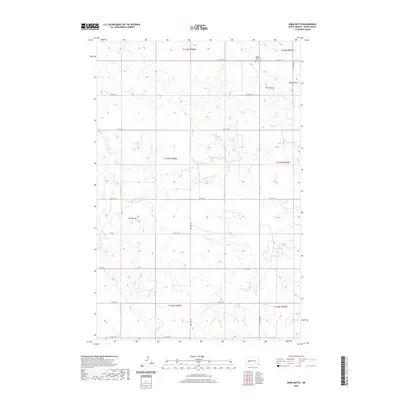
2020 Map of Ziner Butte
USGS Topo · Published 2020About this map
Ziner Butte and the double peaks of Twin Buttes anchor this portion of the North Dakota prairie in Dunn County. This section of the Great Plains is defined by the winding course of the Knife River, which is joined by local tributaries including Crooked Cr and Spring Cr. The land is partitioned by a strictly rectangular grid of section lines and rural roads, such as 16th St SW and 98th Ave SW, reflecting the enduring legacy of the Public Land Survey System. Human presence is sparse but concentrated at landmarks like the Vang Lutheran Cem near the northern boundary. The presence of Sunset Strip in the northeast suggests more recent local naming conventions atop the older agricultural and natural landscape.
Find a feature on this map
24 named features on this map. Tap any name to fly to it.
Don’t see what you’re looking for? This feature index may not catch every label — zoom into the map to look around manually.
Map Details
Editions of this 2020 Ziner Butte Map
This is the sole edition of this map. No revisions or reprints were ever made.
Other maps of this area

1953 · Watford City
USGS Topo · 1:250,000

1957 · Watford City
USGS Topo · 1:250,000

1967 · Watford City
USGS Topo · 1:250,000

1973 · Marshall SW
USGS Topo · 1:24,000

1973 · Ziner Butte
USGS Topo · 1:24,000
1973 · Hirschville SW
USGS Topo · 1:24,000
1973 · Hirschville
USGS Topo · 1:24,000

1973 · Dunn Center
USGS Topo · 1:24,000

1973 · Emerson
USGS Topo · 1:24,000

1973 · Werner
USGS Topo · 1:24,000