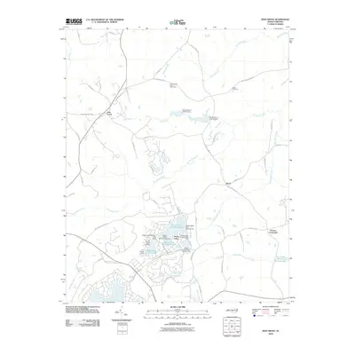
2010 Map of Zion Grove
USGS Topo · Published 2010About this map
Seven Lakes serves as the central hub of this Moore County landscape, characterized by a sophisticated system of reservoirs including Seven Lakes Lake Number Four and Seven Lakes Lake Number Two. Managed by structures such as the Seven Lakes Dam Number Three and the D C Ewing Dam, these water bodies define the residential and recreational character of the area near the Seven Lakes Airport. Further north, the Occoneechee Scout Reservation sits along the banks of Richland Creek, while the rural settlements of Zion Grove and Harris maintain their character at key crossroads. Local history is anchored by sites like Scott Cemetery and the distinctive Dead Man Curve Rd, illustrating the evolution of the road network through the headwaters of McLendons Creek and the Little River.
Find a feature on this map
64 named features on this map. Tap any name to fly to it.
Don’t see what you’re looking for? This feature index may not catch every label — zoom into the map to look around manually.
Map Details
Editions of this 2010 Zion Grove Map
This is the sole edition of this map. No revisions or reprints were ever made.
Other maps of this area

1942 · Troy
USGS Topo · 1:125,000

1948 · Southern Pines
USGS Topo · 1:62,500

1949 · West End
USGS Topo · 1:24,000

1949 · Jackson Springs
USGS Topo · 1:62,500

1950 · Southern Pines
USGS Topo · 1:24,000

1950 · Norman
USGS Topo · 1:24,000

1953 · Raleigh
USGS Topo · 1:250,000

1954 · Raleigh
USGS Topo · 1:250,000

1957 · Southern Pines
USGS Topo · 1:62,500
1957 · Southern Pines
USGS Topo · 1:24,000