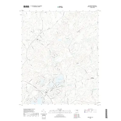
2019 Map of Zion Grove
USGS Topo · Published 2019About this map
Seven Lakes serves as the central hub of this Moore County landscape, where modern residential development intertwines with the area's complex drainage network. The landscape is defined by the winding paths of McLendons Creek and the Little River, which carve through the undulating terrain near Saddle Ridge. Small, older nodes of settlement such as Harris, Zion Grove, and Thomas Crossroads are connected by a web of rural roads, including Bensalem Church Rd and Old Carthage Rd. This modern survey illustrates the transition from traditional Sandhills farming and forestry to recreational land use, evidenced by the clustered waters of Seven Lakes Number One through Number Four and the Pine Lakes Shooting Preserve Lake. For those researching local families, the presence of the Scott Cem provides a specific point of genealogical interest in the northern uplands.
Find a feature on this map
116 named features on this map. Tap any name to fly to it.
Don’t see what you’re looking for? This feature index may not catch every label — zoom into the map to look around manually.
Map Details
Editions of this 2019 Zion Grove Map
This is the sole edition of this map. No revisions or reprints were ever made.
Other maps of this area

1942 · Troy
USGS Topo · 1:125,000

1948 · Southern Pines
USGS Topo · 1:62,500

1949 · West End
USGS Topo · 1:24,000

1949 · Jackson Springs
USGS Topo · 1:62,500

1950 · Southern Pines
USGS Topo · 1:24,000

1950 · Norman
USGS Topo · 1:24,000

1953 · Raleigh
USGS Topo · 1:250,000

1954 · Raleigh
USGS Topo · 1:250,000

1957 · Southern Pines
USGS Topo · 1:62,500
1957 · Southern Pines
USGS Topo · 1:24,000