Old Maps of Colbert County, Alabama for Academic Research
Study the evolution of Colbert County with 189 high-resolution historic maps. Whether you're teaching, researching, or modeling changes in land use, these maps provide essential visual documentation of urban, environmental, and geographic change.
- Analyze long-term change: Track patterns in development, transportation, and natural features.
- Ideal for environmental or urban studies: Support academic projects with primary historical map data.
- Use in the classroom or lab: Educators and researchers rely on these maps to bring historical context to life.
These maps are a powerful tool for teaching, research, and visualizing how Colbert County has changed over the decades.
Colbert County, AL maps
(189)- 1911 Map of Iuka
 1911 Iuka1911 Print · USGSThe tri-state border region of Mississippi, Alabama, and Tennessee is captured here at the peak of the river-landing era. Genealogists can trace family connections through numerous river access points like Shellbank Landing and rural landmarks such as Salem Church and Jackson Ridge School.2 unique versions available
 - 1914 Map of Iuka
 1914 Iuka1914 Print · USGSThe Tennessee River valley at the Mississippi and Alabama border was a busy network of landings and rail junctions in the early twentieth century. Researchers can trace riverfront life at Eastport Landing or locate rural family landmarks like Salem Church and Guthrie School.4 unique versions available
 - 1914 Map of Rogersville
 1914 Rogersville1914 Print · USGSBefore the Tennessee River was dammed and widened, this area supported a dense network of river-linked communities. Trace the legacy of early families through landmarks like Lambs Ferry, Mitchell Mill, and the many rural sites like Sweet Gum Church.
 - 1914 Map of Muscle Shoals
 1914 Muscle Shoals1914 Print · USGSThe Tennessee River and its complex shoals define the Shoals region in the years before major damming projects. Trace the Muscle Shoals Canal and find landmarks like St Florian, Mars Hill School, and Lock No 6.
 - 1916 Map of Muscle Shoals
 1916 Muscle Shoals1916 Print · USGSThe Tennessee River corridor around Florence and Sheffield appears here in the years before dam construction altered the valley forever. Researchers can trace historic river crossings like Goose Shoals Ford, early navigation locks, and vanished community hubs such as Big Cut Hines PO.2 unique versions available
 - 1916 Map of Rogersville
 1916 Rogersville1916 Print · USGSLauderdale County was a landscape of river-driven commerce and rural crossroads in the decade before the Tennessee River was transformed. Researchers can trace ancestral locations through dozens of named sites like Lambs Ferry, Hurricane Church, and the Muscle Shoals Canal.2 unique versions available
 - 1924 Map of Tuscumbia
 1924 Tuscumbia1924 Print · USGSNorth Alabama in the mid-twenties shows a landscape of river-oriented commerce and upland farming before the modern reservoir system. Genealogists can locate family landmarks from Leighton to Russellville, including Clements Mill, Ligon Springs, and the Morning Star School.2 unique versions available
 - 1924 Map of Gravelly Springs
 1924 Gravelly Springs1924 Print · USGSLauderdale County at the edge of the Tennessee River reveals a vibrant rural society in the mid-twenties, centered on the river and the rail line. Researchers can trace the heritage of vanished landmarks like Lyle Academy, the Colbert Shoals Canal, and the Oakland School (Colored).2 unique versions available
 - 1925 Map of Barton, 1954 Print
 1925 Barton1954 Print · USGSColbert and Franklin Counties are captured here in the mid-twenties, showing a landscape of river-valley agriculture and rugged uplands. Researchers can locate dozens of rural landmarks, from the rail stop at Barton to country schools like Whiteoak Sch and Jonesboro Sch.
 - 1926 Map of Tuscumbia
 1926 Tuscumbia1926 Print · USGSThe Tennessee River valley and the northern ridges of the Black Warrior highlands appear here in the mid-twenties. Genealogists can trace family sites like Campbell Settlement or early centers such as Spring Valley Sta and Atepost.3 unique versions available
 - 1926 Map of Barton
 1926 Barton1926 Print · USGSNorthwest Alabama's river hills and rail corridors come alive in this mid-twenties survey of Colbert and Franklin Counties. Genealogists can trace family roots through numerous local landmarks like Evening Shade Church, Back Creek School, and the settlement at Frankfort.
 - 1926 Map of Gravelly Springs
 1926 Gravelly Springs1926 Print · USGSNorthwest Alabama is seen here in the mid-twenties, when the river and rail lines dictated the rhythm of Lauderdale and Colbert counties. Genealogists can locate family landmarks like Lyle Academy, Youngs Store, and the Colbert Shoals Canal.2 unique versions available
 - 1929 Map of Barton
 1929 Barton1929 Print · USGSIn the late 1920s, this area of Northwest Alabama was a patchwork of creek-side farms and small railroad stops. Researchers can trace the layout of early rural life through community hubs like Barton, Crooked Oak, and the Evening Shade Ch school and church.3 unique versions available
 - 1935 Map of Cherokee
 1935 Cherokee1935 Print · USGSNorthern Alabama is captured in the mid-1930s as the TVA prepares to inundate the valley for the Pickwick Landing Reservoir. Genealogists and historians can trace family-named sites like Perkins Cem, Moontown Ch, and the town of Cherokee.
 - 1935 Map of Wright
 1935 Wright1935 Print · USGSLauderdale County and the Tennessee River are shown here in the mid-1930s during the early development of the Tennessee Valley Authority. Genealogists can trace early landmarks such as Williams Chapel, Youngs Store, and the historic Nathez Trace.
 - 1935 Map of Pleasant Site
 1935 Pleasant Site1935 Print · USGSNorth Alabama rural life is captured here in the mid-1930s along the boundary of Colbert and Franklin Counties. Genealogists and historians can trace family roots through sites like Bates Hill Ch, Harmony Cem, and the settlement at Pogo.
 - 1936 Map of Russellville
 1936 Russellville1936 Print · USGSFranklin County in the mid-1930s shows a landscape of small agricultural settlements and nascent industrial infrastructure along the Southern Railway. Genealogists can trace family landmarks and schools like Mountain Star Sch, the Iron Mine (Abandoned), and Osborn Cem.
 - 1936 Map of Margerum
 1936 Margerum1936 Print · USGSThe Alabama-Mississippi borderland is captured during a time of immense change as the Tennessee Valley Authority prepares for the Pickwick Landing Reservoir. Local historians can trace family roots through sites like Carytown Ch, Crenshaw Cem, and the settlement of Margerum.
 - 1936 Map of Belmont
 1936 Belmont1936 Print · USGSNortheast Mississippi at the height of the New Deal era features the growth of Belmont and the establishment of Tishomingo State Park. You can trace rural schoolhouses and family cemeteries like Burnt Mill Sch and Russell Cem along the Illinois Central Railroad.
 - 1936 Map of Waterloo
 1936 Waterloo1936 Print · USGSThe Tennessee River border between Alabama and Mississippi is captured here during the mid-1930s transition to a dammed waterway. Genealogists and historians can locate community landmarks like Fords Mill Ch, the Riverton Ferry, and Watkins Cem.
 - 1936 Map of Frankfort
 1936 Frankfort1936 Print · USGSNorthwest Alabama in the mid-1930s reveals a patchwork of small creek-side settlements and rural schools along the Chickasaw Boundary. Researchers can trace old family sites and crossroads like Frankfort, Hovaters Mill, and the Burnt Church Cem.
 - 1936 Map of Pleasant Grove
 1936 Pleasant Grove1936 Print · USGSNorthwestern Alabama's borderlands are captured here in the mid-1930s, showing a rural landscape of scattered homesteads and creek-side communities. Genealogists can trace family lines through numerous sites like Tick Hill Ch, Bond Cem, and the old school at Posey Sch.
 - 1936 Map of Pride
 1936 Pride1936 Print · USGSColbert County sits at a crossroads of river and rail during the mid-1930s expansion of the TVA system. Genealogists and historians can trace family-named landmarks like Hesters Store and Kellar Quarry Landing alongside rural community hubs like Nazare Ch and Barton Sch.
 - 1936 Map of Barton
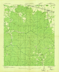 1936 Barton1936 Print · USGSColbert County's rugged southern uplands are captured here in the mid-1930s, showing the intersection of new Tennessee Valley Authority power lines with traditional mountain life. Genealogists can locate family names at Barton Cem, Newsom Spring Sch, and the isolated Mt Zion Ch.
 - 1936 Map of Wheeler Dam
 1936 Wheeler Dam1936 Print · USGSThe Tennessee River valley was undergoing a massive transformation in the mid-1930s as the TVA reservoirs filled. Local researchers can trace the early layout of Wheeler Dam Village and locate family landmarks like Fosters Mill, Center Star Sch, and Houstontown.
Showing maps 1-25 of 189
Top cities of Colbert County
- Muscle Shoals historical maps
- Sheffield historical maps
- Tuscumbia historical maps
- Littleville historical maps
- Cherokee historical maps
- Leighton historical maps
Frequently asked questions
- What are the different types of historical maps available for Colbert County?
- What is the oldest map of Colbert County?
- Where can I purchase historical maps of Colbert County for my home or office?
- Where can I download high-res historical maps of Colbert County?
- Are there historical topographic maps available for Colbert County?
- Is there historical aerial imagery available for Colbert County?
- Where are historical maps of Colbert County sourced from?