Old Maps of Jackson County, Alabama for Hiking & Exploration
Hike through history with 256 historic maps of Jackson County. Explore old trails, ghost towns, and forgotten backroads — perfect for outdoor adventurers and local explorers.
- Rediscover forgotten places: Map out old mining camps, roads, and footpaths that no longer exist on modern maps.
- Layer with modern tools: Combine with LiDAR or satellite views to plan hikes through historical terrain.
- Made for exploration: Popular among hikers, overlanders, and local history lovers.
Use these maps to find adventure and explore the hidden past of Jackson County.
Jackson County, AL maps
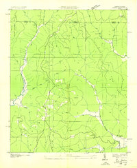
(256)- 1885 Map of Gadsden
 1885 Gadsden1885 Print · USGSNortheast Alabama in the mid-1880s was a landscape of river-side landings and emerging rail towns. Genealogists and historians can trace the early foundations of Guntersville and Gadsden while locating rural landmarks like Hillian Store, Cottonville, and Law Landing.
 - 1886 Map of Stevenson
 1886 Stevenson1886 Print · USGSNortheast Alabama at the peak of the railroad era shows a landscape tied to the river and the rails. Genealogists can trace family landmarks like Coffey's Store or locate river crossings such as Caperton Ferry and Snodgrass Ferry.
 - 1888 Map of Gadsden
 1888 Gadsden1888 Print · USGSNorth Alabama's river valleys and plateau lands are captured here in the late nineteenth century as the region transitioned from river landings to rail transport. Researchers can locate early post offices and commerce centers like Hillian's Store, Guntersville, and the ferry at Ft Deposit.
 - 1888 Map of Scottsboro
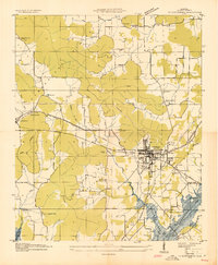
 1888 Scottsboro1888 Print · USGSNortheast Alabama is shown in the late nineteenth century as a land of steep plateaus and vital river crossings. Genealogists and researchers can trace the early rail-and-river economy through family landmarks like Caldwell's Ferry and the Bell Factory textile site.
 - 1892 Map of Scottsboro
 1892 Scottsboro1892 Print · USGSJackson County and the Tennessee River valley are captured here in the late nineteenth century, just as railroads began to reshape local commerce. Genealogists can trace family-named sites like Owen's Cross Roads, Carrick Mill, and Larkin Landing.5 unique versions available
 - 1892 Map of Stevenson
 1892 Stevenson1892 Print · USGSNortheast Alabama and the Tennessee border in the 1890s reveal a landscape of mountain coves and vital river crossings. Genealogists and historians can trace rail junctions at Stevenson, river landings like Coffey's Ferry, and landmarks like Nickajack Cave.
 - 1892 Map of Gadsden
 1892 Gadsden1892 Print · USGSNorth Alabama's river-and-rail economy is captured here in the late nineteenth century as Guntersville and Gadsden emerge as regional hubs. Genealogists and historians can trace the routes of the Birmingham Mineral R. R. or locate old community centers like Cottonville and Mt Zion.
 - 1893 Map of Fort Payne
 1893 Fort Payne1893 Print · USGSNortheast Alabama is shown here in the late nineteenth century as the rail network transformed the valley floor. Genealogists and historians can trace family-named crossroads like Hoge's X Roads and vital river crossings including Coker Ferry and Sewell Ferry.
 - 1895 Map of Stevenson
 1895 Stevenson1895 Print · USGSThe Tennessee River valley and surrounding plateaus were a hub of rail and river commerce at the close of the century. Genealogists can trace family crossings at Island Creek Ferry or locate old communities like Bellefonte, Stevenson, and Valley Head.6 unique versions available
 - 1895 Map of Gadsden
 1895 Gadsden1895 Print · USGSNortheast Alabama at the close of the century was a landscape of river landings and mountain gaps where the Tennessee River met growing rail hubs. Genealogists can trace family holdings near Hillian Store, Cottonville, and the remote heights of Lookout Mountain.
 - 1898 Map of Fort Payne, 1964 Print
 1898 Fort Payne1964 Print · USGSDeKalb and Cherokee counties in the late 1890s are defined by the steep ridges of Lookout Mountain and a bustling network of river ferries. Genealogists can trace family roots through numerous river crossings like Hardwick Ferry and early industrial sites such as Sloan Mill or Abernathy Mill.
 - 1900 Map of Fort Payne
 1900 Fort Payne1900 Print · USGSNortheast Alabama is defined by its deep ridges and river valleys in the late nineteenth century. Researchers can trace the era's ferry network across the Coosa River and find old family-run landmarks like Wagners Store and Santy Mills.6 unique versions available
 - 1903 Map of Gadsden
 1903 Gadsden1903 Print · USGSNorthern Alabama in the late nineteenth century centers on the busy Tennessee River corridor and its surrounding ridges. Trace old family sites and transport hubs like Hillian Store, Lovelace Landing, and the Mt Zion church.4 unique versions available
 - 1936 Map of Trenton
 1936 Trenton1936 Print · USGSThe Georgia and Alabama borderlands are captured here in the mid-1930s as mountain life met the era's emerging highway and rail networks. Genealogists can locate family landmarks like Sand Mtn Academy, Hanna Cem, and the community of Rising Fawn.
 - 1936 Map of Scottsboro
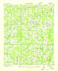
 1936 Scottsboro1936 Print · USGSJackson County is captured during the mid-1930s TVA transformations, showing the valley just before the reservoir waters rose. Trace family roots at Cedar Hill Cem, Larkinsville, or the curiously named House of Happiness Sch.
 - 1936 Map of Ider
 1936 Ider1936 Print · USGSThe plateau of De Kalb and Jackson counties is captured here in the mid-1930s as a network of crossroads and family farms. Local historians can trace family roots through sites like Yorks Mill, Pilgrims Home Ch, and the Fuller Cem.
 - 1936 Map of Shellmound
 1936 Shellmound1936 Print · USGSThe tristate borderlands of Georgia, Alabama, and Tennessee are captured here in the mid-1930s before the flooding of the Guntersville Reservoir. Genealogists can locate family landmarks like Stephens Cem, Burnett Chapel, and several local schools like Poplar Spring Sch.
 - 1936 Map of King Cove
 1936 King Cove1936 Print · USGSThe Alabama-Tennessee borderlands appear here in the mid-1930s, showing a landscape of high ridges and isolated mountain coves. Researchers can locate family landmarks like Crowell Cem and Maxwell Cem or rural centers like Howard Hill Sch.
 - 1936 Map of Bridgeport
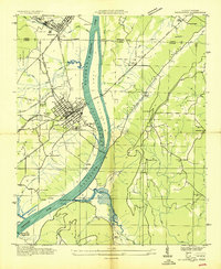 1936 Bridgeport1936 Print · USGSBridgeport and the Tennessee River valley are seen here in the mid-1930s, just as the proposed Guntersville Reservoir was set to reshape the riverbank. Genealogists and historians can trace family locations near Richard City, locate the Island Creek Ferry, and find early sites like Mc Daniel Chapel and Concord Sch.
 - 1936 Map of Wannville
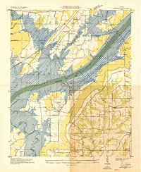
 1936 Wannville1936 Print · USGSJackson County landscape in the mid-1930s documents the Tennessee Valley before the rising waters of the Proposed Guntersville Reservoir. Genealogists can trace local landmarks like Womacks Store, the Rosenwald Sch, and the Pauper Cem near Poor House Mountain.
 - 1936 Map of Langston
 1936 Langston1936 Print · USGSJackson and Marshall counties are captured during the 1930s as the Tennessee Valley Authority prepared to flood the valley. Local historians can trace the original landscape around Langston before the reservoir arrived, including Larkins Ferry, Kelley Cem, and St Joseph Sch.
 - 1936 Map of Flat Rock
 1936 Flat Rock1936 Print · USGSSand Mountain in the mid-thirties remains a landscape of high plateaus and remote community centers. Genealogists can trace family names at Smith Cem and Cooley Cem or locate the rural crossroads at Christian Home and Flat Rock.
 - 1936 Map of Hollytree
 1936 Hollytree1936 Print · USGSJackson County, Alabama, was a landscape of mountain coves and limestone sinks in the mid-1930s. Genealogists and hikers can trace old family footprints at Hollytree, locate rural landmarks like Pleas Mount Ch, or explore the terrain around Aladdin Cave and Bingham Narrows.
 - 1936 Map of Mud Creek
 1936 Mud Creek1936 Print · USGSJackson County in the mid-1930s shows a landscape of mountain plateaus and creek-side settlements. Genealogists can locate family landmarks like Bynum Cem, Fairfield Sch, and the community of Tupelo.
 - 1936 Map of Hytop
 1936 Hytop1936 Print · USGSThe high plateau of Jackson County is captured here in the mid-1930s as the Tennessee Valley Authority began mapping the Cumberland region. Genealogists and historians can trace family-named landmarks and rural hubs like Hytop, the Walnut Grove Sch, and Jericho.
Showing maps 1-25 of 256
Top cities of Jackson County
- Scottsboro historical maps
- Bridgeport historical maps
- Stevenson historical maps
- Hollywood historical maps
- Skyline historical maps
- Section historical maps
See more
Frequently asked questions
- What are the different types of historical maps available for Jackson County?
- What is the oldest map of Jackson County?
- Where can I purchase historical maps of Jackson County for my home or office?
- Where can I download high-res historical maps of Jackson County?
- Are there historical topographic maps available for Jackson County?
- Is there historical aerial imagery available for Jackson County?
- Where are historical maps of Jackson County sourced from?