1930s Maps of Jackson County, Alabama
Explore 27 historic maps of Jackson County from the 1930s. These maps offer a rare glimpse into what life looked like during the 1930s — showing old roads, neighborhoods, homes, and landmarks that have changed or disappeared over time.
Whether you're researching your family's past, planning a metal detecting trip, or studying how Jackson County's landscape evolved across the 1930s, these high-resolution maps are a powerful tool for exploring the history of this region.
- Focus on a specific era: All maps on this page are from the 1930s, giving you a focused view of this time period.
- See what’s changed: Compare century-old streets, trails, and buildings to today's modern landscape using overlays and satellite layers.
- Research with precision: Use these maps for genealogy, historical research, land use analysis, or educational projects.
- View, download, or print: Maps are fully viewable online in high resolution, and can be downloaded or printed for your own records.
Start exploring Jackson County's history through authentic maps from the 1930s. This is your window into the past.
Jackson County, AL maps
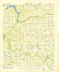
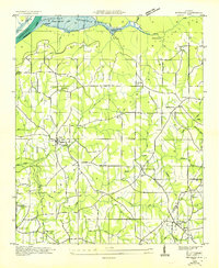
(27)- 1936 Map of Trenton
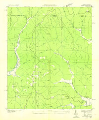
 1936 Trenton1936 Print · USGSThe Georgia and Alabama borderlands are captured here in the mid-1930s as mountain life met the era's emerging highway and rail networks. Genealogists can locate family landmarks like Sand Mtn Academy, Hanna Cem, and the community of Rising Fawn.
 - 1936 Map of Scottsboro
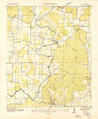
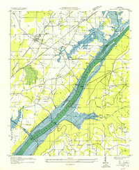
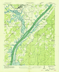
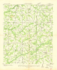
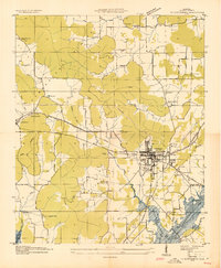 1936 Scottsboro1936 Print · USGSJackson County is captured during the mid-1930s TVA transformations, showing the valley just before the reservoir waters rose. Trace family roots at Cedar Hill Cem, Larkinsville, or the curiously named House of Happiness Sch.
 - 1936 Map of Ider
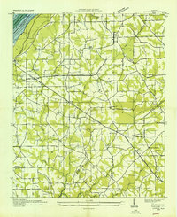
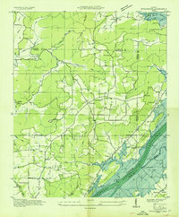
 1936 Ider1936 Print · USGSThe plateau of De Kalb and Jackson counties is captured here in the mid-1930s as a network of crossroads and family farms. Local historians can trace family roots through sites like Yorks Mill, Pilgrims Home Ch, and the Fuller Cem.
 - 1936 Map of Shellmound
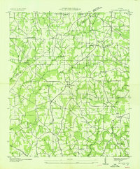
 1936 Shellmound1936 Print · USGSThe tristate borderlands of Georgia, Alabama, and Tennessee are captured here in the mid-1930s before the flooding of the Guntersville Reservoir. Genealogists can locate family landmarks like Stephens Cem, Burnett Chapel, and several local schools like Poplar Spring Sch.
 - 1936 Map of King Cove
 1936 King Cove1936 Print · USGSThe Alabama-Tennessee borderlands appear here in the mid-1930s, showing a landscape of high ridges and isolated mountain coves. Researchers can locate family landmarks like Crowell Cem and Maxwell Cem or rural centers like Howard Hill Sch.
 - 1936 Map of Bridgeport
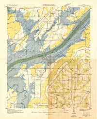
 1936 Bridgeport1936 Print · USGSBridgeport and the Tennessee River valley are seen here in the mid-1930s, just as the proposed Guntersville Reservoir was set to reshape the riverbank. Genealogists and historians can trace family locations near Richard City, locate the Island Creek Ferry, and find early sites like Mc Daniel Chapel and Concord Sch.
 - 1936 Map of Wannville
 1936 Wannville1936 Print · USGSJackson County landscape in the mid-1930s documents the Tennessee Valley before the rising waters of the Proposed Guntersville Reservoir. Genealogists can trace local landmarks like Womacks Store, the Rosenwald Sch, and the Pauper Cem near Poor House Mountain.
 - 1936 Map of Langston
 1936 Langston1936 Print · USGSJackson and Marshall counties are captured during the 1930s as the Tennessee Valley Authority prepared to flood the valley. Local historians can trace the original landscape around Langston before the reservoir arrived, including Larkins Ferry, Kelley Cem, and St Joseph Sch.
 - 1936 Map of Flat Rock
 1936 Flat Rock1936 Print · USGSSand Mountain in the mid-thirties remains a landscape of high plateaus and remote community centers. Genealogists can trace family names at Smith Cem and Cooley Cem or locate the rural crossroads at Christian Home and Flat Rock.
 - 1936 Map of Hollytree
 1936 Hollytree1936 Print · USGSJackson County, Alabama, was a landscape of mountain coves and limestone sinks in the mid-1930s. Genealogists and hikers can trace old family footprints at Hollytree, locate rural landmarks like Pleas Mount Ch, or explore the terrain around Aladdin Cave and Bingham Narrows.
 - 1936 Map of Mud Creek
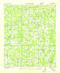
 1936 Mud Creek1936 Print · USGSJackson County in the mid-1930s shows a landscape of mountain plateaus and creek-side settlements. Genealogists can locate family landmarks like Bynum Cem, Fairfield Sch, and the community of Tupelo.
 - 1936 Map of Hytop
 1936 Hytop1936 Print · USGSThe high plateau of Jackson County is captured here in the mid-1930s as the Tennessee Valley Authority began mapping the Cumberland region. Genealogists and historians can trace family-named landmarks and rural hubs like Hytop, the Walnut Grove Sch, and Jericho.
 - 1936 Map of Grant
 1936 Grant1936 Print · USGSAs the mid-1930s brought the Tennessee Valley Authority to Marshall County, this area balanced its mountain heritage with new river developments. Genealogists and researchers can trace family landmarks like Butlers Mill, Fishtrap Ford, and the DAR Sch.
 - 1936 Map of Dutton
 1936 Dutton1936 Print · USGSSand Mountain and the Tennessee River valley appear here in the mid-thirties just as the landscape began to change. Trace the old community footprints of Dutton and Macedonia or locate family landmarks like Happy Hill Ch and Patterson Sch.
 - 1936 Map of Sylvania
 1936 Sylvania1936 Print · USGSSand Mountain's rural plateau comes to life in the mid-1930s, showing a landscape of family farms and community centers. Genealogists can trace family footprints at Bowman Crossroads, Mahan Sch, or the Dean Chapel Cem.
 - 1936 Map of Grove Oak
 1936 Grove Oak1936 Print · USGSDeKalb and Marshall counties are captured in the mid-1930s as the Tennessee Valley Authority began transforming the river landscape. Genealogists can locate numerous rural landmarks like Prospect Ch, Old Beulah Ch, and High Falls Bridge.
 - 1936 Map of Princeton
 1936 Princeton1936 Print · USGSThe Paint Rock River valley in the mid-1930s was a network of cove-based farmsteads and upland mines. Genealogy researchers can locate family sites near Princeton, the Camp Ground Ch, and coal operations at Jacobs Mine.
 - 1936 Map of Lim Rock
 1936 Lim Rock1936 Print · USGSJackson County in the mid-1930s shows a landscape of rail-side towns and mountain hollows as the new reservoir begins to take shape. Researchers can trace ancestral roots through sites like Lim Rock Sch, Wininger, and the Bethlehem Ch.
 - 1936 Map of Hollywood
 1936 Hollywood1936 Print · USGSJackson County is captured during the mid-thirties as the Tennessee Valley Authority prepared for the flooding of the Guntersville Reservoir. You can trace the old paths of the Lee Highway, locate the Wheeler Mine, or find family names at Phillip Cem and Bellefonte Cem.
 - 1936 Map of Stevenson
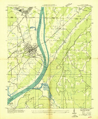
 1936 Stevenson1936 Print · USGSJackson County is captured here just as the Tennessee Valley Authority began reshaping the Tennessee River valley in the mid-1930s. Genealogists can locate family landmarks like Caperton Ferry and Rudders Chapel before the Proposed Guntersville Reservoir transformed the local landscape.
 - 1936 Map of Swearengin
 1936 Swearengin1936 Print · USGSMarshall and Jackson counties appear here just as the Tennessee Valley Authority began transforming the region in the mid-1930s. Genealogists and historians can trace family locations through sites like Old Barclay Mill, the State Prison Camp C, and the Zions Rest Cem before the reservoir waters rose.
 - 1936 Map of Henagar
 1936 Henagar1936 Print · USGSDeKalb and Jackson counties were undergoing significant change in the mid-1930s as the Tennessee Valley Authority developed the region. Researchers can locate early educational and religious sites including Chalybeate Springs Sch, Friendship Ch, and the settlement of Pisgah.
 - 1936 Map of Doran Cove
 1936 Doran Cove1936 Print · USGSJackson County and the Tennessee River are captured here in the mid-1930s as the Tennessee Valley Authority planned the region's modernization. Researchers can locate family landmarks like the Rosenwald Sch, Widows Bar Lock and Dam, and Bonaventure Cem.
 - 1936 Map of Eureka
 1936 Eureka1936 Print · USGSThe Alabama-Tennessee borderlands appear here in the mid-1930s, showing a landscape of deep coves and plateau summits. Genealogists can trace family landmarks like Allison Mill, Bell Store, and the John Sumach Reservation along the creek bottoms.
 - 1936 Map of Fyffe
 1936 Fyffe1936 Print · USGSDeKalb County and the Sand Mountain plateau are captured here during the mid-1930s, showing a landscape of tightly-knit rural communities. You can trace early creek crossings like Old Sauty Mill Bridge and locate family landmarks such as Lusk Chapel Ch and Ten Broeck.
Showing maps 1-25 of 27
Top cities of Jackson County
- Scottsboro historical maps
- Bridgeport historical maps
- Stevenson historical maps
- Hollywood historical maps
- Skyline historical maps
- Section historical maps
See more
Frequently asked questions
- What are the different types of historical maps available for Jackson County?
- What is the oldest map of Jackson County?
- Where can I purchase historical maps of Jackson County for my home or office?
- Where can I download high-res historical maps of Jackson County?
- Are there historical topographic maps available for Jackson County?
- Is there historical aerial imagery available for Jackson County?
- Where are historical maps of Jackson County sourced from?