1940s Maps of Washington County, Alabama
Explore 10 historic maps of Washington County from the 1940s. These maps offer a rare glimpse into what life looked like during the 1940s — showing old roads, neighborhoods, homes, and landmarks that have changed or disappeared over time.
Whether you're researching your family's past, planning a metal detecting trip, or studying how Washington County's landscape evolved across the 1940s, these high-resolution maps are a powerful tool for exploring the history of this region.
- Focus on a specific era: All maps on this page are from the 1940s, giving you a focused view of this time period.
- See what’s changed: Compare century-old streets, trails, and buildings to today's modern landscape using overlays and satellite layers.
- Research with precision: Use these maps for genealogy, historical research, land use analysis, or educational projects.
- View, download, or print: Maps are fully viewable online in high resolution, and can be downloaded or printed for your own records.
Start exploring Washington County's history through authentic maps from the 1940s. This is your window into the past.
Washington County, AL maps
(10)- 1942 Map of Deer Park, 1966 Print
 1942 Deer Park1966 Print · USGSCrossing the state line in the 1940s, this area is defined by the river systems and early rail lines of the Piney Woods. Genealogists can locate family landmarks like Turners Store, Stalworth Camp, and small rural schools including McCann Sch.
 - 1943 Map of Deer Park
 1943 Deer Park1943 Print · USGSSouthwestern Alabama near the Mississippi border is shown here during the early 1940s, centered on the logging and rail corridors of the Escatawpa River. Researchers can locate rural landmarks like Stalworth Camp, the Mississippi and Alabama RR, and several churches including Shiloh Ch.2 unique versions available
 - 1943 Map of Choctaw Bluff, 1958 Print
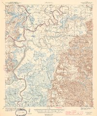
 1943 Choctaw Bluff1958 Print · USGSSouthwestern Alabama during the 1940s is shaped by the meeting of the Tombigbee River and Alabama River. Researchers can trace old river landings like Dixie Ldg and find the historic Grave of Red Eagle (Weatherford).2 unique versions available
 - 1943 Map of Tensaw, 1958 Print
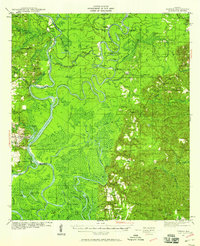 1943 Tensaw1958 Print · USGSBaldwin County at the height of the river-landing era is detailed here through its complex bayous and plantations. Genealogists can locate family names at Lancaster Cem and trace rural life at Fleming Sch or Davis Ldg.2 unique versions available
 - 1943 Map of Citronelle, 1960 Print
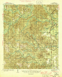
 1943 Citronelle1960 Print · USGSThe pine hills of northern Mobile County are captured here in the early 1940s, just as the river-and-rail economy matured. Genealogists can locate family landmarks like St Thomas Cem, Sims Chapel, and the Weaver Community House.2 unique versions available
 - 1943 Map of McIntosh, 1972 Print
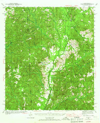
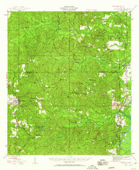
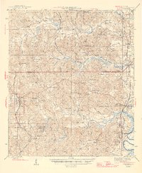
 1943 McIntosh1972 Print · USGSMcIntosh and the Piney Woods of Washington County are shown here during the early 1940s, highlighting a landscape of timber, rails, and small settlements. Researchers can trace family roots through landmarks like Harris Cem, Fields Sch, and Pine Lodge Ch.
 - 1944 Map of McIntosh
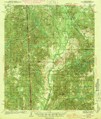
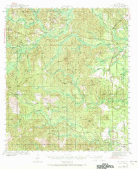
 1944 McIntosh1944 Print · USGSWashington County during the early 1940s is captured here in detail, showing the rural communities of the Alabama pine belt. Genealogists can trace family landmarks like Harris Cem and the small country congregations at Bethel Ch and Pine Lodge Ch.2 unique versions available
 - 1944 Map of Tensaw
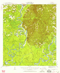
 1944 Tensaw1944 Print · USGSThe Alabama and Mobile River deltas are captured here during the mid-forties, showing a landscape defined by intricate waterways and rural landings. Researchers can trace historic river access at Old Ft Stoddard Mt Vernon Ldg or locate family sites like Lancaster Cem and Stockton Sch.3 unique versions available
 - 1946 Map of Citronelle
 1946 Citronelle1946 Print · USGSCoastal Alabama's pine-belt communities and rail networks are captured here in the mid-1940s as industry and infrastructure expanded. Researchers can locate specific local landmarks like Cherokee Mineral Sprs, Cedar Creek State Park, and the Fairford Fire Tower.2 unique versions available
 - 1946 Map of Choctaw Bluff
 1946 Choctaw Bluff1946 Print · USGSThe river-bottom country of southwest Alabama is shown here just after the war, where the mighty Tombigbee and Alabama rivers meet. Researchers can trace historic river landings like Oven Bluff or find the Grave of Red Eagle (Weatherford) near the confluence.2 unique versions available
End of results
Showing maps 1-10 of 10
Top cities of Washington County
- Chatom historical maps
- Leroy historical maps
- Millry historical maps
- Calvert historical maps
- McIntosh historical maps
Frequently asked questions
- What are the different types of historical maps available for Washington County?
- What is the oldest map of Washington County?
- Where can I purchase historical maps of Washington County for my home or office?
- Where can I download high-res historical maps of Washington County?
- Are there historical topographic maps available for Washington County?
- Is there historical aerial imagery available for Washington County?
- Where are historical maps of Washington County sourced from?