1943 Map of Choctaw Bluff
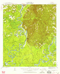
USGS Topo · Published 1958This historical map portrays the area of Choctaw Bluff in 1943, primarily covering Clarke County as well as portions of Washington County, Baldwin County, and Monroe County. Featuring a scale of 1:62500, this map provides a highly detailed snapshot of the terrain, roads, buildings, counties, and historical landmarks in the Choctaw Bluff region at the time. Published in 1958, it is one of 2 known editions of this map due to revisions or reprints.
Find a feature on this map
107 named features on this map. Tap any name to fly to it.
Don’t see what you’re looking for? This feature index may not catch every label — zoom into the map to look around manually.
Map Details
Editions of this 1943 Choctaw Bluff Map
2 editions found
Historical Maps of Washington County Through Time
30 maps found

1943 Choctaw Bluff
Clarke County, AL

1946 Choctaw Bluff
Clarke County, AL

1972 Chance
Clarke County, AL

1972 Gainestown
Clarke County, AL

1972 Suggsville
Clarke County, AL

1972 Tattlersville
Clarke County, AL

1972 Woods Bluff
Clarke County, AL

1973 Fulton East
Clarke County, AL

1973 Lower Peach Tree
Clarke County, AL

1978 Bashi
Clarke County, AL

1978 Fulton West
Clarke County, AL

1978 McEntyre
Clarke County, AL

1978 Morvin
Clarke County, AL

1978 Walker Springs
Clarke County, AL

1978 Winn
Clarke County, AL

1983 Choctaw Bluff NE
Clarke County, AL

2024 Alma
Clarke County, AL

2024 Bashi
Clarke County, AL

2024 Chance
Clarke County, AL

2024 Fulton East
Clarke County, AL

2024 Fulton West
Clarke County, AL

2024 Gainestown
Clarke County, AL

2024 Lower Peach Tree
Clarke County, AL

2024 McEntyre
Clarke County, AL

2024 Morvin
Clarke County, AL

2024 Suggsville
Clarke County, AL

2024 Tattlersville
Clarke County, AL

2024 Walker Springs
Clarke County, AL

2024 Winn
Clarke County, AL

2024 Woods Bluff
Clarke County, AL