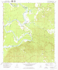
1972 Map of Woods Bluff
USGS Topo · Published 1980About this map
The Tombigbee River winds through this 1970s landscape, serving as the border between Marengo, Choctaw, and Clarke Counties. The river's historical importance as a transit artery is evidenced by numerous riverfront locations such as Barneys Lower Landing, Pickens Landing, and Wildcat Landing. Notable landmarks like Woods Bluff and Whites Bluff rise above the water, while the sharp arc of Cunningham Bend dominates the central topography.
Find a feature on this map
53 named features on this map. Tap any name to fly to it.
Don’t see what you’re looking for? This feature index may not catch every label — zoom into the map to look around manually.
Map Details
Editions of this 1972 Woods Bluff Map
2 editions found

Other maps of this area

1953 · Montgomery
USGS Topo · 1:250,000

1953 · Andalusia
USGS Topo · 1:250,000

1953 · Hattiesburg
USGS Topo · 1:250,000

1953 · Meridian
USGS Topo · 1:250,000

1956 · Montgomery
USGS Topo · 1:250,000

1957 · Meridian
USGS Topo · 1:250,000

1957 · Montgomery
USGS Topo · 1:250,000

1957 · Andalusia
USGS Topo · 1:250,000

1958 · Hattiesburg
USGS Topo · 1:250,000

1965 · Meridian
USGS Topo · 1:250,000