1960s Maps of Anchorage, Alaska
Explore 11 historic maps of Anchorage from the 1960s. These maps offer a rare glimpse into what life looked like during the 1960s — showing old roads, neighborhoods, homes, and landmarks that have changed or disappeared over time.
Whether you're researching your family's past, planning a metal detecting trip, or studying how Anchorage's landscape evolved across the 1960s, these high-resolution maps are a powerful tool for exploring the history of this region.
- Focus on a specific era: All maps on this page are from the 1960s, giving you a focused view of this time period.
- See what’s changed: Compare century-old streets, trails, and buildings to today's modern landscape using overlays and satellite layers.
- Research with precision: Use these maps for genealogy, historical research, land use analysis, or educational projects.
- View, download, or print: Maps are fully viewable online in high resolution, and can be downloaded or printed for your own records.
Start exploring Anchorage's history through authentic maps from the 1960s. This is your window into the past.
Anchorage, AK maps
(11)- 1960 Map of Anchorage A-6, 1961 Print
 1960 Anchorage A-61961 Print · USGSThe high alpine wilderness north of Girdwood was surveyed during the statehood era, capturing a landscape of active ice and early trails. Researchers can locate remote markers like The Cache and ruins, or trace historical routes through Crow Pass and across the Eagle Glacier.4 unique versions available
 - 1960 Map of Anchorage B-7, 1961 Print
 1960 Anchorage B-71961 Print · USGSThe growing communities north of Anchorage are captured here as they expanded during the mid-century. Genealogists and historians can trace the early infrastructure of Chugiak and Eagle River, or locate landmarks like Birchwood Auxiliary Airfield and Camp Gorsuch.4 unique versions available
 - 1960 Map of Anchorage B-6, 1961 Print
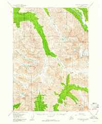
 1960 Anchorage B-61961 Print · USGSAlaska's Chugach mountain valleys come into focus in the early sixties as hydroelectric and transport infrastructure began to shape the region. Trace the historic route of the Alaska Railroad past the Eklutna Powerhouse and up to Eklutna Lake.5 unique versions available
 - 1960 Map of Anchorage A-7, 1961 Print
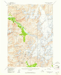
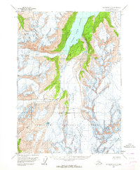
 1960 Anchorage A-71961 Print · USGSThe Chugach Mountains near Anchorage were a land of military frontiers and high-altitude wilderness during the early 1960s. Researchers can trace the perimeter of the Fort Richardson Military Reservation or locate the early Ski Bowl and remote cabins along the South Fork Eagle River.5 unique versions available
 - 1960 Map of Anchorage A-5, 1964 Print
 1960 Anchorage A-51964 Print · USGSAlaskan glacial landscapes and wild water systems are frozen in time during the late fifties and early sixties. Trace the vast reaches of the Colony Glacier and Upper Lake George within the protected bounds of the Chugach National Forest.4 unique versions available
 - 1960 Map of Anchorage A-4, 1964 Print
 1960 Anchorage A-41964 Print · USGSCoastal Alaska in the early sixties reveals a landscape of massive ice flows and deep saltwater inlets within the Chugach National Forest. Researchers can trace the mid-century extent of the Colony Glacier, Serpentine Glacier, and Surprise Glacier.3 unique versions available
 - 1960 Map of Anchorage B-5, 1964 Print
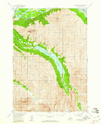
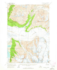
 1960 Anchorage B-51964 Print · USGSThe Chugach Mountains and Knik River valley appear in high detail during the early sixties, showing a landscape of advancing ice and rising lakes. Researchers can trace glacial extents and hydrology through Mt Palmer, Knik Glacier, and Inner Lake George.3 unique versions available
 - 1960 Map of Anchorage B-4, 1965 Print
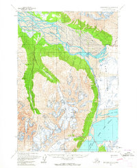
 1960 Anchorage B-41965 Print · USGSThe Knik River valley in the early 1960s was a remote expanse of active ice fields and mountain drainage. Researchers can trace the massive footprints of the Knik Glacier and Gannett Glacier or locate the isolated Landing Strip in Grasshopper Valley.3 unique versions available
 - 1962 Map of Anchorage, 1966 Print
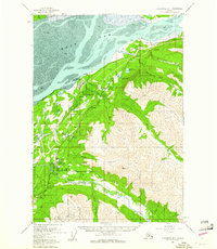
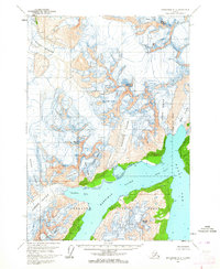
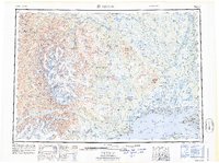
 1962 Anchorage1966 Print · USGSThe Anchorage bowl and Matanuska Valley appear in this mid-century survey during a period of significant military and industrial expansion. Researchers can trace the Alaska Railroad through Sutton and Jonesville or locate historic stops like Meekins Roadhouse and the Watertower Inn.6 unique versions available
 - 1965 Map of Tyonek
 1965 Tyonek1965 Print · USGSUpper Cook Inlet in the mid-sixties reveals a landscape defined by massive glaciers and the early footprints of coastal settlements. Trace the rail-and-river network from The Alaska Railroad to isolated outposts like Old Tyonek, Ladd, and the Moquawkie (Tyonek) Indian Reservation.
 - 1965 Map of Anchorage B-8
 1965 Anchorage B-81965 Print · USGSThe northern reaches of Cook Inlet are shown in the mid-twentieth century as military installations and rail lines expanded across the glacial moraine. Modern researchers can trace the historic Iditarod Trail, the settlement of Knik, and the early infrastructure of Elmendorf Air Force Base.
End of results
Showing maps 1-11 of 11
Top cities of Anchorage
Frequently asked questions
- What are the different types of historical maps available for Anchorage?
- What is the oldest map of Anchorage?
- Where can I purchase historical maps of Anchorage for my home or office?
- Where can I download high-res historical maps of Anchorage?
- Are there historical topographic maps available for Anchorage?
- Is there historical aerial imagery available for Anchorage?
- Where are historical maps of Anchorage sourced from?