1990s Maps of Anchorage, Alaska
Explore 19 historic maps of Anchorage from the 1990s. These maps offer a rare glimpse into what life looked like during the 1990s — showing old roads, neighborhoods, homes, and landmarks that have changed or disappeared over time.
Whether you're researching your family's past, planning a metal detecting trip, or studying how Anchorage's landscape evolved across the 1990s, these high-resolution maps are a powerful tool for exploring the history of this region.
- Focus on a specific era: All maps on this page are from the 1990s, giving you a focused view of this time period.
- See what’s changed: Compare century-old streets, trails, and buildings to today's modern landscape using overlays and satellite layers.
- Research with precision: Use these maps for genealogy, historical research, land use analysis, or educational projects.
- View, download, or print: Maps are fully viewable online in high resolution, and can be downloaded or printed for your own records.
Start exploring Anchorage's history through authentic maps from the 1990s. This is your window into the past.
Anchorage, AK maps
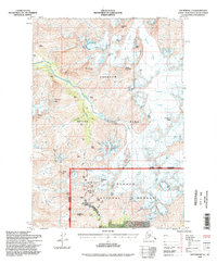
(19)- 1993 Map of Anchorage A-7 NE
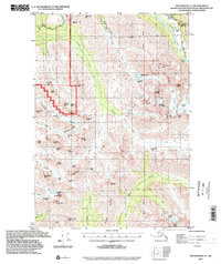
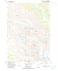 1993 Anchorage A-7 NE1993 Print · USGSChugach State Park in the early nineties preserved a vast alpine wilderness of glaciers and peaks just beyond the Anchorage municipal limits. Researchers can trace the path of the Iditarod National Historic Trail and locate remote sites like Symphony Lake and Echo Bend.
 - 1993 Map of Anchorage A-7 NW
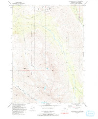 1993 Anchorage A-7 NW1993 Print · USGSThe eastern Alaskan wilderness meets military development in the early nineties, showing where the mountains rise above the Chugach basin. Researchers can trace the layout of the Alpenglow Ski Area and remote features like Tanaina Lake and Wolverine Peak.
 - 1993 Map of Seward D-8 NE
 1993 Seward D-8 NE1993 Print · USGSThe community of Hope and the surrounding Kenai Peninsula shores are shown in the early nineties, revealing a landscape of conservation and resource extraction. Researchers can locate the National Historic District and trace mining activity along Resurrection Creek including tailings and several prospects.
 - 1993 Map of Anchorage A-8 SW
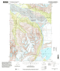
 1993 Anchorage A-8 SW1993 Print · USGSSouth Anchorage in the early nineties reveals a landscape of growing residential neighborhoods meeting the tidal mudflats of the Turnagain Arm. Trace local landmarks like the Evergreen Memorial Cem, Potter Marsh, and the Klatt settlement.
 - 1994 Map of Seward D-6, 1998 Print
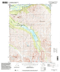
 1994 Seward D-61998 Print · USGSIn the 1990s, the Kenai Peninsula and Anchorage borderlands were defined by the growing Alyeska resort and the glacial waters of Turnagain Arm. Trace the legacy of early infrastructure at Lower Engineers Camp or locate recreation sites like Moose Flats and Williwaw.
 - 1994 Map of Seward D-8, 1998 Print
 1994 Seward D-81998 Print · USGSThe Kenai Peninsula near the turn of the millennium remains a landscape of mining heritage and vast wilderness areas. Researchers can trace the proximity of Hope to early-century sites like the Robinson-Bowman Mine and explore the path of the Winter Trail.
 - 1994 Map of Anchorage A-6, 1998 Print
 1994 Anchorage A-61998 Print · USGSAnchorage's mountain interior and historic mining claims are documented here during the 1990s as the wilderness boundaries were being refined. Trace the legacy of gold prospecting at the Crow Creek Mine or follow the Crow Pass Trail past Crystal Lake.
 - 1994 Map of Seward D-7, 1998 Print
 1994 Seward D-71998 Print · USGSThe Kenai Peninsula coastline meets the Chugach Mountains in the mid-1990s as the region's mining and maritime history remains etched into the land. Genealogists and historians can locate legacy sites like Sunrise Cemetery, Swetmann Camp, and the Connolly Mine.
 - 1994 Map of Anchorage B-4, 2001 Print
 1994 Anchorage B-42001 Print · USGSThe glacial wilderness east of Anchorage comes into focus in the mid-1990s at the intersection of two boroughs. Researchers can trace the massive Knik Glacier, the waters of Inner Lake George, and a remote Landing Strip.
 - 1994 Map of Anchorage B-6, 2002 Print
 1994 Anchorage B-62002 Print · USGSThe northern Chugach wilderness meets modern infrastructure in this mid-century survey of the Chugach and Matanuska-Susitna boundary. Trace the vital water and power systems of Eklutna Lake, including the Eklutna Dam, Eklutna Powerhouse, and the Bold Airport.
 - 1994 Map of Anchorage B-5, 2002 Print
 1994 Anchorage B-52002 Print · USGSThe glacial landscape east of Anchorage is captured in the mid-nineties, showing a wild terrain dominated by ice and rock. Researchers can trace the massive Knik Glacier and find named landmarks like Bashful Peak, The Gorge, and Colony Point.
 - 1994 Map of Anchorage A-7, 2002 Print
 1994 Anchorage A-72002 Print · USGSThe Chugach Mountains east of Anchorage appear here in the mid-1990s as a landscape of military boundaries and state park wilderness. You can trace the Iditarod National Historic Trail (Pack) along the Eagle River or locate backcountry landmarks like Symphony Lake and Bird Glacier.
 - 1994 Map of Anchorage A-8, 2002 Print
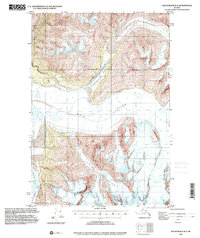
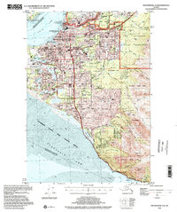 1994 Anchorage A-82002 Print · USGSAnchorage during the mid-nineties shows a city defined by its military bases, university campuses, and bustling aviation hubs. Researchers can trace the development of suburban neighborhoods and major landmarks like the Diamond Center Shopping Mall, Wilson Village, and the Fort Richardson Cem.
 - 1994 Map of Anchorage B-8, 2002 Print
 1994 Anchorage B-82002 Print · USGSThe Matanuska-Susitna region and the northern reaches of Anchorage meet here in the 1990s, where the historic Iditarod path intersects with modern military airfields. Researchers can trace the National Historic Trail (Iditarod) near Knik or locate the Ursa Major Sch within Elmendorf Air Force Base.
 - 1994 Map of Anchorage B-7, 2002 Print
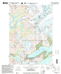
 1994 Anchorage B-72002 Print · USGSThe Eagle River valley and Chugach foothills are captured in the mid-nineties as the Glenn Highway corridor expanded. Researchers can trace the infrastructure of the era, from the Birchwood Airport and Alaska Railroad to the historic Eklutna Cem.
 - 1995 Map of Seward D-8, 1999 Print
 1995 Seward D-81999 Print · USGSThe Kenai Peninsula's mining history and coastal wilderness are documented in the mid-nineties, showing the interface of national forest and wildlife refuge lands. You can trace the remnants of the gold era through Historic Mining District Tailings and the Robinson-Bowman Mine south of Hope.
 - 1995 Map of Seward D-5, 1999 Print
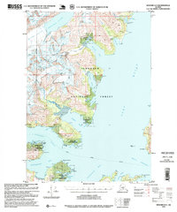
 1995 Seward D-51999 Print · USGSWhittier and the surrounding Chugach peaks are captured here in the mid-nineties, showing the strategic port and its rail connections. Researchers can trace the layout of the City of Whittier, the old Portage Mine, and the route of the Byron Glacier Trail.
 - 1995 Map of Seward D-4, 1999 Print
 1995 Seward D-41999 Print · USGSCoastal Alaska in the mid-nineties shows a landscape of industrial extraction and marine conservation. Researchers can trace the location of the Granite Mine, find the Logging Camp at Passage Canal, and locate the Harrison Lagoon Cabin.
 - 1997 Map of Seward C-6, 2000 Print
 1997 Seward C-62000 Print · USGSThe Kenai Peninsula's interior was a land of ice and high summits in the late nineties, defined by the moving ice of Spencer Glacier. Researchers can trace the isolated rail-and-trail route connecting Grandview, Hunter, and the Tunnel site.
End of results
Showing maps 1-19 of 19
Top cities of Anchorage
Frequently asked questions
- What are the different types of historical maps available for Anchorage?
- What is the oldest map of Anchorage?
- Where can I purchase historical maps of Anchorage for my home or office?
- Where can I download high-res historical maps of Anchorage?
- Are there historical topographic maps available for Anchorage?
- Is there historical aerial imagery available for Anchorage?
- Where are historical maps of Anchorage sourced from?