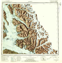
1950s Maps of Juneau, Alaska
Explore 19 historic maps of Juneau from the 1950s. These maps offer a rare glimpse into what life looked like during the 1950s — showing old roads, neighborhoods, homes, and landmarks that have changed or disappeared over time.
Whether you're researching your family's past, planning a metal detecting trip, or studying how Juneau's landscape evolved across the 1950s, these high-resolution maps are a powerful tool for exploring the history of this region.
- Focus on a specific era: All maps on this page are from the 1950s, giving you a focused view of this time period.
- See what’s changed: Compare century-old streets, trails, and buildings to today's modern landscape using overlays and satellite layers.
- Research with precision: Use these maps for genealogy, historical research, land use analysis, or educational projects.
- View, download, or print: Maps are fully viewable online in high resolution, and can be downloaded or printed for your own records.
Start exploring Juneau's history through authentic maps from the 1950s. This is your window into the past.
Juneau, AK maps
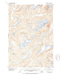
(19)- 1950 Map of Juneau A-3, 1964 Print
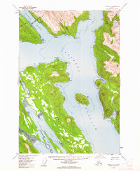
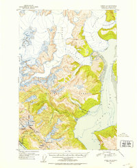
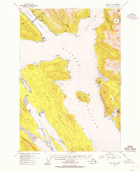
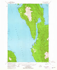 1950 Juneau A-31964 Print · USGSThe maritime wilderness of the Mansfield Peninsula is captured here in the 1950s, showing a landscape defined by salmon processing and mining. Researchers can trace the industrial footprint of the Hawk Inlet Cannery, the aviation history at the Seaplane Base, and the upland Tramway near Robert Barron Peak.3 unique versions available
 - 1951 Map of Juneau
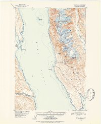
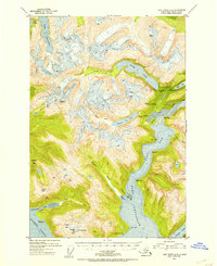
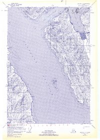
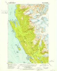
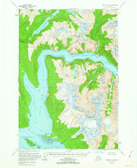
 1951 Juneau1951 Print · USGSJuneau and the industrial waterfront of the Gastineau Channel are shown here at the start of the 1950s. Researchers can trace the mid-century footprint of Juneau, the mining history of Treadwell, and remote maritime outposts like Hoonah and Gustavus.4 unique versions available
 - 1951 Map of Juneau D-4, 1952 Print
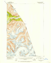
 1951 Juneau D-41952 Print · USGSSoutheast Alaska’s maritime and mining frontiers meet along Lynn Canal in the early fifties. Genealogists and industrial historians can trace the dormant gold works at Kensington Mine and the isolated Eldred Rock Lighthouse.2 unique versions available
 - 1951 Map of Taku River A-4, 1954 Print
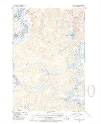
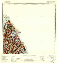
 1951 Taku River A-41954 Print · USGSThe international boundary between Alaska and British Columbia is charted here in the early 1950s. Trace the high-altitude frontier through Boundary Peak 83 and follow the path of the Whiting River through the Coast Mountains.3 unique versions available
 - 1951 Map of Taku River B-6, 1954 Print
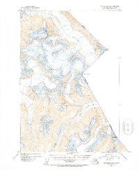
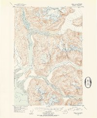
 1951 Taku River B-61954 Print · USGSSoutheast Alaska's coastal wilderness comes into focus in the mid-fifties, showing the intersection of the Taku River and the international boundary. Researchers can trace early land claims at HES NO 108 and locate remote structures like Taku Lodge and the Customhouse.4 unique versions available
 - 1951 Map of Taku River A-5, 1954 Print
 1951 Taku River A-51954 Print · USGSThe wilderness south of Juneau is captured in the early fifties, documenting the glacial river systems within Tongass National Forest. Researchers can trace the drainages of the Speel River and Whiting River or locate remote landmarks like Snow Tower.4 unique versions available
 - 1951 Map of Taku River A-6, 1954 Print
 1951 Taku River A-61954 Print · USGSSoutheast Alaska's coastal wilderness near Port Snettisham is documented here during the early fifties, showing a landscape defined by glacial inlets and mining prospects. Researchers can trace early industrial activity at the Whigg Placer Mine and locate isolated landmarks like the Gaging Sta and a remote Cabin.4 unique versions available
 - 1951 Map of Taku River B-5, 1954 Print
 1951 Taku River B-51954 Print · USGSThe Alaska-Canada borderlands near Juneau are captured here in the early fifties, showing a landscape defined by massive ice and high peaks. Researchers can trace the international boundary line across summits like Mount Ogden and follow the path of the Wright Glacier.4 unique versions available
 - 1951 Map of Juneau A-2, 1956 Print
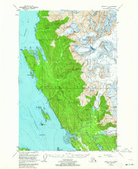
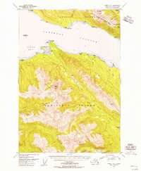 1951 Juneau A-21956 Print · USGSDouglas and Admiralty Islands are shown in the early fifties, capturing the maritime and mining character of the Alexander Archipelago. Researchers can trace the path of the Treadwell Ditch or locate remote camps near Admiralty Cove and Young Lake.3 unique versions available
 - 1951 Map of Juneau A-1, 1962 Print
 1951 Juneau A-11962 Print · USGSThe coastal waters south of Juneau during the early fifties reveal a landscape of remote harbors and cultural landmarks. You can locate the Kuteha Indian Burial Grounds, the settlement at Dupont, and the maritime facilities at Taku Harbor.2 unique versions available
 - 1951 Map of Sumdum D-6, 1963 Print
 1951 Sumdum D-61963 Print · USGSStephens Passage and the wild coast of Admiralty Island appear here as they were surveyed in the early postwar era. Maritime researchers and historians can trace navigational landmarks like the Midway Islands, the mouth of the Whiting River, and a coastal Mine.3 unique versions available
 - 1951 Map of Juneau C-3, 1964 Print
 1951 Juneau C-31964 Print · USGSCoastal Juneau in the early fifties shows a rugged landscape where the industrial heritage of the Bessie Mine meets the advancing ice of Eagle Glacier. You can trace old mining trails and shoreline landmarks like Sentinel I and the remote Cabins along the Glacier Highway.3 unique versions available
 - 1952 Map of Sumdum, 1953 Print
 1952 Sumdum1953 Print · USGSSoutheast Alaska in the early fifties was a land of tidewater glaciers and isolated mining outposts. Researchers can trace the layout of remote coastal settlements like Windham and Sumdum or locate the historic Chuck Mining Camp near Endicott Arm.6 unique versions available
 - 1952 Map of Juneau B-1, 1953 Print
 1952 Juneau B-11953 Print · USGSSoutheast Alaska in the early fifties shows a rugged landscape defined by massive ice fields and industrial outposts. Genealogists and historians can trace the mining footprint at Thane or the remote sites of Portal Camp and Camp No 6 near the Gastineau Channel.3 unique versions available
 - 1952 Map of Juneau C-3, 1953 Print
 1952 Juneau C-31953 Print · USGSThe coastal wilderness north of Juneau is captured here in the early fifties, showing a landscape defined by industrial mining and maritime navigation. You can trace the proximity of the Bessie Mine to the coast and locate the Lighthouse on Sentinel I and the end of the Glacier Highway.2 unique versions available
 - 1953 Map of Taku River
 1953 Taku River1953 Print · USGSThe Alaska and British Columbia borderlands come into focus in the early 1950s, showing a landscape of massive ice fields and deep coastal inlets. Researchers can trace the international boundary line across peaks like Mt Ogden and locate remote features such as the Cabin near Twin Glacier Lake.4 unique versions available
 - 1953 Map of Juneau D-3, 1954 Print
 1953 Juneau D-31954 Print · USGSSoutheast Alaska in the early fifties shows a wild landscape of river deltas and mountain peaks within the Tongass National Forest. Researchers can locate a lone Cabin and trace the braided channels of the Lace River and Antler River as they enter Berners Bay.2 unique versions available
 - 1954 Map of Juneau A-1, 1956 Print
 1954 Juneau A-11956 Print · USGSCoastal life in the mid-1950s centered on the waterways around STEPHENS PASSAGE and the TONGASS NATIONAL FOREST BOUNDARY. Genealogists and historians can locate the Kuteha Indian Burial Grounds, the settlement at Taku Harbor, and remote landmarks like Butler Peak.
 - 1955 Map of Sumdum D-5, 1963 Print
 1955 Sumdum D-51963 Print · USGSThe convergence of Tracy Arm and Endicott Arm is captured here in the mid-1950s, revealing a landscape of shifting ice and isolated outposts. Researchers can locate the site of Indian Village and a remote Cabin near Mt Sumdum.3 unique versions available
End of results
Showing maps 1-19 of 19
Top cities of Juneau
Frequently asked questions
- What are the different types of historical maps available for Juneau?
- What is the oldest map of Juneau?
- Where can I purchase historical maps of Juneau for my home or office?
- Where can I download high-res historical maps of Juneau?
- Are there historical topographic maps available for Juneau?
- Is there historical aerial imagery available for Juneau?
- Where are historical maps of Juneau sourced from?