Old Maps of Juneau, Alaska for Metal Detecting
Plan your next treasure hunt with 249 historic maps of Juneau. Find old homesites, ghost towns, trails, and gathering spots that may be lost to time — perfect for identifying promising metal detecting locations.
- Locate forgotten sites: Uncover places like long-lost settlements, abandoned rail lines, or gathering spots.
- Plan better hunts: Use map overlays combined with LiDAR or satellite views to narrow in on historically rich areas.
- Made for detectorists: Thousands of hobbyists use these maps to discover relics, coins, and hidden history.
Use these historic maps to boost your research and find new opportunities beneath the surface of Juneau.
Juneau, AK maps
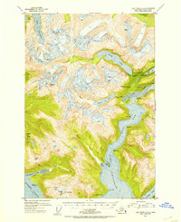
(249)- 1947 Map of Juneau B-3, 1955 Print
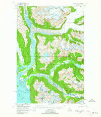
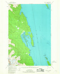
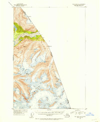
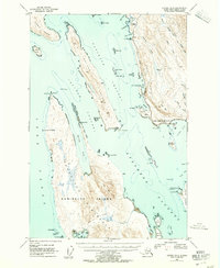 1947 Juneau B-31955 Print · USGSThe coastal waters north of Juneau come alive in the late 1940s, showing a maritime landscape of channels and remote landings. Researchers can trace early infrastructure like the lighthouse at Point Retreat, the small settlement at Dotsons Landing, and the original Glacier Highway route.2 unique versions available
 - 1947 Map of Juneau B-2, 1955 Print
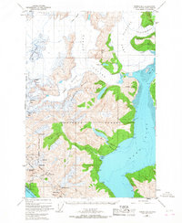
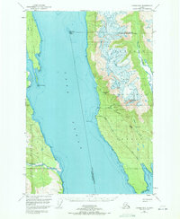
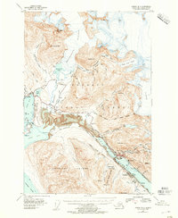 1947 Juneau B-21955 Print · USGSThe industrial waterfront of Juneau and Douglas comes to life in the years following the war. Genealogists and historians can trace mining sites like the Alaska-Juneau Mill, the development of the Juneau Airport, and the early layout of Treadwell.2 unique versions available
 - 1948 Map of Juneau B-4, 1956 Print
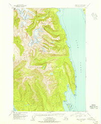 1948 Juneau B-41956 Print · USGSSoutheast Alaska’s coastal wilderness is captured in the late 1940s, showing the meeting of mountain and sea before modern infrastructure. Trace the shoreline of Lynn Canal to find isolated landmarks like Pt Howard, Lincoln Island, and the Lynn Sisters.2 unique versions available
 - 1948 Map of Juneau A-3, 1956 Print
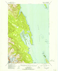
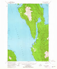
 1948 Juneau A-31956 Print · USGSAdmiralty Island in the late 1940s was a hub of remote industry and rugged coastal activity. Researchers can trace the maritime infrastructure of the Hawk Inlet Cannery or locate isolated resource sites like the Admiralty Mine and its hillside Tramway.
 - 1948 Map of Juneau C-4, 1956 Print
 1948 Juneau C-41956 Print · USGSThe waters of the northern Alexander Archipelago are captured here in the late 1940s, highlighting the maritime navigation and coastal terrain of Southeast Alaska. Maritime historians and researchers can trace landmarks like Vanderbilt Reef Light, the small Cabin sites, and the islands of Lincoln Island and the Lynn Sisters.
 - 1948 Map of Sumdum D-6, 1957 Print
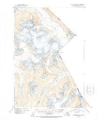
 1948 Sumdum D-61957 Print · USGSStephens Passage and Port Snettisham are captured here in the late 1940s, a period when mining still shaped the remote Alaskan coast. Researchers can trace historic operations at the Friday Mine and Crystal Mines or locate the small settlement at Snettisham.
 - 1948 Map of Sumdum D-5, 1957 Print
 1948 Sumdum D-51957 Print · USGSGlacial fjords and maritime history intersect in this 1940s survey of the Alaska coast before modern development changed the shoreline. Researchers can locate the Indian Village (Aband) and a remote Cabin on Harbor Island.
 - 1948 Map of Juneau D-3, 1964 Print
 1948 Juneau D-31964 Print · USGSCoastal Alaska in the late 1940s is defined here by the convergence of glacial rivers into Berners Bay within the Tongass National Forest. Researchers can trace the wild paths of the Lace River and Antler River past a lonely Cabin on the shoreline.3 unique versions available
 - 1948 Map of Juneau B-1, 1967 Print
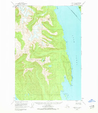
 1948 Juneau B-11967 Print · USGSThe wilderness surrounding Juneau in the late 1940s reveals a specialized landscape of industrial camps and massive ice fields. Genealogists and historians can trace mining activity and infrastructure near Thane, identifying local landmarks like the Power Plant and Portal Camp.2 unique versions available
 - 1949 Map of Juneau B-3
 1949 Juneau B-31949 Print · USGSThe Juneau coastline in the late 1940s is shown here as a landscape of maritime channels and early highway development. Researchers can trace historic access points like Dotsons Landing, the St Terese mission, and remote inlets such as Funter Bay.
 - 1949 Map of Juneau B-2
 1949 Juneau B-21949 Print · USGSJuneau and Douglas Island appear at a pivotal post-war moment when mining infrastructure and new aviation developments sat side-by-side. Trace the legacy of the gold era through the Alaska Juneau Mill, the Ebner Adit, and the industrial footprint at Treadwell.
 - 1949 Map of Juneau D-4, 1965 Print
 1949 Juneau D-41965 Print · USGSThe mining camps and coastal outposts of the Lynn Canal corridor come into focus in this mid-century survey. Genealogists and industrial historians can trace the foundations of the Kensington Mine, the Eldred Rock Lighthouse, and the remote settlement at Comet.3 unique versions available
 - 1949 Map of Juneau C-4, 1967 Print
 1949 Juneau C-41967 Print · USGSThe Lynn Canal and the rugged coastline of the Chilkat Range are captured here in the late 1940s. Maritime researchers can trace essential navigational landmarks like Vanderbilt Reef Light and the remote shores of St James Bay.2 unique versions available
 - 1949 Map of Juneau D-3, 1971 Print
 1949 Juneau D-31971 Print · USGSThe eastern coast of Lynn Canal in the late 1940s reveals a landscape defined by industrial mining and maritime safety. Researchers can trace historic operations at the Kensington Mine, locate the Eldred Rock lighthouse, or find the small settlement at Sherman.
 - 1949 Map of Juneau B-4, 1974 Print
 1949 Juneau B-41974 Print · USGSCoastal wilderness in the Chilkat Range appears here as it was surveyed shortly after the war, showing a landscape defined by water and rock rather than roads. Researchers can trace the maritime geography of Lynn Canal and landmarks like Mount Golub and Lincoln Island.2 unique versions available
 - 1950 Map of Juneau A-3, 1964 Print
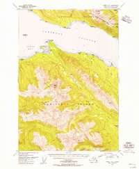
 1950 Juneau A-31964 Print · USGSThe maritime wilderness of the Mansfield Peninsula is captured here in the 1950s, showing a landscape defined by salmon processing and mining. Researchers can trace the industrial footprint of the Hawk Inlet Cannery, the aviation history at the Seaplane Base, and the upland Tramway near Robert Barron Peak.3 unique versions available
 - 1951 Map of Juneau
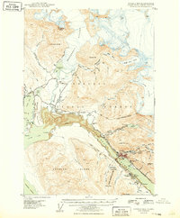
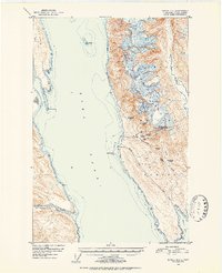
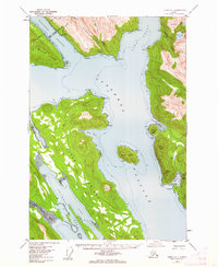
 1951 Juneau1951 Print · USGSJuneau and the industrial waterfront of the Gastineau Channel are shown here at the start of the 1950s. Researchers can trace the mid-century footprint of Juneau, the mining history of Treadwell, and remote maritime outposts like Hoonah and Gustavus.4 unique versions available
 - 1951 Map of Juneau D-4, 1952 Print
 1951 Juneau D-41952 Print · USGSSoutheast Alaska’s maritime and mining frontiers meet along Lynn Canal in the early fifties. Genealogists and industrial historians can trace the dormant gold works at Kensington Mine and the isolated Eldred Rock Lighthouse.2 unique versions available
 - 1951 Map of Taku River A-4, 1954 Print
 1951 Taku River A-41954 Print · USGSThe international boundary between Alaska and British Columbia is charted here in the early 1950s. Trace the high-altitude frontier through Boundary Peak 83 and follow the path of the Whiting River through the Coast Mountains.3 unique versions available
 - 1951 Map of Taku River B-6, 1954 Print
 1951 Taku River B-61954 Print · USGSSoutheast Alaska's coastal wilderness comes into focus in the mid-fifties, showing the intersection of the Taku River and the international boundary. Researchers can trace early land claims at HES NO 108 and locate remote structures like Taku Lodge and the Customhouse.4 unique versions available
 - 1951 Map of Taku River A-5, 1954 Print
 1951 Taku River A-51954 Print · USGSThe wilderness south of Juneau is captured in the early fifties, documenting the glacial river systems within Tongass National Forest. Researchers can trace the drainages of the Speel River and Whiting River or locate remote landmarks like Snow Tower.4 unique versions available
 - 1951 Map of Taku River A-6, 1954 Print
 1951 Taku River A-61954 Print · USGSSoutheast Alaska's coastal wilderness near Port Snettisham is documented here during the early fifties, showing a landscape defined by glacial inlets and mining prospects. Researchers can trace early industrial activity at the Whigg Placer Mine and locate isolated landmarks like the Gaging Sta and a remote Cabin.4 unique versions available
 - 1951 Map of Taku River B-5, 1954 Print
 1951 Taku River B-51954 Print · USGSThe Alaska-Canada borderlands near Juneau are captured here in the early fifties, showing a landscape defined by massive ice and high peaks. Researchers can trace the international boundary line across summits like Mount Ogden and follow the path of the Wright Glacier.4 unique versions available
 - 1951 Map of Juneau A-2, 1956 Print
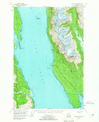
 1951 Juneau A-21956 Print · USGSDouglas and Admiralty Islands are shown in the early fifties, capturing the maritime and mining character of the Alexander Archipelago. Researchers can trace the path of the Treadwell Ditch or locate remote camps near Admiralty Cove and Young Lake.3 unique versions available
 - 1951 Map of Juneau A-1, 1962 Print
 1951 Juneau A-11962 Print · USGSThe coastal waters south of Juneau during the early fifties reveal a landscape of remote harbors and cultural landmarks. You can locate the Kuteha Indian Burial Grounds, the settlement at Dupont, and the maritime facilities at Taku Harbor.2 unique versions available
Showing maps 1-25 of 249
Top cities of Juneau
Frequently asked questions
- What are the different types of historical maps available for Juneau?
- What is the oldest map of Juneau?
- Where can I purchase historical maps of Juneau for my home or office?
- Where can I download high-res historical maps of Juneau?
- Are there historical topographic maps available for Juneau?
- Is there historical aerial imagery available for Juneau?
- Where are historical maps of Juneau sourced from?