1990s Maps of Juneau, Alaska
Explore 13 historic maps of Juneau from the 1990s. These maps offer a rare glimpse into what life looked like during the 1990s — showing old roads, neighborhoods, homes, and landmarks that have changed or disappeared over time.
Whether you're researching your family's past, planning a metal detecting trip, or studying how Juneau's landscape evolved across the 1990s, these high-resolution maps are a powerful tool for exploring the history of this region.
- Focus on a specific era: All maps on this page are from the 1990s, giving you a focused view of this time period.
- See what’s changed: Compare century-old streets, trails, and buildings to today's modern landscape using overlays and satellite layers.
- Research with precision: Use these maps for genealogy, historical research, land use analysis, or educational projects.
- View, download, or print: Maps are fully viewable online in high resolution, and can be downloaded or printed for your own records.
Start exploring Juneau's history through authentic maps from the 1990s. This is your window into the past.
Juneau, AK maps
(13)- 1994 Map of Sumdum D-5, 1998 Print
 1994 Sumdum D-51998 Print · USGSThe glacial fjords and maritime wilderness of southeast Alaska are captured here in the 1990s. Researchers can locate the Indian Village (Aban'd) and trace the coastal waters of Tracy Arm and Holkham Bay.
 - 1994 Map of Taku River B-6, 1998 Print
 1994 Taku River B-61998 Print · USGSThe Juneau wilderness of the 1990s is captured here, showcasing a landscape of glaciers and isolated outposts. Researchers can trace remote cabin locations and land claims like West Turner Lake Cabin (FS) and USS No 1200 near the Taku River.
 - 1995 Map of Taku River C-6, 1999 Print
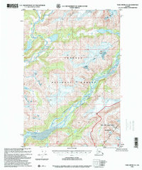
 1995 Taku River C-61999 Print · USGSThe Taku River drainage along the Alaska-Canada border reveals a landscape of shifting ice and high mountain peaks during the mid-nineties. Researchers can locate remote riverfront cabins and trace the paths of the West Twin Glacier and East Twin Glacier.
 - 1996 Map of Juneau B-4, 2000 Print
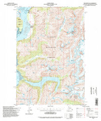
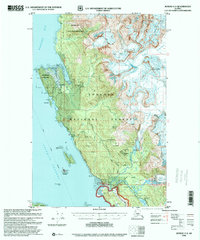
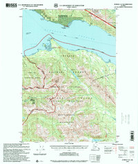
 1996 Juneau B-42000 Print · USGSCoastal wilderness and the heights of the Chilkat Range are documented in the late nineties as they border the City and Borough of Juneau. Trace the intersection of Glacier Bay National Park and the Tongass National Forest along Lynn Canal.
 - 1996 Map of Juneau C-4, 2000 Print
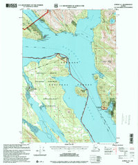
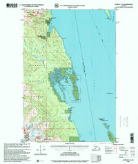 1996 Juneau C-42000 Print · USGSThe Lynn Canal maritime corridor was a critical transit point in the late nineties, linking the Juneau and Haines boroughs by water. Researchers can trace remote coastal outposts like the Radio Repeater and navigate the protected reaches of St James Bay State Marine Park and the Lighthouse Reserve.
 - 1996 Map of Taku River A-5, 2000 Print
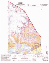
 1996 Taku River A-52000 Print · USGSThe coastal drainages of the Juneau area are documented in the late twentieth century, showing the intersection of glacial rivers and protected wilderness. Trace the paths of the Whiting River and Speel River past landmarks like Snow Tower and Prospect.
 - 1996 Map of Juneau C-3, 2000 Print
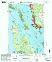
 1996 Juneau C-32000 Print · USGSThe coastal wilderness north of Juneau is mapped here in the late twentieth century, showing the intersection of industrial mining history and glacial geography. Researchers can find old mining sites like Amalga (Site) and the Eagle River Mine alongside the Sentinel Island Lighthouse Reserve.
 - 1996 Map of Juneau B-3, 2000 Print
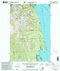
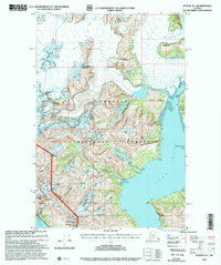
 1996 Juneau B-32000 Print · USGSThe coastal reaches of Juneau and Admiralty Island are captured here in the late twentieth century. Researchers can trace historic industrial sites like the Cannery Ruins at Funter or locate the John Muir Cabin (FS) and Auke Village.
 - 1996 Map of Juneau A-1, 2000 Print
 1996 Juneau A-12000 Print · USGSThe maritime and mining frontier south of the city comes into focus in the mid-nineties. Trace industrial history at the Alaska Treasure Mine or the Mill Ruins, and locate remote landmarks like Taku Harbor and the Tramway.
 - 1996 Map of Juneau A-2, 2000 Print
 1996 Juneau A-22000 Print · USGSIn the wilderness surrounding Juneau during the late twentieth century, this survey tracks the intersection of heavy industry and protected forest. Researchers can locate remote Forest Service outposts like Admiralty Cove Cabin and the massive Greens Creek Mine.
 - 1997 Map of Juneau A-3, 2000 Print
 1997 Juneau A-32000 Print · USGSThe maritime crossroads of Southeast Alaska are captured here in the late twentieth century, showing the rugged intersection of industrial mining and wilderness preservation. Trace the shorelines of Funter Bay and Hawk Inlet to find the Admiralty Mine and isolated Cabins.
 - 1997 Map of Juneau B-1, 2000 Print
 1997 Juneau B-12000 Print · USGSThe glacial landscapes and industrial outposts south of Juneau are captured here in the late 1990s as ice and sea meet. Trace the legacy of early industry through the Mines near Thane and remote camps like Portal Camp and Camp No 2.
 - 1997 Map of Juneau D-2, 2000 Print
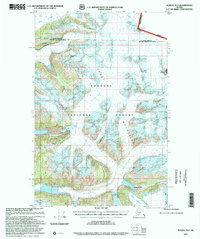 1997 Juneau D-22000 Print · USGSThe international boundary between Alaska and British Columbia near Juneau is shown here in the late 1990s as it cuts through the high peaks of the Coast Mountains. Trace the massive ice fields of Field Glacier and the steep terrain of The Wall.
End of results
Showing maps 1-13 of 13
Top cities of Juneau
Frequently asked questions
- What are the different types of historical maps available for Juneau?
- What is the oldest map of Juneau?
- Where can I purchase historical maps of Juneau for my home or office?
- Where can I download high-res historical maps of Juneau?
- Are there historical topographic maps available for Juneau?
- Is there historical aerial imagery available for Juneau?
- Where are historical maps of Juneau sourced from?