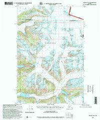
1997 Map of Juneau D-2
USGS Topo · Published 2000About this map
The Coast Mountains define this section of the Tongass National Forest, where a massive network of ice fields and glaciers dominates the high-altitude topography. Surveyed in the late 1940s and updated through 1997, the map illustrates the expansive reach of the Field Glacier and Bucher Glacier, which feed into the rugged drainages of the Gilkey R. The international boundary between the Canada and United States is marked by high-altitude points such as Boundary Peak 99 and Mount Bressler, illustrating the remote border as it runs through some of the most isolated terrain in the Haines Borough and City and Borough of Juneau. Significant geological features like Avalanche Canyon and the precipitous heights of The Wall highlight a landscape shaped by active glacial movement and alpine erosion.
Find a feature on this map
16 named features on this map. Tap any name to fly to it.
Don’t see what you’re looking for? This feature index may not catch every label — zoom into the map to look around manually.
Map Details
Editions of this 1997 Juneau D-2 Map
This is the sole edition of this map. No revisions or reprints were ever made.
Other maps of this area

1948 · Juneau D-3
USGS Topo · 1:63,360

1949 · Atlin
USGS Topo · 1:250,000

1949 · Juneau D-3
USGS Topo · 1:63,360

1951 · Juneau
USGS Topo · 1:250,000

1951 · Atlin
USGS Topo · 1:250,000

1951 · Juneau C-3
USGS Topo · 1:63,360

1952 · Juneau C-3
USGS Topo · 1:63,360

1953 · Juneau D-3
USGS Topo · 1:63,360

1960 · Juneau D-1
USGS Topo · 1:63,360

1960 · Juneau C-2
USGS Topo · 1:63,360