1980s Maps of Juneau, Alaska
Explore 14 historic maps of Juneau from the 1980s. These maps offer a rare glimpse into what life looked like during the 1980s — showing old roads, neighborhoods, homes, and landmarks that have changed or disappeared over time.
Whether you're researching your family's past, planning a metal detecting trip, or studying how Juneau's landscape evolved across the 1980s, these high-resolution maps are a powerful tool for exploring the history of this region.
- Focus on a specific era: All maps on this page are from the 1980s, giving you a focused view of this time period.
- See what’s changed: Compare century-old streets, trails, and buildings to today's modern landscape using overlays and satellite layers.
- Research with precision: Use these maps for genealogy, historical research, land use analysis, or educational projects.
- View, download, or print: Maps are fully viewable online in high resolution, and can be downloaded or printed for your own records.
Start exploring Juneau's history through authentic maps from the 1980s. This is your window into the past.
Juneau, AK maps
(14)- 1986 Map of Juneau B-3 SE, 1987 Print
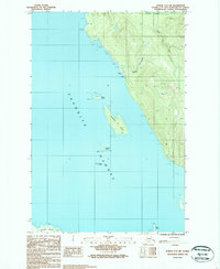
 1986 Juneau B-3 SE1987 Print · USGSThe maritime reaches of the Juneau area are documented in the mid-1980s, showcasing the intricate shorelines of Admiralty Island and Douglas Island. Researchers can locate isolated outposts like Auke Cabin and trace the tidal flats around Coghlan Island and Horse Island.
 - 1986 Map of Juneau A-2 NE, 1987 Print
 1986 Juneau A-2 NE1987 Print · USGSCoastal Juneau and its surrounding island wilderness are captured here in the mid-eighties. Researchers can trace the rugged topography from Mount Bradley down to maritime landmarks like Oliver Inlet and Ready Bullion Creek.
 - 1986 Map of Juneau C-3 SW, 1987 Print
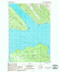
 1986 Juneau C-3 SW1987 Print · USGSThe coastal waters of the Favorite Channel near Juneau come alive in the mid-1980s, documenting a landscape of maritime navigation and mineral exploration. Researchers can trace historic industrial activity at the Mine Shaft and Prospect sites or locate the Lighthouse on Sentinel Island.
 - 1986 Map of Juneau B-1 SW, 1987 Print
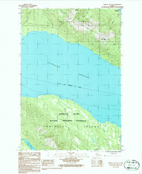
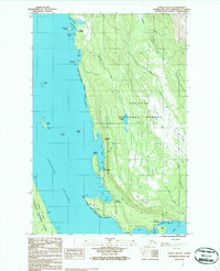
 1986 Juneau B-1 SW1987 Print · USGSThe Gastineau Channel and the rugged glaciers east of Juneau are captured here in the mid-eighties. Researchers can trace the industrial footprint at Thane, locate early mining Adits, and find the Fish Hatchery and Portal Camp.
 - 1986 Map of Juneau B-2 SW, 1987 Print
 1986 Juneau B-2 SW1987 Print · USGSSoutheast Alaska in the mid-eighties was a landscape of deep channels and towering peaks within the Tongass National Forest. You can trace the drainage of Cropley Lake or locate named summits like Mount Ben Stewart and Saddle Mountain.2 unique versions available
 - 1986 Map of Juneau A-2 NW, 1987 Print
 1986 Juneau A-2 NW1987 Print · USGSThe coastal wilderness of the Juneau area is captured in the mid-1980s, documenting the intricate shorelines of Douglas Island and Admiralty Island. Researchers can locate isolated landmarks like the Cabin at Admiralty Cove or trace the tidal reaches of Admiralty Creek.
 - 1986 Map of Juneau B-2 NW, 1987 Print
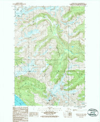
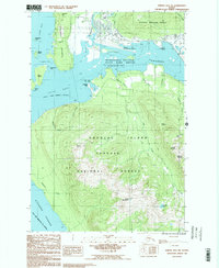
 1986 Juneau B-2 NW1987 Print · USGSGreater Juneau in the mid-eighties shows a landscape of glacial retreat and residential expansion near the Mendenhall Valley. Researchers can trace the development of Mendenhaven and the University of Alaska (Juneau) alongside landmarks like Dredge Lake and Auke Lake.2 unique versions available
 - 1986 Map of Juneau C-3 SE, 1987 Print
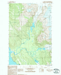 1986 Juneau C-3 SE1987 Print · USGSSoutheast Alaska in the mid-eighties was a landscape of massive glacial movement and drainage, documented here through the vast reach of the Tongass National Forest. Researchers can trace the braided paths of the Eagle River and Herbert River as they flow from the Eagle Glacier toward the coast.
 - 1986 Map of Juneau B-2 SE, 1987 Print
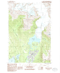
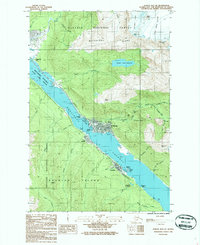 1986 Juneau B-2 SE1987 Print · USGSThe Alaskan capital and Douglas Island appear here in the mid-eighties, showing the intersection of state government and deep-rooted mining history. Researchers can locate the Treadwell (Site), the State Capitol, and the Treadwell Glory Hole.2 unique versions available
 - 1986 Map of Juneau A-1 NW, 1987 Print
 1986 Juneau A-1 NW1987 Print · USGSThe coastal waters near Juneau in the mid-1980s are captured here as the region's wilderness boundaries and maritime landmarks were firmly established. Researchers can trace the shoreline of Douglas Island and identify navigational points like Point Salisbury or the remote reaches of Oliver Inlet.
 - 1986 Map of Juneau B-3 SW, 1987 Print
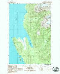
 1986 Juneau B-3 SW1987 Print · USGSAdmiralty Island’s Mansfield Peninsula is shown in high detail during the mid-eighties, highlighting the complex shoreline of the Alexander Archipelago. Researchers can trace the rugged coastal geography of Funter Bay, the heights of Green Mountain, and isolated maritime markers like False Point Retreat.
 - 1986 Map of Juneau C-3 NW, 1987 Print
 1986 Juneau C-3 NW1987 Print · USGSCoastal wilderness and glacial waterways are documented during the mid-eighties along the shores of Berners Bay. Researchers can trace the remote geography of Point Bridget or locate early industrial markers like the Landing Strip and Gravel Pit.
 - 1986 Map of Juneau B-3 NE, 1987 Print
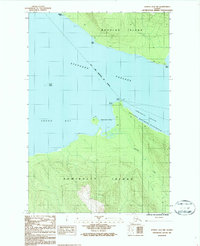
 1986 Juneau B-3 NE1987 Print · USGSCoastal Juneau in the mid-1980s reveals a landscape of sheltered harbors and forest boundaries at the edge of the Favorite Channel. Researchers can trace the development of Tee Harbor, locate the Shrine of St Terese, and identify early landings like Dotsons Landing.
 - 1986 Map of Juneau B-3 NW, 1987 Print
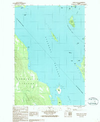
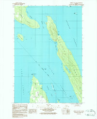 1986 Juneau B-3 NW1987 Print · USGSCoastal Juneau in the mid-eighties was a maritime wilderness defined by isolated outposts and intricate waterways. Trace the navigational markers at Point Retreat Lighthouse or locate remote Cabins on Shelter Island and Lincoln Island.
End of results
Showing maps 1-14 of 14
Top cities of Juneau
Frequently asked questions
- What are the different types of historical maps available for Juneau?
- What is the oldest map of Juneau?
- Where can I purchase historical maps of Juneau for my home or office?
- Where can I download high-res historical maps of Juneau?
- Are there historical topographic maps available for Juneau?
- Is there historical aerial imagery available for Juneau?
- Where are historical maps of Juneau sourced from?