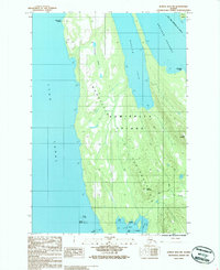
1986 Map of Juneau B-3 SW
USGS Topo · Published 1987About this map
Admiralty Island dominates this mid-1980s topographical study, specifically focusing on the northern stretches of the Mansfield Peninsula. This coastal region is defined by deep inlets and hazardous maritime passages, including the Saginaw Channel to the east and the expansive Lynn Canal to the west. The map records the intricate shoreline of Funter Bay at the southern edge, where Coot Cove and Crab Cove provide sheltered waters behind Ledge I and Star Rock.
Find a feature on this map
22 named features on this map. Tap any name to fly to it.
Don’t see what you’re looking for? This feature index may not catch every label — zoom into the map to look around manually.
Map Details
Editions of this 1986 Juneau B-3 SW Map
This is the sole edition of this map. No revisions or reprints were ever made.
Other maps of this area

1947 · Juneau B-3
USGS Topo · 1:63,360

1948 · Juneau B-4
USGS Topo · 1:63,360

1948 · Juneau A-3
USGS Topo · 1:63,360

1948 · Juneau A-4
USGS Topo · 1:63,360

1949 · Juneau B-3
USGS Topo · 1:62,500

1949 · Juneau B-4
USGS Topo · 1:63,360

1950 · Juneau A-3
USGS Topo · 1:63,360

1951 · Juneau
USGS Topo · 1:250,000

1962 · Juneau B-3
USGS Topo · 1:63,360

1962 · Juneau
USGS Topo · 1:250,000