1990s Maps of Petersburg Borough, Alaska
Explore 23 historic maps of Petersburg Borough from the 1990s. These maps offer a rare glimpse into what life looked like during the 1990s — showing old roads, neighborhoods, homes, and landmarks that have changed or disappeared over time.
Whether you're researching your family's past, planning a metal detecting trip, or studying how Petersburg Borough's landscape evolved across the 1990s, these high-resolution maps are a powerful tool for exploring the history of this region.
- Focus on a specific era: All maps on this page are from the 1990s, giving you a focused view of this time period.
- See what’s changed: Compare century-old streets, trails, and buildings to today's modern landscape using overlays and satellite layers.
- Research with precision: Use these maps for genealogy, historical research, land use analysis, or educational projects.
- View, download, or print: Maps are fully viewable online in high resolution, and can be downloaded or printed for your own records.
Start exploring Petersburg Borough's history through authentic maps from the 1990s. This is your window into the past.
Petersburg Borough, AK maps
(23)- 1992 Map of Petersburg D-4 SE
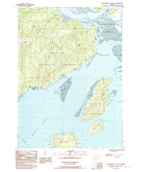
 1992 Petersburg D-4 SE1992 Print · USGSSoutheast Alaska in the early nineties reveals a landscape of protected wilderness and tidal waterways. Researchers can trace remote cabins and drainage networks along Petersburg Creek, Duncan Salt Chuck, and the Petersburg Lake Trail.
 - 1992 Map of Petersburg C-3 SW
 1992 Petersburg C-3 SW1992 Print · USGSSoutheast Alaska’s maritime landscape is captured here in the early nineties, centered on the navigation-critical Wrangell Narrows. Trace the island shorelines and marine landmarks like Beecher Pass State Marine Park, Point Alexander, and the peaks of the Sumner Mountains.
 - 1992 Map of Petersburg D-3 SW
 1992 Petersburg D-3 SW1992 Print · USGSSoutheast Alaska’s maritime character is on full display here in the early nineties, centered on the vital passage of Wrangell Narrows. Genealogists and local historians can trace the streets of Petersburg, find the town Cem, and locate coastal landmarks like Hammer Slough and Sasby Island.
 - 1992 Map of Petersburg C-3 NW
 1992 Petersburg C-3 NW1992 Print · USGSSoutheast Alaska’s maritime corridors come to life in the 1990s as this survey traces the intricate shoreline of the Wrangell Narrows. Genealogists and local historians can locate the Tonka (Site), explore the layout of Papkes Landing, and trace the path of the Mitkof Highway.
 - 1992 Map of Petersburg C-3 NE
 1992 Petersburg C-3 NE1992 Print · USGSMitkof Island in the early nineties features the rugged overlap of the Tongass National Forest and the waters of Frederick Sound. Genealogists and researchers can trace the coastal Petersburg Corporate Boundary and the interior Three Lakes Recreation Area near Sand Lake.
 - 1992 Map of Petersburg C-3 SE
 1992 Petersburg C-3 SE1992 Print · USGSMitkof Island in the early nineties is a portrait of Southeast Alaskan wilderness and infrastructure along the Blind Slough. Researchers can trace the path of the Mitkof Highway to local landmarks like the Crystal Lake Fish Hatchery and Ohmer Creek Campground.
 - 1992 Map of Petersburg C-2 SW
 1992 Petersburg C-2 SW1992 Print · USGSSoutheast Alaska's coastal wilderness comes to life in this early 1990s survey of the intricate islands and straits near Wrangell. Genealogists and historians can trace local landmarks like the Ernie Haugen Public Use Area, the Mitkof Highway, and numerous islands including Rynda Island.
 - 1994 Map of Sumdum A-6, 1998 Print
 1994 Sumdum A-61998 Print · USGSSoutheast Alaska's maritime and forest landscape is captured here in the mid-1990s, showcasing the northern reaches of Kupreanof Island. Researchers can trace old resource extraction sites at various pits or locate navigational landmarks like Turnabout Island and Pinta Pt.
 - 1994 Map of Petersburg D-2, 1998 Print
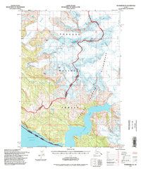 1994 Petersburg D-21998 Print · USGSSoutheast Alaska in the mid-nineties shows a landscape of massive ice fields and tidal fjords within the Tongass National Forest. Researchers can trace the glacial flow of Le Conte Glacier and locate remote shoreline cabins along the edges of Le Conte Bay.
 - 1995 Map of Petersburg D-3
 1995 Petersburg D-31995 Print · USGSSoutheast Alaska's maritime character is on full display in the 1990s as the Alaska Marine Highway connects islands and inlets. Researchers can locate the waterfront footprints of Petersburg, Kupreanof, and Scow Bay or trace inland trails to the Ravens Roost Cabin.
 - 1995 Map of Petersburg B-4, 1999 Print
 1995 Petersburg B-41999 Print · USGSSoutheast Alaska's intricate coastline is mapped during the mid-nineties as a network of maritime passages and timber management zones. Trace remote forest service outposts like the Salmon Bay Lake Cabin (FS) and coastal markers at Point Colpoys.
 - 1995 Map of Petersburg D-6, 1999 Print
 1995 Petersburg D-61999 Print · USGSKupreanof and Kuiu Islands are captured here in the mid-1990s, highlighting the maritime and timber economy of the Alexander Archipelago. Researchers can trace the layout of Kake, find remote sites like Big John Bay Cabin, and locate the Logging Camp Work Center.
 - 1995 Map of Petersburg B-3, 1999 Print
 1995 Petersburg B-31999 Print · USGSZarembo Island and its surrounding straits appear in the mid-nineties as a hub of maritime navigation and forestry work. Researchers can trace the era's coastal infrastructure through the Log Transfer Facility, the Lighthouse Reserve, and the Alaska Marine Highway.
 - 1995 Map of Petersburg B-5, 1999 Print
 1995 Petersburg B-51999 Print · USGSPrince of Wales Island and Kupreanof Island are shown in the mid-nineties during a period of active timber management and coastal settlement. Researchers can trace the layout of the Logging Camp and Log Transfer Facility near Port Protection and the small harbor at Point Baker.
 - 1995 Map of Petersburg C-4, 1999 Print
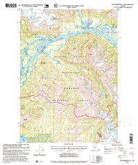
 1995 Petersburg C-41999 Print · USGSKupreanof Island and the Lindenberg Peninsula meet at the Duncan Canal in the mid-nineties. Trace remote backcountry cabins and coastal navigation markers like Castle Flats Cabin, Bluff Light, and Kah Sheets Lake.
 - 1995 Map of Petersburg D-4, 1999 Print
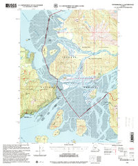
 1995 Petersburg D-41999 Print · USGSSoutheast Alaska in the mid-nineties shows a landscape of deep fjords and maritime industry on Kupreanof Island. Researchers can locate remote outposts like the Logging Camp and Hook Point Cabins, or trace the Portage Mountain Loop Trail.
 - 1995 Map of Petersburg C-1, 1999 Print
 1995 Petersburg C-11999 Print · USGSThe Stikine River delta comes alive in this mid-nineties survey of the Alaskan wilderness. Researchers can trace remote Forest Service outposts like the Mount Rynda Cabin and geothermal landmarks including Chief Shakes Hot Springs.
 - 1995 Map of Port Alexander D-2, 1999 Print
 1995 Port Alexander D-21999 Print · USGSKuiu and Baranof Islands are mapped in the mid-nineties, showing the rugged intersection of Chatham Strait and Frederick Sound. Researchers can trace remote landmarks like the Lighthouse Reserve and Security Bay State Marine Park.
 - 1996 Map of Sumdum B-3, 2000 Print
 1996 Sumdum B-32000 Print · USGSSoutheast Alaska in the late nineties is defined here by massive ice fields and protected wilderness. Trace the intersection of the Dawes Glacier and the Endicott Arm alongside landmarks like Glory Lake and Maury Peak.
 - 1996 Map of Sumdum B-4, 2000 Print
 1996 Sumdum B-42000 Print · USGSSoutheast Alaska's coastal wilderness comes into focus in the mid-nineties, showing the intersection of tidal canals and the Tongass National Forest. Trace the remote shorelines of Port Houghton, finding landmarks like the Chuck River Wilderness and a solitary Cabin on Walter Island.
 - 1997 Map of Port Alexander C-1, 2000 Print
 1997 Port Alexander C-12000 Print · USGSKuiu Island in the late nineties shows a landscape where industrial history meets wilderness preservation. Researchers can trace the remnants of coastal commerce at Pillar Bay Cannery (Abandoned) and find remote outposts like Logging Camp or Monark.
 - 1997 Map of Petersburg C-2, 2000 Print
 1997 Petersburg C-22000 Print · USGSNear Wrangell in the late nineties, the Stikine River delta reveals a rugged landscape of wilderness cabins and silty flats. Researchers can locate remote outposts like Garnet Ledge Cabin (FS) or trace the path of the Ideal Cove Trail along the shoreline.
 - 1997 Map of Port Alexander D-1, 2000 Print
 1997 Port Alexander D-12000 Print · USGSThe northern tip of Kuiu Island comes alive in this late twentieth-century survey of the Alexander Archipelago’s tidal waterways and forest lands. Researchers can locate the site of the Pipeline Cannery (Aband), trace the shoreline of Security Bay, and identify landmarks like Fossil Bluffs.
End of results
Showing maps 1-23 of 23
Top cities of Petersburg Borough
- Petersburg historical maps
- Kake historical maps
- Port Alexander historical maps
- Kupreanof historical maps
Frequently asked questions
- What are the different types of historical maps available for Petersburg Borough?
- What is the oldest map of Petersburg Borough?
- Where can I purchase historical maps of Petersburg Borough for my home or office?
- Where can I download high-res historical maps of Petersburg Borough?
- Are there historical topographic maps available for Petersburg Borough?
- Is there historical aerial imagery available for Petersburg Borough?
- Where are historical maps of Petersburg Borough sourced from?