1950s Maps of Kashegelok, Alaska
Explore 4 historic maps of Kashegelok from the 1950s. These maps offer a rare glimpse into what life looked like during the 1950s — showing old roads, neighborhoods, homes, and landmarks that have changed or disappeared over time.
Whether you're researching your family's past, planning a metal detecting trip, or studying how Kashegelok's landscape evolved across the 1950s, these high-resolution maps are a powerful tool for exploring the history of this region.
- Focus on a specific era: All maps on this page are from the 1950s, giving you a focused view of this time period.
- See what’s changed: Compare century-old streets, trails, and buildings to today's modern landscape using overlays and satellite layers.
- Research with precision: Use these maps for genealogy, historical research, land use analysis, or educational projects.
- View, download, or print: Maps are fully viewable online in high resolution, and can be downloaded or printed for your own records.
Start exploring Kashegelok's history through authentic maps from the 1950s. This is your window into the past.
Kashegelok, AK maps
(4)- 1950 Map of Taylor Mountains, 1959 Print
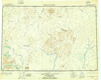
 1950 Taylor Mountains1959 Print · USGSSouthwest Alaska in the mid-twentieth century remains a vast network of glacial lakes and river headwaters before the advent of modern infrastructure. Researchers can trace remote travel routes like the Winter Trail and locate the settlement at Kashegelok.
 - 1951 Map of Taylor Mountains
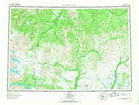
 1951 Taylor Mountains1951 Print · USGSThe Dillingham interior in the early 1950s is defined by vast river networks and the remote Taylor Mountains. Researchers can trace the isolated Kashegelok settlement, the Winter Trail, and the glacial expanse of Tikchik Lake.2 unique versions available
 - 1954 Map of Taylor Mountains, 1967 Print
 1954 Taylor Mountains1967 Print · USGSSouthwestern Alaska in the mid-fifties remains a wilderness of massive glacial lakes and braided river systems. Trace the isolated Tractor Trail through the Taylor Mountains or explore the vast shorelines of Lake Chauekuktuli and Nuyakuk Lake.3 unique versions available
 - 1954 Map of Taylor Mountains D-5, 1968 Print
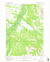 1954 Taylor Mountains D-51968 Print · USGSThe remote Alaska interior in the mid-1950s is defined by its vast river systems and the isolated settlement of Kashegelok. Researchers can trace the drainage of the Nushagak Hills and locate a riverside Cabin and Cem along the Holitna River.
End of results
Showing maps 1-4 of 4
Frequently asked questions
- What are the different types of historical maps available for Kashegelok?
- What is the oldest map of Kashegelok?
- Where can I purchase historical maps of Kashegelok for my home or office?
- Where can I download high-res historical maps of Kashegelok?
- Are there historical topographic maps available for Kashegelok?
- Is there historical aerial imagery available for Kashegelok?
- Where are historical maps of Kashegelok sourced from?