Old Maps of Kashegelok, Alaska for Academic Research
Study the evolution of Kashegelok with 5 high-resolution historic maps. Whether you're teaching, researching, or modeling changes in land use, these maps provide essential visual documentation of urban, environmental, and geographic change.
- Analyze long-term change: Track patterns in development, transportation, and natural features.
- Ideal for environmental or urban studies: Support academic projects with primary historical map data.
- Use in the classroom or lab: Educators and researchers rely on these maps to bring historical context to life.
These maps are a powerful tool for teaching, research, and visualizing how Kashegelok has changed over the decades.
Kashegelok, AK maps
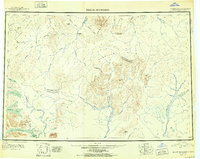
(5)- 1950 Map of Taylor Mountains, 1959 Print
 1950 Taylor Mountains1959 Print · USGSSouthwest Alaska in the mid-twentieth century remains a vast network of glacial lakes and river headwaters before the advent of modern infrastructure. Researchers can trace remote travel routes like the Winter Trail and locate the settlement at Kashegelok.
 - 1951 Map of Taylor Mountains
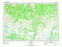
 1951 Taylor Mountains1951 Print · USGSThe Dillingham interior in the early 1950s is defined by vast river networks and the remote Taylor Mountains. Researchers can trace the isolated Kashegelok settlement, the Winter Trail, and the glacial expanse of Tikchik Lake.2 unique versions available
 - 1954 Map of Taylor Mountains, 1967 Print
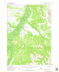
 1954 Taylor Mountains1967 Print · USGSSouthwestern Alaska in the mid-fifties remains a wilderness of massive glacial lakes and braided river systems. Trace the isolated Tractor Trail through the Taylor Mountains or explore the vast shorelines of Lake Chauekuktuli and Nuyakuk Lake.3 unique versions available
 - 1954 Map of Taylor Mountains D-5, 1968 Print
 1954 Taylor Mountains D-51968 Print · USGSThe remote Alaska interior in the mid-1950s is defined by its vast river systems and the isolated settlement of Kashegelok. Researchers can trace the drainage of the Nushagak Hills and locate a riverside Cabin and Cem along the Holitna River.
 - 2019 Map of Taylor Mountains D-5 SW, 2019 Print
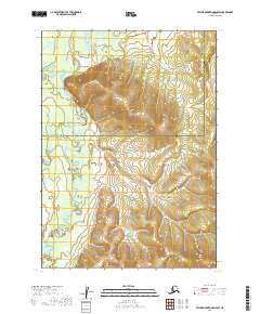 2019 Taylor Mountains D-5 SW2019 Print · USGSThe remote Alaskan interior near the border of the Bethel and Dillingham census areas is captured here in 2019. Trace the winding courses of the Holitna River and Kogrukluk River near the settlement of Kashegelok.
End of results
Showing maps 1-5 of 5
Frequently asked questions
- What are the different types of historical maps available for Kashegelok?
- What is the oldest map of Kashegelok?
- Where can I purchase historical maps of Kashegelok for my home or office?
- Where can I download high-res historical maps of Kashegelok?
- Are there historical topographic maps available for Kashegelok?
- Is there historical aerial imagery available for Kashegelok?
- Where are historical maps of Kashegelok sourced from?