
1951 Map of Taylor Mountains
USGS Topo · Published 1951About this map
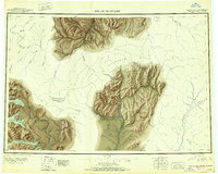
The Taylor Mountains dominate this 1951 study of the Alaskan interior, representing a landscape defined by expansive drainage basins and the divide between the Kuskokwim River and the Nushagak River. In the northern reaches, the small settlement of Kashegelok sits along the Holitna River, while a single Winter Trail cuts across the northwest corner near Atsaksovluk Creek. The map captures a moment of administrative transition, clearly marking the boundary between the Fourth and Third Judicial Divisions. Toward the south, the terrain gives way to a massive lake system including Tikchik Lake, Upnuk Lake, and Chikuminuk Lake, punctuated by landmarks like Ongutvak Mtn and Tikchik Mtn. The presence of Cinnabar Creek and various rapids along the Salmon River indicates the early focus on water-based travel and mineral potential in this part of the Dillingham region.
Find a feature on this map
54 named features on this map. Tap any name to fly to it.
Don’t see what you’re looking for? This feature index may not catch every label — zoom into the map to look around manually.
Map Details
Editions of this 1951 Taylor Mountains Map
2 editions found
Other maps of this area

1946 · Lake Clark
USGS Topo · 1:250,000

1947 · Russian Mission
USGS Topo · 1:250,000

1950 · Russian Mission
USGS Topo · 1:250,000

1950 · Sleetmute
USGS Topo · 1:250,000

1950 · Bethel
USGS Topo · 1:250,000

1950 · Taylor Mountains
USGS Topo · 1:250,000

1951 · Lake Clark
USGS Topo · 1:250,000

1951 · Lime Hills
USGS Topo · 1:250,000

1951 · Dillingham
USGS Topo · 1:250,000

1951 · Goodnews
USGS Topo · 1:250,000