Old Maps of Kashegelok, Alaska for Metal Detecting
Plan your next treasure hunt with 5 historic maps of Kashegelok. Find old homesites, ghost towns, trails, and gathering spots that may be lost to time — perfect for identifying promising metal detecting locations.
- Locate forgotten sites: Uncover places like long-lost settlements, abandoned rail lines, or gathering spots.
- Plan better hunts: Use map overlays combined with LiDAR or satellite views to narrow in on historically rich areas.
- Made for detectorists: Thousands of hobbyists use these maps to discover relics, coins, and hidden history.
Use these historic maps to boost your research and find new opportunities beneath the surface of Kashegelok.
Kashegelok, AK maps
(5)- 1950 Map of Taylor Mountains, 1959 Print
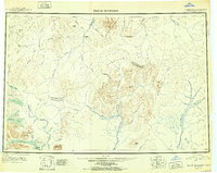
 1950 Taylor Mountains1959 Print · USGSSouthwest Alaska in the mid-twentieth century remains a vast network of glacial lakes and river headwaters before the advent of modern infrastructure. Researchers can trace remote travel routes like the Winter Trail and locate the settlement at Kashegelok.
 - 1951 Map of Taylor Mountains
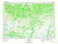
 1951 Taylor Mountains1951 Print · USGSThe Dillingham interior in the early 1950s is defined by vast river networks and the remote Taylor Mountains. Researchers can trace the isolated Kashegelok settlement, the Winter Trail, and the glacial expanse of Tikchik Lake.2 unique versions available
 - 1954 Map of Taylor Mountains, 1967 Print
 1954 Taylor Mountains1967 Print · USGSSouthwestern Alaska in the mid-fifties remains a wilderness of massive glacial lakes and braided river systems. Trace the isolated Tractor Trail through the Taylor Mountains or explore the vast shorelines of Lake Chauekuktuli and Nuyakuk Lake.3 unique versions available
 - 1954 Map of Taylor Mountains D-5, 1968 Print
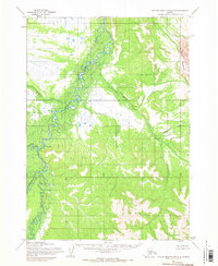 1954 Taylor Mountains D-51968 Print · USGSThe remote Alaska interior in the mid-1950s is defined by its vast river systems and the isolated settlement of Kashegelok. Researchers can trace the drainage of the Nushagak Hills and locate a riverside Cabin and Cem along the Holitna River.
 - 2019 Map of Taylor Mountains D-5 SW, 2019 Print
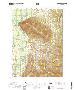 2019 Taylor Mountains D-5 SW2019 Print · USGSThe remote Alaskan interior near the border of the Bethel and Dillingham census areas is captured here in 2019. Trace the winding courses of the Holitna River and Kogrukluk River near the settlement of Kashegelok.
End of results
Showing maps 1-5 of 5
Frequently asked questions
- What are the different types of historical maps available for Kashegelok?
- What is the oldest map of Kashegelok?
- Where can I purchase historical maps of Kashegelok for my home or office?
- Where can I download high-res historical maps of Kashegelok?
- Are there historical topographic maps available for Kashegelok?
- Is there historical aerial imagery available for Kashegelok?
- Where are historical maps of Kashegelok sourced from?