1970s Maps of Chukut Kuk District, Arizona
Explore 8 historic maps of Chukut Kuk District from the 1970s. These maps offer a rare glimpse into what life looked like during the 1970s — showing old roads, neighborhoods, homes, and landmarks that have changed or disappeared over time.
Whether you're researching your family's past, planning a metal detecting trip, or studying how Chukut Kuk District's landscape evolved across the 1970s, these high-resolution maps are a powerful tool for exploring the history of this region.
- Focus on a specific era: All maps on this page are from the 1970s, giving you a focused view of this time period.
- See what’s changed: Compare century-old streets, trails, and buildings to today's modern landscape using overlays and satellite layers.
- Research with precision: Use these maps for genealogy, historical research, land use analysis, or educational projects.
- View, download, or print: Maps are fully viewable online in high resolution, and can be downloaded or printed for your own records.
Start exploring Chukut Kuk District's history through authentic maps from the 1970s. This is your window into the past.
Chukut Kuk District, AZ maps
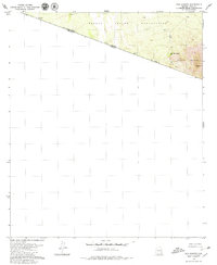
(8)- 1979 Map of San Miguel
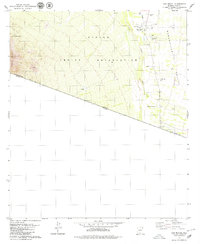 1979 San Miguel1979 Print · USGSThe Papago Indian Reservation and the Baboquivari Valley meet the international border in the late seventies. Researchers can trace remote desert settlements and essential water infrastructure at San Miguel, Hashan Chuehg, and the Queen of Angels Mission.2 unique versions available
 - 1979 Map of Caponera Peak
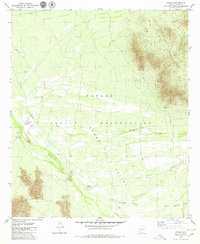
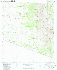 1979 Caponera Peak1979 Print · USGSIn the late seventies, this section of the Arizona-Mexico border reveals a network of indigenous sites and high-desert landmarks. Researchers can trace the Los Encinos Trail, locate the Buenos Aires Ruins, and find isolated village sites like Nachi Kulik.3 unique versions available
 - 1979 Map of South Komelik
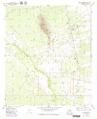 1979 South Komelik1979 Print · USGSThe Papago Indian Reservation is captured in the late seventies, showing a landscape of desert washes and isolated peaks. Trace ancestral roots and desert life near South Komelik, Choulic, and the cemeteries at Supi Oidak.
 - 1979 Map of Aguirre Peak
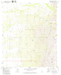 1979 Aguirre Peak1979 Print · USGSThe Papago Indian Reservation in the late seventies reveals a landscape of desert washes and high peaks. Genealogists and local historians can locate early settlement sites like Kuit Vaya (Site) and family-named landmarks such as Charlo Juan Well.3 unique versions available
 - 1979 Map of San Agustin
 1979 San Agustin1979 Print · USGSThe Arizona-Sonora borderlands come into focus in the late seventies, showing the remote desert reaches of the Papago Indian Reservation. Researchers can trace old routes like the Jeep Trail leading toward Morena Mountain and the San Agustin well.
 - 1979 Map of Cowlic, 1980 Print
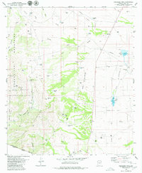
 1979 Cowlic1980 Print · USGSThe Papago Indian Reservation in the late seventies reveals a landscape of desert ranching and traditional Tohono O'odham settlements. Researchers can trace the layout of Cowlic, find the Cem, and locate the historic Vopolo Havoka (Site) near the Alvarez Mts.2 unique versions available
 - 1979 Map of Presumido Peak, 1980 Print
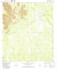
 1979 Presumido Peak1980 Print · USGSThe high-desert borderlands of Pima County are shown here in the late 1970s, as ranching culture remained the primary influence on the landscape. Genealogists and historians can trace family-named outposts and water features like Buenos Aires Ranch, Aros Ranch, and McGrail Tank.2 unique versions available
 - 1979 Map of Vamori, 1980 Print
 1979 Vamori1980 Print · USGSThe high desert of the Pima borderlands is captured here in the late seventies, showing the traditional settlements of the Tohono O'odham people. Researchers can trace the layout of Vamori and Itak, and find landmarks like Ram Boo Ranch and Wamul Tank.
End of results
Showing maps 1-8 of 8
Top cities near Chukut Kuk District
Top neighborhoods of Chukut Kuk District
- San Rafael historical maps
- San Miguel historical maps
- Sivili Chuchg historical maps
- Haivan Vaya historical maps
- Tatkum Vo historical maps
- San Agustin historical maps
See more
Frequently asked questions
- What are the different types of historical maps available for Chukut Kuk District?
- What is the oldest map of Chukut Kuk District?
- Where can I purchase historical maps of Chukut Kuk District for my home or office?
- Where can I download high-res historical maps of Chukut Kuk District?
- Are there historical topographic maps available for Chukut Kuk District?
- Is there historical aerial imagery available for Chukut Kuk District?
- Where are historical maps of Chukut Kuk District sourced from?