1930s Maps of Santa Cruz County, Arizona
Explore 6 historic maps of Santa Cruz County from the 1930s. These maps offer a rare glimpse into what life looked like during the 1930s — showing old roads, neighborhoods, homes, and landmarks that have changed or disappeared over time.
Whether you're researching your family's past, planning a metal detecting trip, or studying how Santa Cruz County's landscape evolved across the 1930s, these high-resolution maps are a powerful tool for exploring the history of this region.
- Focus on a specific era: All maps on this page are from the 1930s, giving you a focused view of this time period.
- See what’s changed: Compare century-old streets, trails, and buildings to today's modern landscape using overlays and satellite layers.
- Research with precision: Use these maps for genealogy, historical research, land use analysis, or educational projects.
- View, download, or print: Maps are fully viewable online in high resolution, and can be downloaded or printed for your own records.
Start exploring Santa Cruz County's history through authentic maps from the 1930s. This is your window into the past.
Santa Cruz County, AZ maps
(6)- 1932 Map of Lochiel
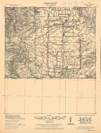 1932 Lochiel1932 Print · USGSThe Arizona-Mexico borderlands come alive in this early 1930s survey of the high desert and San Rafael Valley. Researchers can trace family ranching legacies at Stevensons Ranch or explore the mining history of The Mowry Mine and Harshaw.2 unique versions available
 - 1932 Map of Elgin
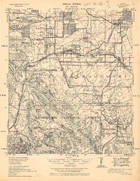 1932 Elgin1932 Print · USGSSanta Cruz County ranching culture is on full display in the early 1930s as the Southern Pacific rail line winds through the high desert. Genealogists can trace family landmarks like Gardner's Ranch and Turner-Bower Ranch or locate the site of Old Ft Crittenden.
 - 1933 Map of Calabasas
 1933 Calabasas1933 Print · USGSNogales and the Santa Cruz River valley are shown here in the 1930s, documenting a critical era of border history and ranching. Trace early landmarks like Camp Stephen D. Little, the 3R Mine, and historic family lands at Buena Vista Ranch.2 unique versions available
 - 1938 Map of Huachuca
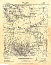 1938 Huachuca1938 Print · USGSSoutheastern Arizona's military and ranching landscape is captured here in the late thirties, centered on the historic Fort Huachuca. Genealogists and historians can trace early family holdings like Pyeatt Ranch and Mc Beanes, or locate the Manua Panama Mine and the Evans School.
 - 1938 Map of Sunnyside
 1938 Sunnyside1938 Print · USGSThe Arizona borderlands near the Santa Cruz and Cochise county line are shown here in the years before the second World War. Researchers can trace the layout of Fort Huachuca and locate remote outposts like the Montezuma Mine, Sunnyside, and the R.O. Cattle Co.2 unique versions available
 - 1939 Map of Tubac, 1956 Print
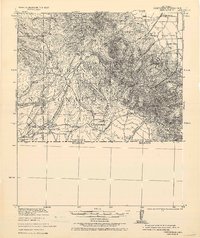
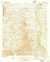 1939 Tubac1956 Print · USGSSouthern Arizona ranching and valley life come into focus just before the war, centered on the Santa Cruz River corridor. Genealogists and historians can trace family locations from the Santa Lucia Ranch to Arivaca Junction, and locate the Sopori Sch near Amado.
End of results
Showing maps 1-6 of 6
Top cities of Santa Cruz County
- Nogales historical maps
- Town of Patagonia historical maps
- Sonoita historical maps
- Amado historical maps
Frequently asked questions
- What are the different types of historical maps available for Santa Cruz County?
- What is the oldest map of Santa Cruz County?
- Where can I purchase historical maps of Santa Cruz County for my home or office?
- Where can I download high-res historical maps of Santa Cruz County?
- Are there historical topographic maps available for Santa Cruz County?
- Is there historical aerial imagery available for Santa Cruz County?
- Where are historical maps of Santa Cruz County sourced from?