1970s Maps of Santa Cruz County, Arizona
Explore 2 historic maps of Santa Cruz County from the 1970s. These maps offer a rare glimpse into what life looked like during the 1970s — showing old roads, neighborhoods, homes, and landmarks that have changed or disappeared over time.
Whether you're researching your family's past, planning a metal detecting trip, or studying how Santa Cruz County's landscape evolved across the 1970s, these high-resolution maps are a powerful tool for exploring the history of this region.
- Focus on a specific era: All maps on this page are from the 1970s, giving you a focused view of this time period.
- See what’s changed: Compare century-old streets, trails, and buildings to today's modern landscape using overlays and satellite layers.
- Research with precision: Use these maps for genealogy, historical research, land use analysis, or educational projects.
- View, download, or print: Maps are fully viewable online in high resolution, and can be downloaded or printed for your own records.
Start exploring Santa Cruz County's history through authentic maps from the 1970s. This is your window into the past.
Santa Cruz County, AZ maps
(2)- 1979 Map of Bartlett Mtn
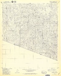 1979 Bartlett Mtn1979 Print · USGSThe Arizona-Mexico borderlands come into focus in the late seventies, showing a landscape defined by ranching and a legacy of mining. Trace remote operations like the Yellow Jacket Mine, find the El Oro Cemetery, and locate the Old Mill Site near Warsaw Canyon.4 unique versions available
 - 1979 Map of Arivaca, 1980 Print
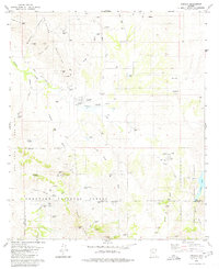 1979 Arivaca1980 Print · USGSArivaca and the surrounding high desert cattle country are captured here in the late seventies as the region balanced its mining past with modern ranching. Researchers can locate family landmarks like Honnas Ranch, the local Cem, and historical workings including the Amado Mine.2 unique versions available
End of results
Showing maps 1-2 of 2
Top cities of Santa Cruz County
- Nogales historical maps
- Town of Patagonia historical maps
- Sonoita historical maps
- Amado historical maps
Frequently asked questions
- What are the different types of historical maps available for Santa Cruz County?
- What is the oldest map of Santa Cruz County?
- Where can I purchase historical maps of Santa Cruz County for my home or office?
- Where can I download high-res historical maps of Santa Cruz County?
- Are there historical topographic maps available for Santa Cruz County?
- Is there historical aerial imagery available for Santa Cruz County?
- Where are historical maps of Santa Cruz County sourced from?