1980s Maps of Santa Cruz County, Arizona
Explore 16 historic maps of Santa Cruz County from the 1980s. These maps offer a rare glimpse into what life looked like during the 1980s — showing old roads, neighborhoods, homes, and landmarks that have changed or disappeared over time.
Whether you're researching your family's past, planning a metal detecting trip, or studying how Santa Cruz County's landscape evolved across the 1980s, these high-resolution maps are a powerful tool for exploring the history of this region.
- Focus on a specific era: All maps on this page are from the 1980s, giving you a focused view of this time period.
- See what’s changed: Compare century-old streets, trails, and buildings to today's modern landscape using overlays and satellite layers.
- Research with precision: Use these maps for genealogy, historical research, land use analysis, or educational projects.
- View, download, or print: Maps are fully viewable online in high resolution, and can be downloaded or printed for your own records.
Start exploring Santa Cruz County's history through authentic maps from the 1980s. This is your window into the past.
Santa Cruz County, AZ maps
(16)- 1980 Map of Alamo Spring
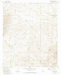
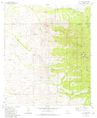
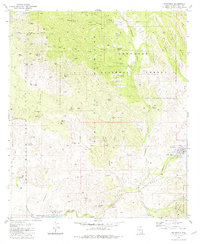
 1980 Alamo Spring1980 Print · USGSThe Arizona-Mexico border landscape is documented here in the early 1980s, showcasing the high-desert terrain of the Pajarito Mountains. Local historians can trace named ranch sites and water tanks from Rancho and Los Adobes to the remote Alamo Spring.
 - 1981 Map of Saucito Mtn.
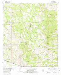
 1981 Saucito Mtn.1981 Print · USGSSouthern Arizona ranching and forest lands are documented here in the early eighties as they straddle the Pima and Santa Cruz county lines. Researchers can locate the Old Sopori School, trace the Arivaca Road, and find family-named sites like Santa Lucia Ranch.2 unique versions available
 - 1981 Map of Cumero Canyon
 1981 Cumero Canyon1981 Print · USGSThe high desert of Santa Cruz County comes to life in the early eighties as ranching traditions meet a legacy of mountain mining. Genealogists and historians can trace the Circle Z Ranch, Santa Cruz School, and dozens of mines like the Three R Mine.3 unique versions available
 - 1981 Map of Rio Rico
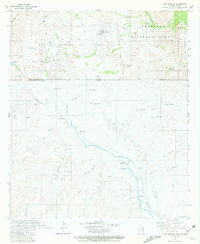
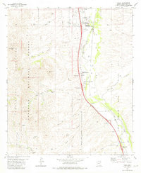
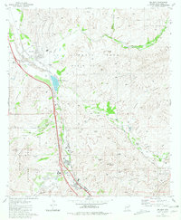 1981 Rio Rico1981 Print · USGSSouthern Arizona’s Santa Cruz Valley comes into focus in the early 1980s, showcasing a landscape where ancient Spanish colonial history meets modern ranching and industry. Researchers can find the historic Guevavi Mission (Ruins), old workings like the Lion Mine, and the sprawling Luis Maria Baca land grant.2 unique versions available
 - 1981 Map of Pajarito Peak
 1981 Pajarito Peak1981 Print · USGSThe Arizona-Sonora borderlands come into focus in the early eighties, documenting the remote canyons and mining claims of the Santa Cruz region. Researchers can trace the ranching life and mineral hunts through labels like the Big Steve Mine, Adobe Spring (Dry), and La Recompensa.2 unique versions available
 - 1981 Map of Mt. Wrightson
 1981 Mt. Wrightson1981 Print · USGSThe Santa Rita Mountains of the early eighties are mapped here in detail, showcasing a rugged mining and recreation landscape. Researchers can trace the legacy of mineral claims at the Florida Mine, explore the heights of Mt Wrightson, or locate subterranean features like Onyx Cave.2 unique versions available
 - 1981 Map of Pena Blanca Lake
 1981 Pena Blanca Lake1981 Print · USGSThe rugged Santa Cruz County backcountry is captured here in the early eighties, centered on the Peña Blanca Lake recreation area and surrounding peaks. Researchers can locate remote ranching infrastructure and mineral sites like the Morning Mine, St Patrick Mine, and Cumming Ranch.
 - 1981 Map of Amado
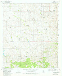
 1981 Amado1981 Print · USGSIn the Santa Cruz River valley during the early eighties, ranching and desert travel defined the landscape. Genealogists and historians can trace family operations at Sopori Ranch, the rural Sopori Sch, and the rail stops of the Southern Pacific.2 unique versions available
 - 1981 Map of Mt. Hopkins
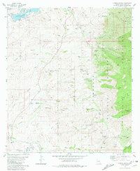
 1981 Mt. Hopkins1981 Print · USGSThe Santa Rita Mountains of Southern Arizona are captured in the early eighties as a hub of both scientific research and historic mining operations. Researchers can trace dozens of prospect sites and established mines like the Montosa Mine or locate the Agua Caliente Caves and Proctor Ranch.3 unique versions available
 - 1981 Map of Kino Springs
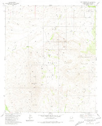
 1981 Kino Springs1981 Print · USGSThe high-desert borderlands of southern Arizona and Sonora are mapped here in the early eighties, showing the vital flow of the Santa Cruz River across the international line. Trace historic ranching sites and outposts like Buena Vista Ranch, San Rafael, and the remote Kino Springs.
 - 1981 Map of San Cayetano Mts.
 1981 San Cayetano Mts.1981 Print · USGSSouthern Arizona’s high desert peaks and land grant boundaries are preserved here during the early eighties. Genealogists and historians can trace the remote Salero Ranch, find the Tubutama Mine, or locate a small Cem near the Grosvenor Hills.3 unique versions available
 - 1981 Map of Murphy Peak
 1981 Murphy Peak1981 Print · USGSArizona's high desert ranching country is captured here in the early 1980s, where the Pima and Santa Cruz county lines meet. Researchers can trace land use through named water improvements and topographical features like Arivaca Lake, Murphy Peak, and Red Spring Pass.2 unique versions available
 - 1981 Map of Patagonia
 1981 Patagonia1981 Print · USGSThe Santa Rita Mountains of southern Arizona were a hive of mineral exploration and ranching in the early eighties. Researchers can trace historic claims like the Happy Jack Mine, visit the Alto site, or locate family landmarks such as Weatherhead Ranch.2 unique versions available
 - 1981 Map of Nogales
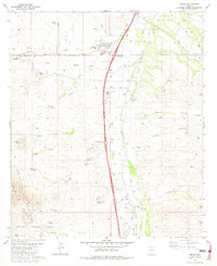
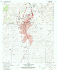 1981 Nogales1981 Print · USGSThe international border at Nogales is captured here in the early eighties, showing a seamless urban flow between Arizona and Sonora. Genealogists can trace family footprints through numerous neighborhoods and schools like Mitchell Sch and Our Lady of Lourdes Academy.
 - 1981 Map of Tubac
 1981 Tubac1981 Print · USGSThe Santa Cruz River valley in the early eighties shows a landscape shaped by both colonial roots and modern ranching. Genealogists can trace family holdings at Kenyon Ranch or locate local institutions like the Calabasas Sch and Tumacacori National Monument.3 unique versions available
 - 1981 Map of Ruby
 1981 Ruby1981 Print · USGSThe Arizona-Mexico borderlands come into focus in the early 1980s, centered on the mining district of Ruby and the Tumacacori Mountains. Genealogists and historians can trace the foundations of the regional economy through the Montana Mine and Atascosa Trail Ranch.3 unique versions available
End of results
Showing maps 1-16 of 16
Top cities of Santa Cruz County
- Nogales historical maps
- Town of Patagonia historical maps
- Sonoita historical maps
- Amado historical maps
Frequently asked questions
- What are the different types of historical maps available for Santa Cruz County?
- What is the oldest map of Santa Cruz County?
- Where can I purchase historical maps of Santa Cruz County for my home or office?
- Where can I download high-res historical maps of Santa Cruz County?
- Are there historical topographic maps available for Santa Cruz County?
- Is there historical aerial imagery available for Santa Cruz County?
- Where are historical maps of Santa Cruz County sourced from?