1930s Maps of Yuma County, Arizona
Explore 7 historic maps of Yuma County from the 1930s. These maps offer a rare glimpse into what life looked like during the 1930s — showing old roads, neighborhoods, homes, and landmarks that have changed or disappeared over time.
Whether you're researching your family's past, planning a metal detecting trip, or studying how Yuma County's landscape evolved across the 1930s, these high-resolution maps are a powerful tool for exploring the history of this region.
- Focus on a specific era: All maps on this page are from the 1930s, giving you a focused view of this time period.
- See what’s changed: Compare century-old streets, trails, and buildings to today's modern landscape using overlays and satellite layers.
- Research with precision: Use these maps for genealogy, historical research, land use analysis, or educational projects.
- View, download, or print: Maps are fully viewable online in high resolution, and can be downloaded or printed for your own records.
Start exploring Yuma County's history through authentic maps from the 1930s. This is your window into the past.
Yuma County, AZ maps
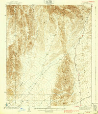
(7)- 1930 Map of Aguila Mountains
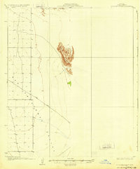 1930 Aguila Mountains1930 Print · USGSIn the Yuma County desert during the late 1920s, this survey captures a landscape of extreme verticality and open space. Researchers can trace early desert transit along the Yager Road or study the terrain surrounding the Aguila Mountains and Aztec Hills.3 unique versions available
 - 1930 Map of Stoval
 1930 Stoval1930 Print · USGSYuma County during the late twenties reveals a desert landscape organized around the Southern Pacific railroad and the Gila River. Genealogists and historians can locate old stops and sidings like Kofa Sta, Le Sage, and Stoval along the historic Old Palomas Yuma Road.4 unique versions available
 - 1930 Map of Hyder
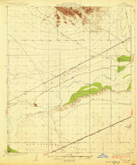
 1930 Hyder1930 Print · USGSArid desert landscapes in Yuma County are captured here just before the 1930s, showing a critical crossroads for early rail and road travel. Genealogists and historians can trace the Southern Pacific line through Hyder and locate early landmarks like Morris Ranch and Hall Well.3 unique versions available
 - 1931 Map of Kim
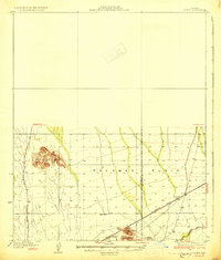
 1931 Kim1931 Print · USGSYuma County’s desert corridor appears here during the early thirties, defined by the isolated railroad stop at Kim. Researchers can trace the early desert travel routes like Yager Road and locate critical historic water stops such as Pimoria Well and White Well.3 unique versions available
 - 1934 Map of Trigo Peaks
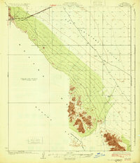
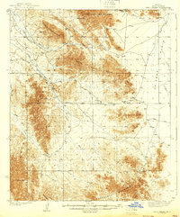
 1934 Trigo Peaks1934 Print · USGSThe arid reaches of western Arizona appear as they were in the early thirties, during the height of desert surveying. Trace the historical Cibola Road past the Tweed Mine and through the rugged Felipe Pass.
 - 1939 Map of Red Hill
 1939 Red Hill1939 Print · USGSThe high desert of Yuma County is mapped here in the mid-1930s, showing a landscape defined by mining prospects and historic transit routes. You can trace early desert roads and name points like the Annie Mine, Red Hill, and the long Quartzite Yuma Road.3 unique versions available
 - 1939 Map of Trigo Peaks
 1939 Trigo Peaks1939 Print · USGSArizona's high desert reveals its raw geography in the 1930s, showing a landscape defined by mountain corridors and seasonal washes. Researchers can trace early desert transit along the Cibola Road and locate remote industrial sites like the Tweed Mine.2 unique versions available
End of results
Showing maps 1-7 of 7
Top cities of Yuma County
- Yuma historical maps
- Fortuna Foothills historical maps
- San Luis historical maps
- Somerton historical maps
- Avenue B & C historical maps
- Wellton historical maps
See more
Frequently asked questions
- What are the different types of historical maps available for Yuma County?
- What is the oldest map of Yuma County?
- Where can I purchase historical maps of Yuma County for my home or office?
- Where can I download high-res historical maps of Yuma County?
- Are there historical topographic maps available for Yuma County?
- Is there historical aerial imagery available for Yuma County?
- Where are historical maps of Yuma County sourced from?