1980s Maps of Yell County, Arkansas
Explore 12 historic maps of Yell County from the 1980s. These maps offer a rare glimpse into what life looked like during the 1980s — showing old roads, neighborhoods, homes, and landmarks that have changed or disappeared over time.
Whether you're researching your family's past, planning a metal detecting trip, or studying how Yell County's landscape evolved across the 1980s, these high-resolution maps are a powerful tool for exploring the history of this region.
- Focus on a specific era: All maps on this page are from the 1980s, giving you a focused view of this time period.
- See what’s changed: Compare century-old streets, trails, and buildings to today's modern landscape using overlays and satellite layers.
- Research with precision: Use these maps for genealogy, historical research, land use analysis, or educational projects.
- View, download, or print: Maps are fully viewable online in high resolution, and can be downloaded or printed for your own records.
Start exploring Yell County's history through authentic maps from the 1980s. This is your window into the past.
Yell County, AR maps
(12)- 1982 Map of Lake Ouachita
 1982 Lake Ouachita1982 Print · USGSThe Ouachita Mountains of West Central Arkansas are shown here during the early eighties, a time of established recreation and protected timberlands. Researchers can locate small communities like Buckville (PO) and Pencil Bluff or trace the drainage of the Fourche La Fave River.
 - 1983 Map of Conway, 1984 Print
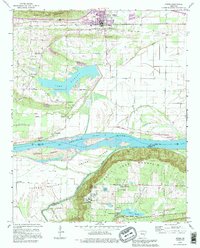
 1983 Conway1984 Print · USGSThe Arkansas River valley in the early eighties shows a landscape of river-bend settlements and expanding wildlife areas. Genealogists and historians can trace the Missouri Pacific RR through old river towns like Toad Suck, Morrilton, and Menifee.
 - 1984 Map of Russellville
 1984 Russellville1984 Print · USGSThe Arkansas River valley in the mid-eighties shows a landscape defined by the rise of Lake Dardanelle and the enduring presence of the Ozark National Forest. Researchers can find historical institutions like Arkansas Tech Univ and Sacred Heart Church or trace the routes of the Missouri Pacific RR.2 unique versions available
 - 1984 Map of Russellville
 1984 Russellville1984 Print · USGSThe Arkansas River valley was undergoing significant change in the 1950s as transportation and water management reshaped the region from Russellville to Conway. Researchers can trace the era's rail networks like the Missouri Pacific RR and explore landmarks like Magazine Mountain and Petit Jean State Park.
 - 1985 Map of Gravelly, 1986 Print
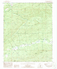
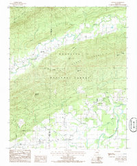 1985 Gravelly1986 Print · USGSThe Fourche La Fave River valley of Yell County comes to life in this mid-1980s survey. Genealogists and local historians can trace small settlements like Gravelly, Blue Ball, and Nola as they existed before modern development altered the rural landscape.
 - 1985 Map of Little Texas, 1986 Print
 1985 Little Texas1986 Print · USGSThe northern Ouachitas in the mid-eighties show a landscape of dense timber and protected wildlife areas along the Fourche La Fave River. Local historians can trace the small settlement of Little Texas or locate regional landmarks like the Shale Pit and Ganders Peak.
 - 1985 Map of Bluffton, 1986 Print
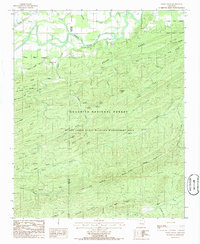
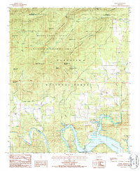
 1985 Bluffton1986 Print · USGSYell County in the mid-1980s is shown here as a landscape of forest ridges and river-valley settlements. Local researchers can trace family lands near Bluffton, Waltreak, and the mineral waters of Chalybeate Springs along Dutch Creek.
 - 1986 Map of Sims
 1986 Sims1986 Print · USGSThe Ouachita River valley comes to life in the mid-1980s, showing the intersection of national forest lands and rural Montgomery County settlements. Genealogists and hikers can trace local landmarks like Sims, the Harris Trail, and the Lookout Tower atop Muddy Mountain.
 - 1986 Map of Chula Mountain
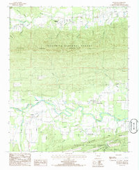
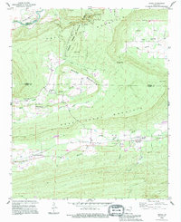
 1986 Chula Mountain1986 Print · USGSYell County, Arkansas, is shown during the mid-1980s as a landscape of remote mountain ridges and managed forest land. Genealogists and local historians can locate the community of Chula and its nearby Cem, or trace family landmarks like Miller Ranch Creek and Brantley Ranch Creek.
 - 1986 Map of Story
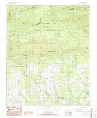
 1986 Story1986 Print · USGSThe northern waters of Lake Ouachita and the surrounding forest highlands are captured here in the mid-eighties. Genealogists and local historians can locate early settlements like Story and Washita or trace family landmarks such as Harold Ridge and the Cem near Gibbs.
 - 1989 Map of Adona, 1995 Print
 1989 Adona1995 Print · USGSThe northern ridges of Perry and Conway counties are captured here in the late eighties, centered on the communities of Adona and Ada. Researchers can locate several family cemeteries, Rock House Cave, and the Welcome Home Ch.
 - 1989 Map of Atkins, 1995 Print
 1989 Atkins1995 Print · USGSThe Arkansas River valley near Atkins is shown in the late eighties as it transitions from the fertile Carden Bottom to the heights of Petit Jean Mountain. Genealogists and historians can trace local landmarks like Bells Chapel Cem, Gold Hill Sch, and the riverside community of Winrock.
End of results
Showing maps 1-12 of 12
Top cities of Yell County
- Dardanelle historical maps
- Danville historical maps
- Ola historical maps
- Plainview historical maps
- Belleville historical maps
- Havana historical maps
See more
Frequently asked questions
- What are the different types of historical maps available for Yell County?
- What is the oldest map of Yell County?
- Where can I purchase historical maps of Yell County for my home or office?
- Where can I download high-res historical maps of Yell County?
- Are there historical topographic maps available for Yell County?
- Is there historical aerial imagery available for Yell County?
- Where are historical maps of Yell County sourced from?