1990s Maps of Yell County, Arkansas
Explore 5 historic maps of Yell County from the 1990s. These maps offer a rare glimpse into what life looked like during the 1990s — showing old roads, neighborhoods, homes, and landmarks that have changed or disappeared over time.
Whether you're researching your family's past, planning a metal detecting trip, or studying how Yell County's landscape evolved across the 1990s, these high-resolution maps are a powerful tool for exploring the history of this region.
- Focus on a specific era: All maps on this page are from the 1990s, giving you a focused view of this time period.
- See what’s changed: Compare century-old streets, trails, and buildings to today's modern landscape using overlays and satellite layers.
- Research with precision: Use these maps for genealogy, historical research, land use analysis, or educational projects.
- View, download, or print: Maps are fully viewable online in high resolution, and can be downloaded or printed for your own records.
Start exploring Yell County's history through authentic maps from the 1990s. This is your window into the past.
Yell County, AR maps
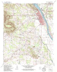
(5)- 1992 Map of Russellville, 1993 Print
 1992 Russellville1993 Print · USGSCentral Arkansas in the early nineties shows a landscape defined by the Arkansas River valley and the surrounding national forests. Trace the development of river towns like Russellville and Dardanelle alongside landmarks such as Lake Dardanelle and Magazine Mtn.
 - 1993 Map of Russellville West
 1993 Russellville West1993 Print · USGSRussellville and the Arkansas River valley are captured in the early nineties as the city grew around Arkansas Tech University. Local historians can trace the Old Indian Treaty Boundary and locate family landmarks like Booher Cem and Damascus Ch.
 - 1993 Map of Delaware
 1993 Delaware1993 Print · USGSThe Arkansas River valley near the Ozark foothills comes into focus in the early nineties, showing a landscape defined by the expansive Lake Dardanelle. Genealogists and researchers can trace an Old Railroad Grade and locate numerous family burial sites like Hon Cem and Garrison Cem.
 - 1993 Map of Dardanelle
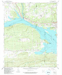
 1993 Dardanelle1993 Print · USGSThe Arkansas River valley comes alive in the early 1990s as the riverfront hubs of Dardanelle and Russellville expanded around the lock and dam. Genealogists can trace family names at Brearley Cem and Louvenia Cem or locate the old Gum Springs Cumberland Ch.
 - 1993 Map of Holla Bend
 1993 Holla Bend1993 Print · USGSThe Arkansas River bottomlands in the early nineties show a landscape of conservation and river engineering. Genealogists and local historians can trace family burial sites like Shinn Cem and Pearson Cem or locate rural landmarks like Carden Bottom Ch.
End of results
Showing maps 1-5 of 5
Top cities of Yell County
- Dardanelle historical maps
- Danville historical maps
- Ola historical maps
- Plainview historical maps
- Belleville historical maps
- Havana historical maps
See more
Frequently asked questions
- What are the different types of historical maps available for Yell County?
- What is the oldest map of Yell County?
- Where can I purchase historical maps of Yell County for my home or office?
- Where can I download high-res historical maps of Yell County?
- Are there historical topographic maps available for Yell County?
- Is there historical aerial imagery available for Yell County?
- Where are historical maps of Yell County sourced from?