1930s Maps of Coalinga, California
Explore 6 historic maps of Coalinga from the 1930s. These maps offer a rare glimpse into what life looked like during the 1930s — showing old roads, neighborhoods, homes, and landmarks that have changed or disappeared over time.
Whether you're researching your family's past, planning a metal detecting trip, or studying how Coalinga's landscape evolved across the 1930s, these high-resolution maps are a powerful tool for exploring the history of this region.
- Focus on a specific era: All maps on this page are from the 1930s, giving you a focused view of this time period.
- See what’s changed: Compare century-old streets, trails, and buildings to today's modern landscape using overlays and satellite layers.
- Research with precision: Use these maps for genealogy, historical research, land use analysis, or educational projects.
- View, download, or print: Maps are fully viewable online in high resolution, and can be downloaded or printed for your own records.
Start exploring Coalinga's history through authentic maps from the 1930s. This is your window into the past.
Coalinga, CA maps
(6)- 1930 Map of Canoas Creek
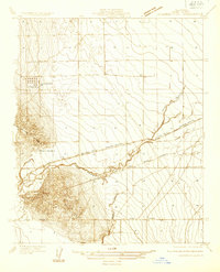
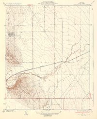
 1930 Canoas Creek1930 Print · USGSThe Fresno and Kings county line area is captured here during the 1930s oil boom. Researchers can trace early industrial landmarks like the Discovery Well near Avenal and follow the route of the Coalinga and Bakersfield Road.
 - 1933 Map of Guijarral Hills
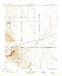
 1933 Guijarral Hills1933 Print · USGSFresno County's western oil and ranching lands are captured here in the early thirties. Local historians can trace the industrial footprint of the Oil Tank Farm and the rail-side settlement at Turk along the Southern Pacific line.
 - 1934 Map of Canoas Creek
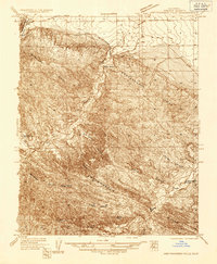
 1934 Canoas Creek1934 Print · USGSThe foothills of Fresno County appear in the early 1930s just as the oil and ranching economies were shaping the region. Researchers can trace the early street layout of Avenal and the natural paths of Canoas Creek and Zapato Creek before modern irrigation changed the land.2 unique versions available
 - 1936 Map of Kreyenhagen Hills
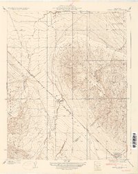
 1936 Kreyenhagen Hills1936 Print · USGSThe ranching country of southern Fresno County is documented here in the mid-1930s as the regional road network began to expand. Genealogists and historians can locate specific family landholdings like Zuburr Ranch and Hanes Ranch along the seasonal waters of Jacalitos Creek.
 - 1936 Map of Guijarral Hills, 1947 Print
 1936 Guijarral Hills1947 Print · USGSFresno County's western edge was a hub of energy and ranching in the 1930s. Researchers can trace early oil infrastructure at the Oil Tank Farm and Caliola Pumping Sta, or locate the historic Pleasant Valley Ranch near the Southern Pacific line.
 - 1937 Map of Guijarral Hills
 1937 Guijarral Hills1937 Print · USGSFresno County ranching and the early oil industry collide in this 1930s survey of the Central Valley. Trace the Southern Pacific rail line and identify family-held lands like Pleasant Valley Ranch and the industrial Oil Tank Farm.2 unique versions available
End of results
Showing maps 1-6 of 6
Top cities near Coalinga
Frequently asked questions
- What are the different types of historical maps available for Coalinga?
- What is the oldest map of Coalinga?
- Where can I purchase historical maps of Coalinga for my home or office?
- Where can I download high-res historical maps of Coalinga?
- Are there historical topographic maps available for Coalinga?
- Is there historical aerial imagery available for Coalinga?
- Where are historical maps of Coalinga sourced from?