1960s Maps of Coalinga, California
Explore 3 historic maps of Coalinga from the 1960s. These maps offer a rare glimpse into what life looked like during the 1960s — showing old roads, neighborhoods, homes, and landmarks that have changed or disappeared over time.
Whether you're researching your family's past, planning a metal detecting trip, or studying how Coalinga's landscape evolved across the 1960s, these high-resolution maps are a powerful tool for exploring the history of this region.
- Focus on a specific era: All maps on this page are from the 1960s, giving you a focused view of this time period.
- See what’s changed: Compare century-old streets, trails, and buildings to today's modern landscape using overlays and satellite layers.
- Research with precision: Use these maps for genealogy, historical research, land use analysis, or educational projects.
- View, download, or print: Maps are fully viewable online in high resolution, and can be downloaded or printed for your own records.
Start exploring Coalinga's history through authentic maps from the 1960s. This is your window into the past.
Coalinga, CA maps
(3)- 1965 Map of Santa Cruz, 1968 Print
 1965 Santa Cruz1968 Print · USGSThe Central Coast and San Joaquin Valley meet here during the mid-sixties, capturing the growth of agricultural and coastal hubs. Trace the historic Southern Pacific RR lines and locate sites like the Presidio of Monterey or Pinnacles National Monument.
 - 1969 Map of Alcalde Hills, 1973 Print
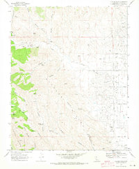 1969 Alcalde Hills1973 Print · USGSThe western edge of the Coalinga oil fields meets the rising Alcalde Hills in this late 1960s survey. Researchers can trace the industrial footprint of Oil Wells and sumps alongside natural landmarks like Sprague Cabin and Indian Springs.3 unique versions available
 - 1969 Map of Curry Mountain, 1973 Print
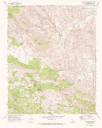 1969 Curry Mountain1973 Print · USGSThe rugged boundary between Fresno and Monterey counties comes into focus in the late 1960s, showing a land of oil exploration and high-country ranching. Researchers can trace historic routes like the Warthan Grade to find remote landmarks such as Dias Cabin, Jacalitos Ranch, and Merrill Pools.2 unique versions available
End of results
Showing maps 1-3 of 3
Top cities near Coalinga
Frequently asked questions
- What are the different types of historical maps available for Coalinga?
- What is the oldest map of Coalinga?
- Where can I purchase historical maps of Coalinga for my home or office?
- Where can I download high-res historical maps of Coalinga?
- Are there historical topographic maps available for Coalinga?
- Is there historical aerial imagery available for Coalinga?
- Where are historical maps of Coalinga sourced from?