1950s Maps of Coalinga, California
Explore 9 historic maps of Coalinga from the 1950s. These maps offer a rare glimpse into what life looked like during the 1950s — showing old roads, neighborhoods, homes, and landmarks that have changed or disappeared over time.
Whether you're researching your family's past, planning a metal detecting trip, or studying how Coalinga's landscape evolved across the 1950s, these high-resolution maps are a powerful tool for exploring the history of this region.
- Focus on a specific era: All maps on this page are from the 1950s, giving you a focused view of this time period.
- See what’s changed: Compare century-old streets, trails, and buildings to today's modern landscape using overlays and satellite layers.
- Research with precision: Use these maps for genealogy, historical research, land use analysis, or educational projects.
- View, download, or print: Maps are fully viewable online in high resolution, and can be downloaded or printed for your own records.
Start exploring Coalinga's history through authentic maps from the 1950s. This is your window into the past.
Coalinga, CA maps
(9)- 1950 Map of Canoas Creek
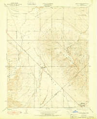 1950 Canoas Creek1950 Print · USGSMid-century oil production and the development of the Kettleman Hills dominate this landscape along the Fresno-Kings county line. Researchers can trace the early layout of Avenal and the industrial footprint of the Associated Oil Pumping Sta.
 - 1954 Map of Avenal, 1957 Print
 1954 Avenal1957 Print · USGSThe oil-rich ridges of the Kettleman Hills meet the floor of the San Joaquin Valley during a peak era of petroleum production. Researchers can trace early energy infrastructure at the Oil Refinery and Kettleman Station or locate ranch holdings like the Weeth Ranch.6 unique versions available
 - 1955 Map of Santa Cruz
 1955 Santa Cruz1955 Print · USGSCoastal Monterey Bay and the fertile Salinas Valley are captured here during the post-war expansion of the mid-fifties. Researchers can trace the era's rail-and-road network via the Southern Pacific lines and find landmarks like Fort Ord or the Lonoak School.
 - 1956 Map of Coalinga, 1957 Print
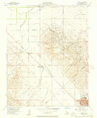
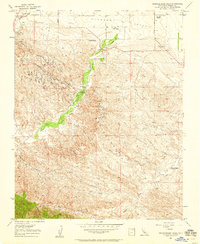
 1956 Coalinga1957 Print · USGSMid-century Coalinga thrives at the center of a massive petroleum network during the peak of its oil-producing era. Local historians can trace the foundations of the community through the Jr College, the Oil King Sch, and the Southern Pacific rail lines.7 unique versions available
 - 1956 Map of Guijarral Hills, 1957 Print
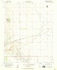 1956 Guijarral Hills1957 Print · USGSThe Central Valley oil boom was in full swing during the late fifties, transforming this landscape near Guijarral Hills. Genealogists and historians can trace industrial footprints at Turk, the Caliola Pumping Station, and the Labor Camp.3 unique versions available
 - 1956 Map of Kreyenhagen Hills, 1958 Print
 1956 Kreyenhagen Hills1958 Print · USGSThe Fresno County ranchlands and petroleum fields are captured here in the mid-1950s, showcasing the intersection of resource extraction and rural life. Researchers can trace the holdings of established family sites like Zuburi Ranch and Esrey Ranch or locate the infrastructure of the Coalinga Oil Field.3 unique versions available
 - 1956 Map of Coalinga, 1958 Print
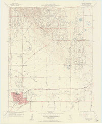
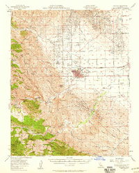 1956 Coalinga1958 Print · USGSIn the mid-1950s, the Coalinga region was a powerhouse of petroleum and ranching where industry met the Central Valley's edge. Genealogists and historians can trace family properties like Conn Ranch and Esrey Ranch alongside the vast infrastructure of the Coalinga Oil Field.2 unique versions available
 - 1957 Map of Santa Cruz
 1957 Santa Cruz1957 Print · USGSCentral California comes into sharp focus during the late fifties, from the fog-swept Monterey Bay to the sun-drenched San Joaquin Valley. Genealogists and historians can trace the mid-century footprints of Fort Ord Military Reservation, the Southern Pacific line, and the historic streets of San Juan Bautista.
 - 1958 Map of Santa Cruz
 1958 Santa Cruz1958 Print · USGSCoastal California and the central valleys are shown during the mid-fifties, capturing a landscape of massive military reserves and vital rail arteries. Genealogists and historians can trace the Southern Pacific line through Salinas or explore the early footprints of the Fort Ord Military Reservation and San Juan Bautista.2 unique versions available
End of results
Showing maps 1-9 of 9
Top cities near Coalinga
Frequently asked questions
- What are the different types of historical maps available for Coalinga?
- What is the oldest map of Coalinga?
- Where can I purchase historical maps of Coalinga for my home or office?
- Where can I download high-res historical maps of Coalinga?
- Are there historical topographic maps available for Coalinga?
- Is there historical aerial imagery available for Coalinga?
- Where are historical maps of Coalinga sourced from?