1940s Maps of Coalinga, California
Explore 4 historic maps of Coalinga from the 1940s. These maps offer a rare glimpse into what life looked like during the 1940s — showing old roads, neighborhoods, homes, and landmarks that have changed or disappeared over time.
Whether you're researching your family's past, planning a metal detecting trip, or studying how Coalinga's landscape evolved across the 1940s, these high-resolution maps are a powerful tool for exploring the history of this region.
- Focus on a specific era: All maps on this page are from the 1940s, giving you a focused view of this time period.
- See what’s changed: Compare century-old streets, trails, and buildings to today's modern landscape using overlays and satellite layers.
- Research with precision: Use these maps for genealogy, historical research, land use analysis, or educational projects.
- View, download, or print: Maps are fully viewable online in high resolution, and can be downloaded or printed for your own records.
Start exploring Coalinga's history through authentic maps from the 1940s. This is your window into the past.
Coalinga, CA maps
(4)- 1941 Map of Kreyenhagen Hills
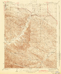 1941 Kreyenhagen Hills1941 Print · USGSWestern Fresno County ranching and transit are captured in the late 1930s, showing the intersection of valley roads and upland canyons. Genealogists and local historians can locate early family holdings like Zuburi Ranch, Kreyenhagen Ranch, and the settlement at Alcalde.2 unique versions available
 - 1942 Map of Polvadero Gap
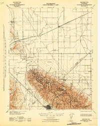 1942 Polvadero Gap1942 Print · USGSCentral California ranching and early rail corridors appear in high detail during the early war years. Genealogists and local historians can locate early family holdings like Kreyenhagen Ranch, the town of Huron, and the Southern Pacific line.2 unique versions available
 - 1944 Map of Coalinga
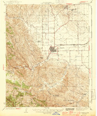 1944 Coalinga1944 Print · USGSCoalinga and its surrounding oilfields are captured here during the 1940s, showcasing the intersection of heavy industry and California ranching life. Researchers can trace the layout of the Coalinga Oil Refinery and locate legacy sites like Alcalde Ranch or the Claremont Sch.3 unique versions available
 - 1948 Map of Santa Cruz
 1948 Santa Cruz1948 Print · USGSThe Central Coast and San Joaquin Valley meet in this mid-century look at the region's agricultural and military geography. Genealogists and historians can trace the paths of El Camino Real, locate family farms near Hollister, or study the footprint of the Fort Ord Military Reservation.2 unique versions available
End of results
Showing maps 1-4 of 4
Top cities near Coalinga
Frequently asked questions
- What are the different types of historical maps available for Coalinga?
- What is the oldest map of Coalinga?
- Where can I purchase historical maps of Coalinga for my home or office?
- Where can I download high-res historical maps of Coalinga?
- Are there historical topographic maps available for Coalinga?
- Is there historical aerial imagery available for Coalinga?
- Where are historical maps of Coalinga sourced from?