1900-1909 Maps of Glenn County, California
Explore 5 historic maps of Glenn County from 1900-1909. These maps offer a rare glimpse into what life looked like during the 1900s — showing old roads, neighborhoods, homes, and landmarks that have changed or disappeared over time.
Whether you're researching your family's past, planning a metal detecting trip, or studying how Glenn County's landscape evolved across the 1900s, these high-resolution maps are a powerful tool for exploring the history of this region.
- Focus on a specific era: All maps on this page are from the 1900s, giving you a focused view of this time period.
- See what’s changed: Compare century-old streets, trails, and buildings to today's modern landscape using overlays and satellite layers.
- Research with precision: Use these maps for genealogy, historical research, land use analysis, or educational projects.
- View, download, or print: Maps are fully viewable online in high resolution, and can be downloaded or printed for your own records.
Start exploring Glenn County's history through authentic maps from the 1900s. This is your window into the past.
Glenn County, CA maps
(5)- 1904 Map of Vina
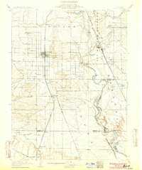 1904 Vina1904 Print · USGSThe Sacramento Valley comes alive in this early century study of the river corridor between Tehama and Butte counties. Trace the rail-and-river economy through the Winery at Vina, the Squaw Hill Ferry, and the planned Lemon Home Colony.3 unique versions available
 - 1904 Map of Walker Creek
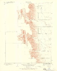
 1904 Walker Creek1904 Print · USGSGlenn County ranching country is captured during the early years of California’s state engineering efforts. Trace the natural drainage of the foothills through Walker Cr, Wilson Creek, and the headwaters of White Cabin Creek as they appeared over a century ago.
 - 1904 Map of Logan Creek, 1956 Print
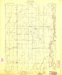
 1904 Logan Creek1956 Print · USGSGlenn and Colusa counties meet in this 1904 survey where the valley floor meets the rising foothills. Researchers can trace the original seasonal drainage paths of Logan Creek and Hunters Creek through the early land partitions of the Northern Sacramento Valley.2 unique versions available
 - 1906 Map of Maxwell
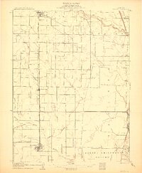
 1906 Maxwell1906 Print · USGSColusa and Glenn Counties at the dawn of the century show a landscape defined by massive land grants and new irrigation. Trace family roots and vanished river stops like Boggs Landing and Compton Landing along the Sacramento River.3 unique versions available
 - 1906 Map of Willows
 1906 Willows1906 Print · USGSThe northern Sacramento Valley is captured here at the dawn of the irrigation era, centered on the growing railroad hubs of the western plains. Researchers can trace early water infrastructure like the Central Irrigation Canal alongside vanished river landings such as Sidds Ldg and Jacinto.2 unique versions available
End of results
Showing maps 1-5 of 5
Top cities of Glenn County
Frequently asked questions
- What are the different types of historical maps available for Glenn County?
- What is the oldest map of Glenn County?
- Where can I purchase historical maps of Glenn County for my home or office?
- Where can I download high-res historical maps of Glenn County?
- Are there historical topographic maps available for Glenn County?
- Is there historical aerial imagery available for Glenn County?
- Where are historical maps of Glenn County sourced from?