1950s Maps of Glenn County, California
Explore 32 historic maps of Glenn County from the 1950s. These maps offer a rare glimpse into what life looked like during the 1950s — showing old roads, neighborhoods, homes, and landmarks that have changed or disappeared over time.
Whether you're researching your family's past, planning a metal detecting trip, or studying how Glenn County's landscape evolved across the 1950s, these high-resolution maps are a powerful tool for exploring the history of this region.
- Focus on a specific era: All maps on this page are from the 1950s, giving you a focused view of this time period.
- See what’s changed: Compare century-old streets, trails, and buildings to today's modern landscape using overlays and satellite layers.
- Research with precision: Use these maps for genealogy, historical research, land use analysis, or educational projects.
- View, download, or print: Maps are fully viewable online in high resolution, and can be downloaded or printed for your own records.
Start exploring Glenn County's history through authentic maps from the 1950s. This is your window into the past.
Glenn County, CA maps
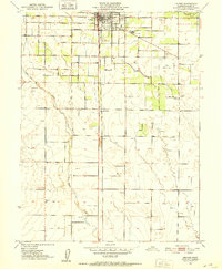
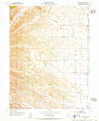
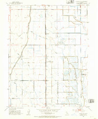
(32)- 1950 Map of Hamilton City
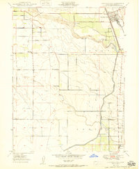 1950 Hamilton City1950 Print · USGSAgricultural Glenn County comes to life at mid-century, centered on the rail-fed hub of Hamilton City. Genealogists and historians can trace old homesteads and local institutions like Union High Sch, Ordbend, and the historic St John (Site).
 - 1950 Map of Kirkwood
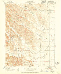
 1950 Kirkwood1950 Print · USGSThe Sacramento Valley at the mid-century shows a landscape of growing irrigation and established rail towns along the Southern Pacific line. Genealogists and local historians can trace family roots through sites like Kirkwood Cem, Lake School, and the Masonic Cem.
 - 1950 Map of Nelson
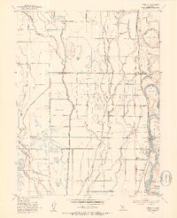
 1950 Nelson1950 Print · USGSThe northern Sacramento Valley in the mid-century shows a landscape shaped by water engineering and dual rail lines. Researchers can trace the layout of the settlement at Nelson and follow the routes of the Southern Pacific and Western Pacific railroads.
 - 1950 Map of Llano Seco
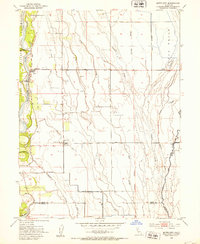
 1950 Llano Seco1950 Print · USGSThe Sacramento River bottomlands come to life in this mid-century survey of the Butte and Glenn county line. Genealogists and historians can locate old river access points like Hites Landing, trace the path of Ord Ferry Road, or study the grounds of Rancho Llano Seco.2 unique versions available
 - 1950 Map of Ord Ferry
 1950 Ord Ferry1950 Print · USGSThe Sacramento River bottomlands near the Butte and Glenn county line come into focus just after the war. Local historians can trace early valley river life through sites like Ord Ferry, the Bidwell Sch, and the historical site of Chico Landing.
 - 1950 Map of Foster Island, 1963 Print
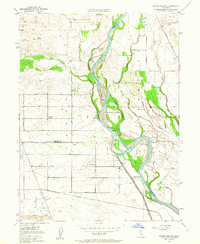 1950 Foster Island1963 Print · USGSThe Sacramento River valley at mid-century shows a landscape of river landings and evolving irrigation systems. Trace the location of former river hubs at Wilson Landing and McIntosh Ldg, or locate family landmarks like McIntosh Sch and Capay Sch.4 unique versions available
 - 1951 Map of Foster Island
 1951 Foster Island1951 Print · USGSThe Sacramento River valley in the early fifties is captured here as a landscape of river landings and organized farm blocks. Genealogists can trace family connections through named locations like Mcintosh Sch, Capay, and the historical Wilson Landing.
 - 1951 Map of Nord, 1952 Print
 1951 Nord1952 Print · USGSNorthern Butte County thrived as an orchard and rail corridor during the mid-century, before modernization shifted the rural landscape. Researchers can locate the Shasta Union Sch, trace the Southern Pacific tracks, or find family plots at the Pine Creek Cem.4 unique versions available
 - 1951 Map of Willows, 1952 Print
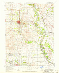
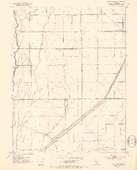
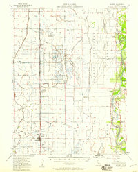
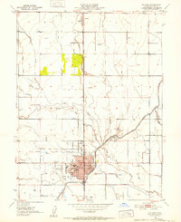 1951 Willows1952 Print · USGSThe Sacramento Valley town of Willows and the nearby settlement of Artois are shown at a peak of agricultural development in the early fifties. Researchers can trace the civic heart of the county near the Court House or follow the Southern Pacific rail line past the Willows Airport and Kanawha School.4 unique versions available
 - 1951 Map of Orland, 1952 Print
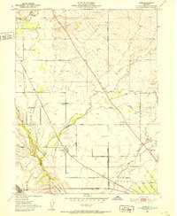
 1951 Orland1952 Print · USGSOrland and its surrounding Glenn County ranchlands are captured here in the early fifties during a period of steady agricultural development. Genealogists and local historians can locate the Price Sch, several family-named roads, and the I O O F Cemetery or Catholic Cemetery.5 unique versions available
 - 1951 Map of Glenn, 1953 Print
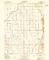 1951 Glenn1953 Print · USGSGlenn County agriculture thrived along the Sacramento River in the early fifties, supported by a vast network of irrigation canals. Genealogists and historians can trace the development of Sidds Landing, the community at Bayliss, and the rail infrastructure of the Southern Pacific.3 unique versions available
 - 1951 Map of Stonyford, 1953 Print
 1951 Stonyford1953 Print · USGSColusa and Glenn counties were still characterized by remote forest outposts and mineral springs in the early fifties. Local historians can trace family sites like Brittan Ranch or search for the Ruby King Mine and the historical Stonyford Rancheria (Site).3 unique versions available
 - 1951 Map of Corning, 1959 Print
 1951 Corning1959 Print · USGSThe Sacramento Valley in the early fifties shows a region defined by its river landings and expanding rail infrastructure. Researchers can locate family-named schools and vanished river sites such as McIntosh Landing, Kirkwood Cemetery, and Union High School.3 unique versions available
 - 1951 Map of Willows, 1959 Print
 1951 Willows1959 Print · USGSIn the early fifties, Glenn County was a thriving network of orchards and rail-side towns. Genealogists and historians can trace the foundations of Willows and Hamilton City, while locating rural landmarks like Artois Cemetery and Jacinto Grange.
 - 1952 Map of Fruto NE
 1952 Fruto NE1952 Print · USGSGlenn County ranching country is captured here in the early fifties, showing the transition from valley to foothill. Local historians can trace early water infrastructure and property sites like Michael Ranch or the Cherokee Sch (Abandoned) near Wilson Creek.3 unique versions available
 - 1952 Map of Kurand, 1953 Print
 1952 Kurand1953 Print · USGSGlenn County ranching and rail infrastructure are captured here in the early fifties during a period of transition for the Sacramento Valley. You can trace the path of the Southern Pacific Railroad Dismantled line and locate local landmarks like French Ranch and a remote cemetery.4 unique versions available
 - 1952 Map of Princeton, 1953 Print
 1952 Princeton1953 Print · USGSThe Sacramento Valley’s agricultural heartland is captured here in the early fifties, showing the intricate web of irrigation canals and river landings. Genealogists and historians can trace family locations from Minor Farm to Princeton, or locate the Codora School and the old Princeton Ferry crossing.3 unique versions available
 - 1952 Map of Butte City, 1953 Print
 1952 Butte City1953 Print · USGSGlenn County agriculture and flood control are in focus during the early fifties as the river plains transition into managed farmland. Genealogists can trace family footprints at Butte City Cemetery, Afton, and the local Union Sch.4 unique versions available
 - 1952 Map of Logandale, 1953 Print
 1952 Logandale1953 Print · USGSThe Central Valley landscape near Logandale comes into sharp focus during the early fifties as irrigation and conservation efforts transformed the terrain. Genealogists and local historians can trace family-named sites like Minor Farm or find landmarks such as Liberty School and the Peratis Duck Club.2 unique versions available
 - 1952 Map of West of Biggs, 1953 Print
 1952 West of Biggs1953 Print · USGSAgricultural development in Butte County during the post-war era is defined by its complex irrigation networks and large family holdings. Genealogists and historians can trace property boundaries and rural infrastructure through Maxwell Ranch, Schohr Ranch, and the Cherokee Canal.3 unique versions available
 - 1952 Map of Paskenta, 1953 Print
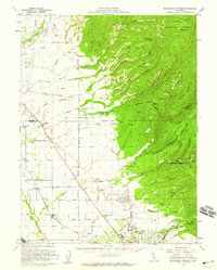
 1952 Paskenta1953 Print · USGSThe foothills of Tehama and Glenn counties come to life in this mid-century survey of the Mendocino National Forest borderlands. Genealogists and local historians can trace family holdings like the Scribner Ranch and Cushman Ranch, or find the old Lowrey Sch.3 unique versions available
 - 1952 Map of Hull Mountain, 1954 Print
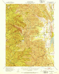
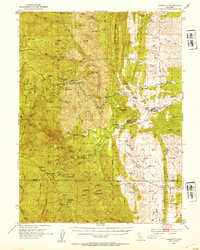
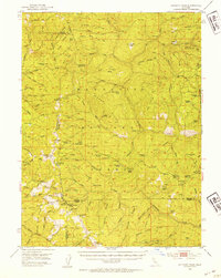
 1952 Hull Mountain1954 Print · USGSThe high ridges of Mendocino National Forest are captured here in the early 1950s, showing a landscape shaped by forest service outposts and remote mountain camps. Researchers can find old backcountry locations like Plaskett Guard Sta, Millsap Cabin, and the high meadows of Black Butte.3 unique versions available
 - 1952 Map of Anthony Peak, 1954 Print
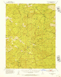
 1952 Anthony Peak1954 Print · USGSHigh mountain passes and forest service outposts define this corner of the California Coast Range during the early fifties. Local historians can locate specific mountain camps and former homesteads like Griffin Place, Howell Camp, and the Maxim Cabin (Site).4 unique versions available
 - 1952 Map of Maxwell, 1958 Print
 1952 Maxwell1958 Print · USGSThe Sacramento Valley comes alive in this mid-century survey of the Maxwell and Princeton areas, showcasing a landscape of river bends and rail sidings. Genealogists can trace family roots through several rural schools like Liberty Sch and Codora Sch, or locate the historic Cachil Dehe Rancheria.2 unique versions available
 - 1952 Map of Richardson Springs, 1959 Print
 1952 Richardson Springs1959 Print · USGSNorth of Chico in the early 1950s, the landscape shifts from the flat valley floor near Nord to the steep canyons of the Lassen National Forest. You can trace family ranching history at Stephens Ranch, locate the Old Spanish Corral, or find the secluded Richardson Springs resort area.2 unique versions available
Showing maps 1-25 of 32
Top cities of Glenn County
Frequently asked questions
- What are the different types of historical maps available for Glenn County?
- What is the oldest map of Glenn County?
- Where can I purchase historical maps of Glenn County for my home or office?
- Where can I download high-res historical maps of Glenn County?
- Are there historical topographic maps available for Glenn County?
- Is there historical aerial imagery available for Glenn County?
- Where are historical maps of Glenn County sourced from?