1980s Maps of Humboldt County, California
Explore 14 historic maps of Humboldt County from the 1980s. These maps offer a rare glimpse into what life looked like during the 1980s — showing old roads, neighborhoods, homes, and landmarks that have changed or disappeared over time.
Whether you're researching your family's past, planning a metal detecting trip, or studying how Humboldt County's landscape evolved across the 1980s, these high-resolution maps are a powerful tool for exploring the history of this region.
- Focus on a specific era: All maps on this page are from the 1980s, giving you a focused view of this time period.
- See what’s changed: Compare century-old streets, trails, and buildings to today's modern landscape using overlays and satellite layers.
- Research with precision: Use these maps for genealogy, historical research, land use analysis, or educational projects.
- View, download, or print: Maps are fully viewable online in high resolution, and can be downloaded or printed for your own records.
Start exploring Humboldt County's history through authentic maps from the 1980s. This is your window into the past.
Humboldt County, CA maps
(14)- 1982 Map of Denny
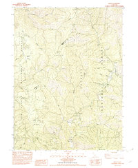 1982 Denny1982 Print · USGSTrinity County's remote mountain backcountry is captured here in the early 1980s at the intersection of two national forests. Genealogists and historians can locate mining roots at the Index Mine or trace former outposts like Elk Camp (Site) and the settlement of Hoboken.
 - 1982 Map of Orick
 1982 Orick1982 Print · USGSCoastal Humboldt County in the early eighties reveals a landscape of massive redwood preserves and protected lagoons. Genealogists and historians can trace the foundations of Orick and Trinidad alongside the Trinidad Lighthouse and Trinidad Rancheria.
 - 1982 Map of Blue Creek Mtn
 1982 Blue Creek Mtn1982 Print · USGSHumboldt and Del Norte counties meet along this remote mountain divide in the early eighties, where the Six Rivers National Forest spans deep river canyons. Genealogists and local historians can trace the paths to Bear Pen Flat, Stevens Prairie, and the heights of Blue Creek Mtn.2 unique versions available
 - 1982 Map of Panther Creek
 1982 Panther Creek1982 Print · USGSCoastal Humboldt County in the early eighties was a region of deep timber and hidden meadows bordering the federal parklands. Researchers can trace land use patterns across Redwood National Park and find remote landmarks like Barber Prairie, Shotgun Pass, and the Gaging Station on Coyote Creek.
 - 1982 Map of Hupa Mountain, 1983 Print
 1982 Hupa Mountain1983 Print · USGSHumboldt County’s steep timberlands and reservation boundaries are mapped here in the early eighties. Researchers can trace land use patterns across Hoopa Valley Indian Reservation and find local landmarks like Green Point Sch and Kings Crossing.
 - 1982 Map of Bald Hills, 1983 Print
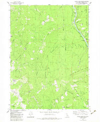
 1982 Bald Hills1983 Print · USGSHumboldt County ranching and timber lands are captured here in the early eighties. You can trace high-elevation homesteads like Lyons Ranch and Elk Camp, or locate landmarks like Schoolhouse Peak and Robbers Gulch.2 unique versions available
 - 1982 Map of Johnsons, 1983 Print
 1982 Johnsons1983 Print · USGSThe Klamath River corridor within the Hoopa Valley Indian Reservation is documented here in the early 1980s. Genealogists and local historians can trace riverfront settlements like Johnsons, Pecwan, and Cappell Flat, alongside the Jack Norton Sch.
 - 1982 Map of Hayfork, 1983 Print
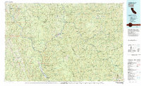
 1982 Hayfork1983 Print · USGSTrinity and Humboldt counties appear here in the early eighties as a landscape of timber and mining. Researchers can trace remote river settlements like Hyampom and Burnt Ranch or locate old operations such as the Yellowstone Mine and Index Mine.
 - 1983 Map of Hoopa
 1983 Hoopa1983 Print · USGSThe Klamath and Trinity Rivers converge in the early eighties at Weitchpec, carving through a landscape of national forests and the Hoopa Indian Reservation. Researchers can trace remote settlements like Orleans and Cecilville or locate landmarks like Tish Tang Creek and English Peak.
 - 1983 Map of Ah Pah Ridge
 1983 Ah Pah Ridge1983 Print · USGSThe Klamath River corridor near the Humboldt and Del Norte county line is shown here in the early eighties as a meeting point for national and state parks. Researchers can find family landmarks like McCovey Ranch alongside the Blue Creek Lodge (Site) and Starwein Flat.
 - 1983 Map of French Camp Ridge
 1983 French Camp Ridge1983 Print · USGSThe Klamath River and Hoopa Valley Indian Reservation lands are captured here in the early 1980s, showcasing a network of high-country prairies and remote ranches. Researchers can trace historical sites like Martins Ferry (Site), the local Cem, and the Rube Ranch.2 unique versions available
 - 1983 Map of Holter Ridge
 1983 Holter Ridge1983 Print · USGSCoastal Humboldt County in the early eighties shows a transition from ancient redwood groves to the interior tribal lands. Researchers can trace the rugged boundaries of the Hoopa Valley Indian Reservation and locate isolated clearings like Pitt Place Prairie and Hancorne Prairie.
 - 1987 Map of Eureka
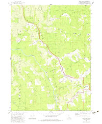
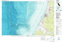 1987 Eureka1987 Print · USGSThe Humboldt County coastline in the late eighties reveals a landscape shaped by timber, transport, and the sea. Trace the Northwestern Pacific RR through Eureka or locate family roots near Ocean View Cem and Arlynda Corners.
 - 1989 Map of Cape Mendocino
 1989 Cape Mendocino1989 Print · USGSThe Humboldt coast in the late eighties reveals a landscape where massive redwoods meet the deep sea. Genealogists and historians can trace the remote outposts of Petrolia and Capetown or locate historic markers like the Punta Gorda Lighthouse.
End of results
Showing maps 1-14 of 14
Top cities of Humboldt County
- Eureka historical maps
- Arcata historical maps
- McKinleyville historical maps
- Fortuna historical maps
- Fortuna historical maps
- Rio Dell historical maps
See more
Frequently asked questions
- What are the different types of historical maps available for Humboldt County?
- What is the oldest map of Humboldt County?
- Where can I purchase historical maps of Humboldt County for my home or office?
- Where can I download high-res historical maps of Humboldt County?
- Are there historical topographic maps available for Humboldt County?
- Is there historical aerial imagery available for Humboldt County?
- Where are historical maps of Humboldt County sourced from?